- Cottonwood County, Minnesota
-
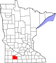
Cottonwood County, Minnesota 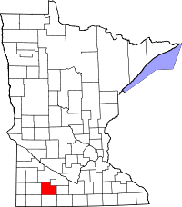
Location in the state of Minnesota
Minnesota's location in the U.S.Founded May 23, 1857[1] Named for Cottonwood River, translated from Waraju, a Dakota name of the abundant Eastern Cottonwood along its banks.[1] Seat Windom Largest city Windom Area
- Total
- Land
- Water
648.91 sq mi (1,681 km²)
639.99 sq mi (1,658 km²)
8.91 sq mi (23 km²), 1.37%Population
- (2010)
- Density
11,687
19/sq mi (7/km²)Time zone Central: UTC-6/-5 Website www.co.cottonwood.mn.us Cottonwood County is a county located in the U.S. state of Minnesota. As of 2010, the population was 11,687.[2] Its county seat is Windom[3].
Contents
History
Cottonwood County was established July, 29, 1870. It was named after the Cottonwood River which runs through the northeast corner of Germantown Township. The river received its name from the abundance of cottonwood trees on its banks.
Minnesota Governor Austin appointed three county commissioners when the county was established. They met at a private home about six miles northwest of Windom on the Des Moines River at Big Bend. During this meeting, they designated the commissioners districts and changed various county officers. In the fall of 1870, the first general election was held. The first deed on record was filed on January 10, 1870. The first land assessments were made in 1871, and in 1872, the first taxes were paid.
Windom[3] was declared the county seat in the 1872 general election and a proclamation was signed by the governor.
Presidential Election Results 2000-2008 Year Democrat Republican 2008 45.71% 2759 52.30% 3157 2004 42.80% 2726 55.85% 3557 2000 40.50% 2503 54.51% 3369 Geography
According to the 2000 census, the county has a total area of 648.91 square miles (1,680.7 km2), of which 639.99 square miles (1,657.6 km2) (or 98.63%) is land and 8.91 square miles (23.1 km2) (or 1.37%) is water.[4]
Watersheds
The northeast part of the county drains north to the Minnesota River through numerous small creeks, the Cottonwood River and Watonwan River. The southwest part of the county drains south through the Des Moines River. These two watersheds come together at the Mississippi River near Keokuk, Iowa. Most wetlands in the county have been drained for agricultural use.
Lakes
Des Moines River Watershed Minnesota River Watershed - Clear Lake: in Lakeside Township
- Clear Lake: there is another Clear Lake, mostly in Southbrook Township, but the far southern side stretches into Jackson County
- Cottonwood Lake: eastern two thirds in Lakeside Township; western third in Great Bend Township
- Harder Lake: in Dale Township
- Talcot Lake: mostly in Southbrook Township, but the far western side stretches into Murray County
- Oaks Lake: mostly in Southbrook Township, but the northern quarter is in Rose Hill Township
- Parso Lake: in Lakeside Township
- String Lakes: mostly in Great Bend Township, but the southern tip is in Jackson County
- Three Lakes: in Lakeside Township
- Warren Lake: in Great Bend Township
- Wolf Lake: in Lakeside Township
- Arnolds Lake: in Dale Township
- Augusta Lake: in Amo Township
- Bartsh Lake: in Carson Township
- Bat Lake (see Rat Lake)
- Bean Lake: in Westbrook Township
- Bingham Lake: in Lakeside Township
- Carey Lake: in Rose Hill Township
- Clear Lake: there is a third Clear Lake in Westbrook Township
- Double Lake: in Westbrook Township
- Eagle Lake: in Carson Township
- Fish Lake: northern third in Lakeside Township; southern two thirds in Jackson County
- Hurricane Lake: mostly in Highwater Township but the far western tip is in Westbrook Township and the souther third is in Storden Township
- Long Lake: in Carson Township
- Long Lake: there is another Long Lake in Rose Hill Township
- Maiden Lake: in Carson Township
- Mountain Lake: in Midway Township
- Rat Lake: in Carson Township
- Round Lake: in Westbrook Township
- Swan Lake: in Dale Township
Major highways
Adjacent counties
- Redwood County (north)
- Brown County (northeast)
- Watonwan County (east)
- Martin County (southeast)
- Jackson County (south)
- Nobles County (southwest)
- Murray County (west)
Demographics
Historical populations Census Pop. %± 1860 12 — 1870 534 4,350.0% 1880 5,533 936.1% 1890 7,412 34.0% 1900 12,069 62.8% 1910 12,651 4.8% 1920 14,570 15.2% 1930 14,782 1.5% 1940 16,143 9.2% 1950 15,763 −2.4% 1960 16,166 2.6% 1970 14,887 −7.9% 1980 14,854 −0.2% 1990 12,694 −14.5% 2000 12,167 −4.2% 2010 11,687 −3.9% U.S. Decennial Census 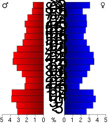 Age pyramid of county residents based on 2000 U.S. census data.
As of the census[5] of 2000, there were 12,167 people, 4,917 households, and 3,338 families residing in the county. The population density was 19 people per square mile (7/km²). There were 5,376 housing units at an average density of 8 per square mile (3/km²). The racial makeup of the county was 95.23% White, 0.34% Black or African American, 0.23% Native American, 1.63% Asian, 0.08% Pacific Islander, 1.35% from other races, and 1.14% from two or more races. 2.19% of the population were Hispanic or Latino of any race. 50.2% were of German and 18.6% Norwegian ancestry according to Census 2000.
There were 4,917 households out of which 28.60% had children under the age of 18 living with them, 58.10% were married couples living together, 6.90% had a female householder with no husband present, and 32.10% were non-families. 28.90% of all households were made up of individuals and 15.90% had someone living alone who was 65 years of age or older. The average household size was 2.39 and the average family size was 2.94.
In the county the population was spread out with 25.00% under the age of 18, 6.50% from 18 to 24, 23.20% from 25 to 44, 23.20% from 45 to 64, and 22.10% who were 65 years of age or older. The median age was 42 years. For every 100 females there were 94.50 males. For every 100 females age 18 and over, there were 91.50 males.
The median income for a household in the county was $31,943, and the median income for a family was $40,237. Males had a median income of $28,993 versus $19,934 for females. The per capita income for the county was $16,647. About 7.40% of families and 11.70% of the population were below the poverty line, including 18.40% of those under age 18 and 8.70% of those age 65 or over.
Cities and towns
Cities Townships Unincorporated † Most of Comfrey is in Brown County, but the city extends into Cottonwood County.
County parks
- Dynamite (Great Bend Township)
- Lady Bird (Southbrook Township)
- Pat's Grove (Springfield Township)[6]
- Mountain (Mountain Lake Township)
- Red Rock (Germantown Township)
- South Dutch Charlie (Westbrook Township)[7][8]
- Talcot Lake (Southbrook Township)
See also
References
- ^ a b Minnesota Place Names at Minnesota Historical Society
- ^ "2010 Census Redistricting Data (Public Law 94-171) Summary File". American FactFinder. United States Census Bureau. http://factfinder2.census.gov/faces/tableservices/jsf/pages/productview.xhtml?pid=DEC_10_PL_GCTPL2.ST05&prodType=table. Retrieved 25 April 2011.
- ^ a b "Find a County". National Association of Counties. http://www.naco.org/Counties/Pages/FindACounty.aspx. Retrieved 2011-06-07.
- ^ "Census 2000 U.S. Gazetteer Files: Counties". United States Census. http://www.census.gov/tiger/tms/gazetteer/county2k.txt. Retrieved 2011-02-13.
- ^ "American FactFinder". United States Census Bureau. http://factfinder.census.gov. Retrieved 2008-01-31.
- ^ 43°52′32″N 95°17′39″W / 43.8756°N 95.2942°W
- ^ 44°05′00″N 95°23′01″W / 44.0832°N 95.3836°W
- ^ The park is named after the county's first resident of European descent, Charles "Dutch Charlie" Zierke. "Cottonwood County Timeline". Cottonwood County Historical Society. http://www.rootsweb.ancestry.com/~mncotton/cchs.htm. Retrieved 2009-08-16.
Further reading
- Cottonwood County Minnesota Highway Map, Cottonwood County Highway Department, 2003.
- DeLorme's Minnesota Atlas and Gazetteer (ISBN 0-89933-333-8)
External links

Redwood County Brown County Murray County 
Watonwan County  Cottonwood County, Minnesota

Nobles County Jackson County Martin County Municipalities and communities of Cottonwood County, Minnesota Cities Bingham Lake | Comfrey‡ | Jeffers | Mountain Lake | Storden | Westbrook | Windom
Townships Amboy | Amo | Ann | Carson | Dale | Delton | Germantown | Great Bend | Highwater | Lakeside | Midway | Mountain Lake | Rose Hill | Selma | Southbrook | Springfield | Storden | Westbrook
Unincorporated
communityFootnotes ‡This populated place also has portions in an adjacent county or counties
Categories:- Minnesota counties
- Cottonwood County, Minnesota


Wikimedia Foundation. 2010.