- Comfrey, Minnesota
-
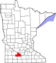
Comfrey, Minnesota — City — Location of Comfrey, Minnesota
Coordinates: 44°6′34″N 94°54′15″W / 44.10944°N 94.90417°W Country United States State Minnesota Counties Brown, Cottonwood Government – Type Mayor - Council – Mayor Gary Richter Area – Total 0.4 sq mi (1.1 km2) – Land 0.4 sq mi (1.1 km2) – Water 0.0 sq mi (0.0 km2) Elevation 1,122 ft (342 m) Population (2010)[1] – Total 382 – Density 871.9/sq mi (336.6/km2) Time zone Central (CST) (UTC-6) – Summer (DST) CDT (UTC-5) ZIP code 56019 Area code(s) 507 FIPS code 27-12772[2] GNIS feature ID 0641419[3] For the plant, see Comfrey
Comfrey is a city in Brown and Cottonwood counties in the U.S. state of Minnesota. The population was 382 at the 2010 census.[1] The majority of the people live in Brown County.
Contents
Geography
According to the United States Census Bureau, the city has a total area of 0.4 square miles (1.1 km²), all of it land.
Demographics
As of the census[2] of 2000, there were 367 people, 160 households, and 99 families residing in the city. The population density was 871.9 people per square mile (337.4/km²). There were 171 housing units at an average density of 406.2 per square mile (157.2/km²). The racial makeup of the city was 99.46% White, 0.27% Native American, and 0.27% from two or more races.
There were 160 households out of which 25.0% had children under the age of 18 living with them, 57.5% were married couples living together, 2.5% had a female householder with no husband present, and 38.1% were non-families. 34.4% of all households were made up of individuals and 25.0% had someone living alone who was 65 years of age or older. The average household size was 2.22 and the average family size was 2.74.
In the city the population was spread out with 24.3% under the age of 18, 6.8% from 18 to 24, 22.1% from 25 to 44, 18.0% from 45 to 64, and 28.9% who were 65 years of age or older. The median age was 44 years. For every 100 females there were 90.2 males. For every 100 females age 18 and over, there were 95.8 males.
The median income for a household in the city was $30,938, and the median income for a family was $40,625. Males had a median income of $32,045 versus $18,750 for females. The per capita income for the city was $14,878. About 3.8% of families and 10.8% of the population were below the poverty line, including 9.6% of those under age 18 and 4.3% of those age 65 or over.
History
On March 29, 1998, Comfrey was hit by a strong F4 tornado which damaged or destroyed most of the town.
Glen Taylor, owner of the Minnesota Timberwolves and Minnesota Lynx basketball teams and business billionaire, grew up on a farm outside Comfrey.
Politics
Comfrey is located in Minnesota's 1st congressional district, represented by Mankato educator Tim Walz, a Democrat. At the state level, Comfrey is located in Senate districts 21 and 22, represented by Republicans Gary Dahms and Doug Magnus, and in House districts 21B and 22B, represented by Republicans Paul Torkelson and Rod Hamilton.
References
- ^ a b "2010 Census Redistricting Data (Public Law 94-171) Summary File". American FactFinder. United States Census Bureau. http://factfinder2.census.gov/faces/tableservices/jsf/pages/productview.xhtml?pid=DEC_10_PL_GCTPL2.ST13&prodType=table. Retrieved 27 April 2011.
- ^ a b "American FactFinder". United States Census Bureau. http://factfinder.census.gov. Retrieved 2008-01-31.
- ^ "US Board on Geographic Names". United States Geological Survey. 2007-10-25. http://geonames.usgs.gov. Retrieved 2008-01-31.
External links
Municipalities and communities of Brown County, Minnesota Cities Cobden | Comfrey‡ | Evan | Hanska | New Ulm | Sleepy Eye | Springfield
Townships Albin | Bashaw | Burnstown | Cottonwood | Eden | Home | Lake Hanska | Leavenworth | Linden | Milford | Mulligan | North Star | Prairieville | Sigel | Stark | Stately
Unincorporated
communitiesEssig | Godahl‡ | Leavenworth | Searles
Footnotes ‡This populated place also has portions in an adjacent county or counties
Municipalities and communities of Cottonwood County, Minnesota Cities Bingham Lake | Comfrey‡ | Jeffers | Mountain Lake | Storden | Westbrook | Windom
Townships Amboy | Amo | Ann | Carson | Dale | Delton | Germantown | Great Bend | Highwater | Lakeside | Midway | Mountain Lake | Rose Hill | Selma | Southbrook | Springfield | Storden | Westbrook
Unincorporated
communityFootnotes ‡This populated place also has portions in an adjacent county or counties
Coordinates: 44°06′37″N 94°54′17″W / 44.11028°N 94.90472°W
Categories:- Cities in Minnesota
- Populated places in Brown County, Minnesota
- Populated places in Cottonwood County, Minnesota


Wikimedia Foundation. 2010.