- Cottonwood Township, Brown County, Minnesota
-
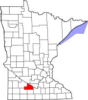
Cottonwood Township, Minnesota — Township — Location within the state of Minnesota
 Cottonwood Township, Minnesota
Coordinates: 44°15′48″N 94°25′57″W / 44.26333°N 94.4325°WCoordinates: 44°15′48″N 94°25′57″W / 44.26333°N 94.4325°W Country United States State Minnesota County Brown Area – Total 35.4 sq mi (91.7 km2) – Land 35.4 sq mi (91.6 km2) – Water 0.0 sq mi (0.1 km2) Elevation 978 ft (298 m) Population (2000) – Total 938 – Density 26.5/sq mi (10.2/km2) Time zone Central (CST) (UTC-6) – Summer (DST) CDT (UTC-5) FIPS code 27-13546[1] GNIS feature ID 0663881[2] Cottonwood Township is a township in Brown County, Minnesota, United States. The population was 938 as of the 2000 census.[3]
Contents
Geography
According to the United States Census Bureau, the township has a total area of 35.4 square miles (92 km2), of which 35.4 square miles (92 km2) is land and 0.04 square miles (0.10 km2) (0.08%) is water. The Minnesota River flows along the township's northeastern boundary; its tributaries the Cottonwood and Little Cottonwood Rivers also flow through the township.[4]
The south quarter of the city of New Ulm is within this township geographically but is a separate entity.
Unincorporated towns
(This list is based on USGS data and may include former settlements.)
Major highways
Adjacent townships
- Courtland Township, Nicollet County (northeast)
- Cambria Township, Blue Earth County (east)
- Linden Township (south)
- Lake Hanska Township (southwest)
- Sigel Township (west)
- Milford Township (northwest)
Cemeteries
The township contains these three cemeteries: Cottonwood, Saint Johns and Saint Josephs.
Demographics
As of the census[1] of 2000, there were 938 people, 340 households, and 269 families residing in the township. The population density was 26.5 people per square mile (10.2/km²). There were 346 housing units at an average density of 9.8/sq mi (3.8/km²). The racial makeup of the township was 99.04% White, 0.85% Asian, and 0.11% from two or more races. Hispanic or Latino of any race were 0.53% of the population.
There were 340 households out of which 37.1% had children under the age of 18 living with them, 69.4% were married couples living together, 7.6% had a female householder with no husband present, and 20.6% were non-families. 17.9% of all households were made up of individuals and 6.2% had someone living alone who was 65 years of age or older. The average household size was 2.76 and the average family size was 3.13.
In the township the population was spread out with 27.9% under the age of 18, 7.8% from 18 to 24, 27.9% from 25 to 44, 24.9% from 45 to 64, and 11.4% who were 65 years of age or older. The median age was 38 years. For every 100 females there were 108.0 males. For every 100 females age 18 and over, there were 109.3 males.
The median income for a household in the township was $48,750, and the median income for a family was $60,000. Males had a median income of $31,726 versus $24,667 for females. The per capita income for the township was $21,299. About 4.2% of families and 6.9% of the population were below the poverty line, including 9.7% of those under age 18 and 5.2% of those age 65 or over.
References
- United States National Atlas
- United States Census Bureau 2007 TIGER/Line Shapefiles
- United States Board on Geographic Names (GNIS)
- ^ a b "American FactFinder". United States Census Bureau. http://factfinder.census.gov. Retrieved 2008-01-31.
- ^ "US Board on Geographic Names". United States Geological Survey. 2007-10-25. http://geonames.usgs.gov. Retrieved 2008-01-31.
- ^ United States Census Bureau American FactFinder - Cottonwood Township total population
- ^ Minnesota Atlas & Gazetteer. Yarmouth, Me.: DeLorme. 1994. pp. 31. ISBN 0-89933-222-6.
Municipalities and communities of Brown County, Minnesota Cities Cobden | Comfrey‡ | Evan | Hanska | New Ulm | Sleepy Eye | Springfield
Townships Albin | Bashaw | Burnstown | Cottonwood | Eden | Home | Lake Hanska | Leavenworth | Linden | Milford | Mulligan | North Star | Prairieville | Sigel | Stark | Stately
Unincorporated
communitiesEssig | Godahl‡ | Leavenworth | Searles
Footnotes ‡This populated place also has portions in an adjacent county or counties
Categories:- Townships in Brown County, Minnesota


Wikimedia Foundation. 2010.