- Little Cottonwood River
Geobox River
name = Little Cottonwood River
native_name =
other_name =
other_name1 =
image_size = 290
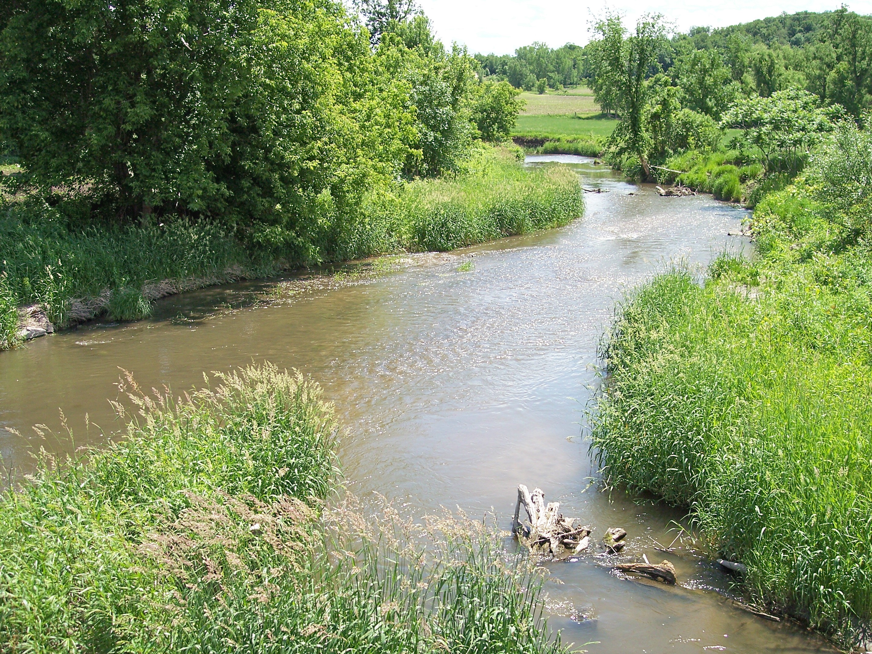
image_caption = The Little Cottonwood River near its mouth in Cambria Township in 2007
country = United States
state = Minnesota
region =
region1 =
district =
district1 =
city =
city1 =
length_imperial = 82.9
length_note = [cite web |url= http://mrbdc.mnsu.edu/major/midminn/desc28.html |title= Middle Minnesota River Major Watershed. |pages= [http://mrbdc.mnsu.edu/major/midminn/descstream28.html Streams within the Middle Minnesota River Major Watershed] |publisher= Minnesota River Basin Data Center.Minnesota State University, Mankato |date= 2000-06-06 |accessdate= 2007-06-03]
watershed_imperial = 230
watershed_note = cite web |url= http://www.pca.state.mn.us/water/basins/mnriver/watersheds.html |title= Watersheds of the Minnesota River Basin. |pages= [http://www.pca.state.mn.us/water/basins/mnriver/watershed-middlemn.pdf Minnesota River Basin: Middle and Lower Minnesota River Watersheds] |publisher= Minnesota Pollution Control Agency |date= 2005-12-01 |accessdate= 2007-06-03]
discharge_location = Cambria Township
discharge_imperial = 72.5
discharge_max_imperial = 3520
discharge_min_imperial = 0.1
discharge_note = cite web |url=http://pubs.usgs.gov/wdr/2005/wdr-mn-05-1/ |pages = [http://pubs.usgs.gov/wdr/2005/wdr-mn-05-1/05317200.2005.sw.pdf Little Cottonwood River near Courtland, MN] |title=Water Resources Data in Minnesota, Water Year 2005 Annual Report. |first= G. B. |last=Mitton |coauthors=K. G. Guttormson, G. W. Stratton, E. S. Wakeman |publisher=United States Geological Survey |accessdate=2007-06-03]
discharge1_location =
discharge1_imperial =
source_name =
source_location = Amboy Township
source_district = Cottonwood County
source_region =
source_lat_d = 44
source_lat_m = 02
source_lat_s = 28
source_lat_NS = N
source_long_d = 95
source_long_m = 11
source_long_s = 35
source_long_EW = W
source_coordinates_note = cite web |url=Gnis3|646788 |title=Geographic Names Information System entry for Little Cottonwood River (Feature ID #646788) |author=Geographic Names Information System |authorlink=Geographic Names Information System|accessdate=2007-06-03]
source_elevation_imperial = 1467
source_elevation_note =Google Earth elevation forGNIS coordinates. Retrieved on2007-06-03 .]
source_length_imperial =
mouth_name = Minnesota River
mouth_location = Cambria Township
mouth_district = Blue Earth County
mouth_region =
mouth_lat_d = 44
mouth_lat_m = 15
mouth_lat_s = 05
mouth_lat_NS = N
mouth_long_d = 94
mouth_long_m = 19
mouth_long_s = 47
mouth_long_EW = W
mouth_coordinates_note =
mouth_elevation_imperial = 787
mouth_elevation_note =
tributary_left =
tributary_left1 =
tributary_right =
tributary_right1 =
free_name =
free_value =
map_size =
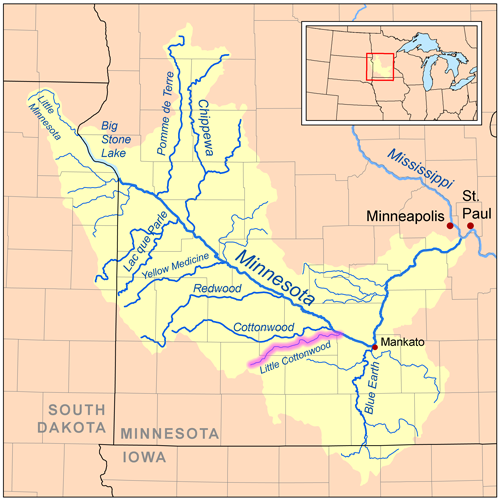
map_caption =The Little Cottonwood River is a
tributary of theMinnesota River , 83 miles (133 km) long, in southwesternMinnesota in theUnited States . Via the Minnesota River, it is part of the watershed of theMississippi River , draining an area of 230 square miles (596 km²) in an agricultural region.The Little Cottonwood River rises south of Jeffers in Amboy Township in Cottonwood County, beginning as a drainage ditch constructed in 1997. In its upper course the stream flows swiftly in a northeastward course and passes rock outcrops, including the
Jeffers Petroglyphs . It flows generally east-northeastwardly through Brown County into northwestern Blue Earth County, where it joins the Minnesota River in Cambria Township, approximately seven miles (11 km) southeast of New Ulm. For much of its lower course, it roughly parallels the Cottonwood River to the north at a distance of three to ten miles (5-15 km). The stream's watershed is narrow, with no major tributaries. Land within the watershed consists primarily oftill plain s; as of|1990|lc=on, 90% of the land was cultivated for agriculture.cite web |url= http://mrbdc.mnsu.edu/ |title= Minnesota River Basin Data Center. |pages= [http://mrbdc.mnsu.edu/major/midminn/subshed/lcotwd/index.html Little Cottonwood River Virtual Tour] |publisher= Minnesota River Basin Data Center.Minnesota State University, Mankato |date= 2000-06-06 |accessdate= 2007-06-03] [cite book| title= Minnesota Atlas & Gazetteer |year=1994 |publisher=DeLorme |location=Yarmouth, Me. |isbn= 0-89933-222-6 |pages= pp. 21, 30-31]Common fish in the river include black and
yellow bullhead ,rock bass ,golden redhorse , and various species of darters and shiners.Flow rate
At the
United States Geological Survey 'sstream gauge in Cambria Township, 0.7 miles (1.1 km) upstream from the river's mouth, the annual mean flow of the river between 1974 and 2005 was 72.5cubic feet per second (2 m³/s). The highest recorded flow during the period was 3,520 ft³/s (100 m³/s) onJune 20 ,1993 . The lowest recorded flow was less than 0.1 ft³/s (0 m³/s) onSeptember 17 ,1977 .ee also
*
List of rivers in Minnesota References
Wikimedia Foundation. 2010.