- 1998 Comfrey
-
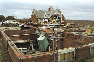
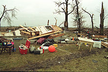
1998 Comfrey – St. Peter tornado outbreak A house blown off its foundation near Hanska, Minnesota Date of tornado outbreak: March 29, 1998 Duration1: 4 hours Maximum rated tornado2: F4 tornado Tornadoes caused: 16 Damages: $235 million (1998 USD)
$310 million (2008 USD)Fatalities: 2 Areas affected: southern Minnesota, Wisconsin 1Time from first tornado to last tornado
2Most severe tornado damage; see Fujita ScaleThe 1998 Comfrey – St. Peter tornado outbreak was an unseasonably-strong tornado outbreak which affected the Upper Midwest region of the United States on March 29, 1998. A strong area of low pressure combined with a warm front and favorable upper-level dynamics to produce 16 tornadoes across the region—14 in Minnesota and two in Wisconsin. Thirteen of the tornadoes in Minnesota were spawned by a single supercell thunderstorm. This supercell remained intact for approximately 150 miles (240 km) as it moved across the southern part of the state during the late-afternoon hours.
Over $235 million in damage (1998 USD) was recorded from the tornadoes, two people were killed, and 21 others were injured. Most of the damage was caused by three tornadoes—one rated F4 on the Fujita scale that hit the town of Comfrey, Minnesota, an F3 that hit St. Peter, Minnesota, and an F2 that hit Le Center, Minnesota. Gustavus Adolphus College in St. Peter was especially hard-hit, with several buildings damaged or destroyed, 2,000 trees lost, and nearly 80% of the windows on the campus shattered. In Comfrey, 75% of the structures in the town were damaged or destroyed, including the local K–12 school. Seven counties in southern Minnesota were later declared federal disaster areas.
The outbreak broke many early-season tornado records for the state of Minnesota. The 14 total tornadoes in the state were the most to ever touch down on a single day in March. The F4 tornado was the strongest ever recorded in the state in March, and its 67-mile (108 km) path the longest tornado path ever recorded in Minnesota. In December 1998, the United States Department of Commerce awarded a bronze medal to the Twin Cities office of the National Weather Service (NWS) for providing excellent service to the public during the outbreak event.
Contents
Meteorological synopsis
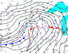
The driving force behind this tornado outbreak was a strong surface-based low-pressure area stationed over the western high plains. On the morning of March 29, the low was centered over eastern Wyoming, with a warm front stretching eastward across Nebraska and Iowa.[1] An upper-level trough of low pressure was centered over the southwestern United States, which caused an upper-level jet stream with winds of 100 knots (120 mph; 190 km/h) to push towards Minnesota from the southwest. A low-level jet from the south with winds of 50 knots (60 mph; 90 km/h) transported a plume of warm, humid air into the region, helping to push temperatures above 70 °F (23 °C) and dew points into the middle 60s °F (around 20 °C).[1] Winds on the surface were from the southeast, which created low-level wind shear; enhancing the potential for tornadoes.[2]
By early afternoon, the low-pressure area had moved east into Nebraska, while the warm front had moved northward into southern Minnesota.[1] The atmosphere to the south of the warm front was strongly capped, meaning that the best chance of thunderstorm development was in areas along and slightly north of the front.[3] By the time the thunderstorms started developing, CAPE values were 2000 J/kg, indicating moderate atmospheric instability.[4] Also present were low-level and deep-layer wind shear values of 44 knots (51 mph; 81 km/h) and 87 knots (100 mph; 161 km/h), respectively. All of these factors combined to create very favorable conditions for the development of severe thunderstorms and tornadoes.[1]
Forecasts
Weather forecasters first began to notice the severity of the impending weather situation after the 6:00 pm CST (0000 UTC) computer model runs on the night of Friday, March 27.[3] On Saturday, March 28 at 11:30 am the Storm Prediction Center issued a Day 2 moderate risk of severe weather for southeast Minnesota, northeast Iowa, northwest Illinois and much of Wisconsin.[5] Later model runs on March 28 only increased forecasters' confidence that a major severe-weather event would occur the following day.[3]
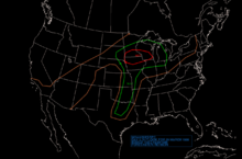
In the early-morning hours of Sunday March 29, forecasters at the Twin Cities NWS noticed that due to the model's prediction of strong wind shear and instability, the tornado risk was quite high for their region. Area forecast discussions during this period mentioned the possibility of F3-strength tornadoes later in the day.[3] Also on the morning of March 29, the Storm Prediction Center issued a Day 1 moderate risk of severe weather. This moderate risk area was more narrow than the previous day's outlook, encompassing only southwest Wisconsin, northern Iowa and the southern third of Minnesota.[1]
As the day moved on, the Twin Cities, Sioux Falls and La Crosse NWS forecast offices all saw the potential for "strong to violent" tornadoes, and used such verbiage in their forecasts.[1] The Twin Cities NWS noted in their 12:26 pm forecast discussion that "thunderstorms located south of a Redwood Falls to Minneapolis to Rice Lake line could be particularly strong with the potential of tornadic thunderstorms".[3] Just before 12:00 pm, the Storm Prediction Center issued a mesoscale discussion stating that "[g]iven strength of vertical shear profiles, CAPE on the order of 2000 J/kg will support increasing potential for tornadic supercells during the afternoon hours, especially along an axis roughly from Yankton through Sioux Falls into Redwood Falls and Minneapolis/Rochester areas. We will continue to monitor. Present indications are WW (Weather Watch) will be necessary within the next 2 to 3 hours."[3] At 1:35 pm the Storm Prediction Center issued tornado watch #132 with a particularly dangerous situation designation. The watch area encompassed most of southern Minnesota and northern Iowa, along with small parts of northeast Nebraska, southeast South Dakota, southwest Wisconsin, and was made in effect from 2:00 pm to 8:00 pm.[5]
Outbreak description
 Radar image of the supercell thunderstorm as it produced an F4 tornado in Brown County, Minnesota
The thunderstorms that would eventually spawn the tornadoes began forming in southeastern South Dakota around 2:00 pm. The first severe weather report of the outbreak was of 3⁄4 inches (19 mm) diameter hail 2 miles (3 km) south of Brandon, South Dakota.[6] Shortly thereafter the thunderstorms moved east across the border into Minnesota. After several more reports of severe hail with the growing thunderstorms,[7][8] the first tornado of the day—rated F2 on the Fujita scale—touched down at 3:23 pm 2 miles (3 km) north of Lismore.[9] It was on the ground for less than 1 mile (2 km) and caused minor damage. Five more tornadoes (all rated F2 or lower) briefly touched down during the next hour in the same general area; none of which inflicted major damage. All of these tornadoes were spawned by the same supercell thunderstorm. During the remainder of the afternoon hours, this supercell would proceed to track east-northeast across southern Minnesota for 150 miles (240 km), tracking slightly north of the warm front.[10]
Comfrey
At 3:50 pm a tornado touched down 7 miles (11 km) east of Avoca, Minnesota in eastern Murray County.[11] As the tornado moved through Cottonwood County, it grew to a width of 900 yards (823 m) and obtained F3 strength.[12] It destroyed numerous farms, farm equipment, trees, power lines and poles, vehicles, and other structures in its path. Twenty people outside a church near Jeffers were able to get inside the church just before the tornado hit, and as a result nobody suffered serious injuries.[10][13]
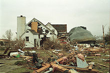
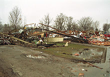
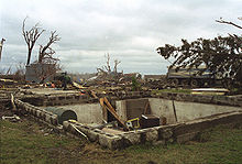
At approximately 4:30 pm the twister, which witnesses described as a "mass of blowing dust" or "rolling fog bank"[10] entered Comfrey, a town of 550 people located in both Cottonwood and Brown Counties. Comfrey's fire chief saw the tornado while storm spotting and ordered the town's sirens activated.[14] The tornado moved through the center of Comfrey one minute after the sirens went off, and destroyed a grain elevator, the town hall, three of the town's four churches, the grocery store, and most of the main street businesses downtown.[15][16] The town's firehouse collapsed, and the school was heavily damaged. Of the 200 houses in the town, all but 15 suffered damage. Fifty of those homes were destroyed and as a result 100 people were left homeless.[15][16] Approximately 75% of the buildings in Comfrey were damaged or destroyed.[15][17]
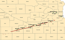
As the tornado continued to move through Brown County it achieved F4 strength and grew to 1.25 miles (2 km) wide.[15] Approximately 15% of the 1000 farms in Brown County sustained damage from the tornado,[18] and 500 dairy cattle were lost.[15] The tornado went on to cause additional damage in Blue Earth and Watonwan Counties. After traveling across six counties for 1 hour and 25 minutes and causing $75 million in damage,[12][15] the twister lifted back into the clouds at 5:15 pm 4 miles (6 km) southeast of Courtland.[13][19] In addition, 19 people were injured by this tornado.
St. Peter
At 5:18 pm, the same supercell produced another large tornado 2 miles (3 km) to the east of Nicollet. As the tornado moved to the east, a six year-old boy was killed when the vehicle his family was riding in was overtaken by the tornado.[10] At 5:30 pm the F3 tornado hit St. Peter, a town of about 10,000 people located in eastern Nicollet County, and inflicted severe damage on much of the town.[20] Gustavus Adolphus College, which sits on top of a hill on the west side of St. Peter, sustained heavy damage after taking a direct hit from the twister. Eighty percent of the windows on the campus were shattered, and most of the major buildings on campus sustained damaged.[21] The chapel spire—a campus landmark—was snapped in half. The admissions office was destroyed, as was Johnson Hall, a small dormitory.[22] The Lund Center for Physical Education and Health lost part of its roof, as did the tennis center. The football press box was blown from the top of the stadium bleachers, and the baseball dugouts were damaged.[23] The tornado also uprooted more than 1000 trees, almost completely denuding the campus.[17] Gustavus was on spring break at the time the tornado hit, so the campus was virtually vacant of students and there were no serious injuries or fatalities reported.[22]
As the tornado continued through St. Peter it caused more damage and destruction. St. Peter's Catholic Church and St. Peter Evangelical Lutheran Church were destroyed, as was the Arts and Heritage Center.[24] The hospital was severely damaged and the library was hit, resulting in a loss of 25% of its books.[25] Officials estimated 500 homes in St. Peter were destroyed, 1700 more were damaged and over 17,000 trees were lost.[21][26] Many of the homes and trees that were destroyed in St. Peter were more than a century old. Debris from St. Peter that was sucked into the tornado fell back down to earth as far as Rice Lake, Wisconsin, over 130 miles (209 km) away.[10] In addition to the damage in St. Peter, the tornado also damaged or destroyed 60 homes and caused $6.5 million in damage in rural areas.[25] All together this tornado was on the ground for 18 miles (29 km) and inflicted $120 million in damage.[25]
Le Center
Shortly after the St. Peter tornado dissipated, a new tornado formed at 5:48 pm 2 miles (3 km) north of Cleveland, Minnesota.[27] The half-mile (.8 km) wide tornado damaged several farms before hitting Le Center at F2 strength. The tornado damaged many businesses on the southern side of town and caused heavy damage at the Le Sueur County fairgrounds.[27] The Sunny Terrace mobile home park in Le Center took a direct hit from the tornado. Fifteen mobile homes were destroyed and another 26 were heavily damaged.[27] The manager of the mobile home park was able to alert residents to the oncoming tornado, allowing most of them to take cover in a storm shelter before the storm hit.[20] There were no fatalities from this tornado, and two people sustained injures. After traveling for 17 miles (27 km) and causing $20 million in damage, the tornado lifted from the ground 1 mile (2 km) west of the town of Montgomery.[27]
Other tornadoes
Over the next hour the supercell continued to track across southern Minnesota, dropping four more tornadoes in Rice and Dakota Counties.[13] One of these tornadoes hit the town of Lonsdale at F2 strength, damaging four homes and six business in the town, and then 20 farms to the east of town. This tornado had a path of 5 miles (8 km) and caused $20 million in damage.[28] The last of the 13 tornadoes spawned by this supercell was a brief F0 that touched down 5 miles (8 km) southwest of Hastings,[29] and the supercell dissipated a few minutes later as it moved into Wisconsin.[10]
Four additional tornadoes touched down this day. A tornado that was associated with the main supercell touched down briefly near Fulda, Minnesota at 3:55 pm, while the Comfrey tornado was also on the ground. It was rated as an F1 and caused minor damage. Three other tornadoes that were all unrelated to the main supercell were confirmed as well; one in southeast Minnesota near Wabasha and two in Wisconsin. All three were rated F0 on the Fujita Scale and produced only minor damage.[30][31][32]
Confirmed tornadoes
Confirmed
TotalConfirmed
F0Confirmed
F1Confirmed
F2Confirmed
F3Confirmed
F4Confirmed
F516 6 3 5 1 1 0 List of confirmed tornadoes – Sunday, March 29, 1998 F# Location County Time (UTC) Path length Damage Minnesota F2 N of Lismore Nobles 2123 0 mi $400 thousand in damage to farm buildings and equipment.[9] F0 E/ESE of Leota Nobles 2125 pm 0 mi $10 thousand in damage to a few buildings.[33] F0 N of Wilmont Nobles 2128 pm 0 mi $50 thousand in damage to a few buildings.[34] F2 NW of St. Kilian Nobles 2135 pm 0 mi $200 thousand in damage to buildings and a tractor trailer.[35] F1 NE of St. Kilian Nobles 2145 pm 0 mi $100 thousand in damage to farm buildings.[36] F4 Comfrey area Murray, Cottonwood, Brown, Watonwan, Blue Earth, Nicollet 2150 pm 67 mi (108 km) 1 death, 19 injuries. Substantial damage to the town of Comfrey and many farms across six Minnesota counties. $75 million in damage.[11][12][15][19][37][38] F1 SW of Fulda Murray 2155 pm 0 mi $50 thousand in damage to farm buildings.[39] F0 W of Wabasha Wabasha 2307 pm 2 mi (3 km) None reported.[30] F3 St. Peter area Nicollet, Le Sueur 2318 pm 18 mi (29 km) 1 death. $120 million in damage to the town of St. Peter, Gustavus Adolphus College heavily damaged.[25][40] F2 Le Center area Le Sueur 2348 pm 17 mi (27 km) 2 injuries. Southern portion of Le Center sustains $20 million in damage.[27] F1 SW of Lonsdale Rice 0009 pm 0 mi None reported.[41] F2 Lonsdale Rice 0016 pm 5 mi (8 km) Homes, farms and businesses destroyed, $20 million in damage.[28] F2 WNW of Castle Rock Dakota 0025 pm 3 mi (5 km) None reported.[42] F0 SW of Hastings Dakota 0043 pm 1 mi (1.6 km) None reported.[29] Wisconsin F0 S of Maxville Buffalo 2315 pm 1 mi (1.6 km) None reported.[31] F0 NW of Tomahawk Lincoln 0128 pm 1 mi (1.6 km) $15 thousand in damage to sheds and garages.[32] Source: National Climatic Data Center[43] Aftermath
On April 1, 1998, seven counties in Minnesota were declared federal disaster areas: Brown, Le Sueur, Nicollet, Rice, Cottonwood, Blue Earth and Nobles.[44] The money allotted from the federal government allowed the affected towns to clean up the damage and begin the rebuilding process. In addition to the federal dollars, the state of Minnesota contributed $27.6 million to the cleanup and rebuilding effort,[45] with $1.35 million designated specifically for the preservation of the historical buildings in St. Peter.[46][47] Most of St. Peter's buildings that were on the National Historic Register were damaged, but only one—a French Second Empire school building built in 1871 (St. Peter Central School)—had to be demolished.[48] Three years after the tornado, the City of St. Peter reported that its population had grown by 2%; an unusual feat for a town that had so recently endured a natural disaster.[49]
Damage to the Gustavus campus was estimated at nearly $60 million.[21] Despite 33 of the 78 of the classrooms not being ready for use, the college re-opened three weeks after the tornado.[50] Following the storm, a major concern for the college was that the student base would be eroded. To prevent that from happening, every returning and graduating student was given a $3,000 check by the college. In addition, the school sent out letters and made phone calls to all 2,000 applicants within 10 days of the disaster. The 735 new students who reported to Gustavus the following fall comprised the largest incoming class in the school's history.[22] After a summer of repairs, the symbolic end to the rebuilding process on campus occurred on October 22, 1998 when a new 175-foot (53 m) spire was placed atop the chapel.[51]
Following the tornado in Comfrey, residents were forced to temporarily evacuate the town due to several gas leaks,[20] and the Minnesota National Guard was called in to help secure the area. Because the town's K–12 school was destroyed, students resumed classes two weeks later 20 miles (32 km) to the north in Sanborn. Since many Comfrey residents were displaced to nearby towns, school buses from Comfrey drove to each town to provide children transportation to the school in Sanborn.[52] To help stock their classrooms, the school used equipment and supplies that had been salvaged from the damage as well as items that had been donated.
Immediately following the tornado in Comfrey there was uncertainty about the town's long-term survival.[53] Then in the week following the tornado the town decided to rebuild the school, and as a result most of Comfrey's businesses decided to follow suit.[54] Ground was broken on the new school early the next year, and it opened to students on October 4, 1999.[55] The population of Comfrey is down to 367 from the 425 it was when the tornado hit.[26]
Official U.S. government totals gathered in the months following the disaster state that the tornadoes caused $235 million in damage,[56] however later estimates put the total much higher, including over $300 million in St. Peter alone.[26] Additionally, over $800,000 in hail and downburst damage was reported over South Dakota, Minnesota and Wisconsin.[43]
For the 13 tornadoes that touched down from the parent supercell in southern Minnesota, the Twin Cities and Sioux Falls NWS offices issued tornado warnings an average of 15 minutes before the warned areas were hit.[5] Because of above-average lead time for the warnings, and for excellence in forecasting the entire event, a bronze medal was issued to the Twin Cities NWS office the following December by the United States Department of Commerce.[5][57]
Historical perspective
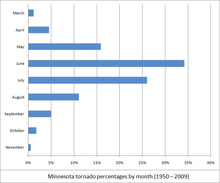
Tornadoes during the month of March are an unusual occurrence in Minnesota when compared to the rest of the spring and summer months.[58] Before this event there had been only six tornadoes ever recorded in the state during March, and since this event there has been only one.[59] This outbreak also marks the first time in Minnesota history that two tornadoes were recorded on the same day in March,[60] as well as the first time since 1921 that there have been multiple tornado fatalities on the same March day.[61] Despite the historical significance of the outbreak, this was not the earliest calendar-year tornado to touch down in Minnesota; that record is held by a tornado that touched down near Truman on March 18, 1968.[62]
With a path of 67 miles (108 km), the Comfrey tornado had the fifth-longest track of any tornado on record in Minnesota.[60] It is however the longest continuous-track tornado in Minnesota history, meaning that it was the longest to have been observed to always be in contact with the ground.[60] The damage from the F4 tornado that struck Comfrey is the strongest ever measured in Minnesota during the month of March. The previous strongest-measured were two F3's, occurring on March 27, 1905 and March 26, 1921.[60]
See also
- Climate of Minnesota
- List of Minnesota weather records
- List of North American tornadoes and tornado outbreaks
References
- ^ a b c d e f "What Weather Conditions Made This Happen?". The Southern Minnesota Tornadoes of March 29, 1998. National Weather Service (NWS) – Twin Cities. March 6, 2008. http://www.crh.noaa.gov/mpx/?n=1998mar29wxpattern. Retrieved 2008-03-13.
- ^ Wood, Amanda (2006) (PDF). Mesoscale Supercell Dynamics of the Comfrey/St. Peter Tornado Outbreak March 29, 1998. University of Wisconsin. http://www.aos.wisc.edu/uwaosjournal/Volume1/AOS453/FCS_Wood.pdf. Retrieved 2008-06-14.
- ^ a b c d e f "The National Weather Service Perspective". The Southern Minnesota Tornadoes of March 29, 1998. NWS – Twin Cities. April 20, 2008. http://www.crh.noaa.gov/mpx/?n=1998mar29nwsstories. Retrieved 2008-05-08.
- ^ "CAPE for Instability Descriptors". Storm Prediction Center. http://www.spc.noaa.gov/misc/tables/capetext.htm. Retrieved 2008-08-04.
- ^ a b c d "What National Weather Service Forecasts and Warnings Were Issued?". The Southern Minnesota Tornadoes of March 29, 1998. NWS – Twin Cities. March 6, 2008. http://www.crh.noaa.gov/mpx/?n=1998mar29forecasts. Retrieved 2008-05-08.
- ^ "Event Record Details – Brandon hail". National Climatic Data Center (NCDC). March 29, 1998. http://www4.ncdc.noaa.gov/cgi-win/wwcgi.dll?wwevent~ShowEvent~339866. Retrieved 2008-03-10.
- ^ "Event Record Details – Hardwick hail". NCDC. March 29, 1998. http://www4.ncdc.noaa.gov/cgi-win/wwcgi.dll?wwevent~ShowEvent~325571. Retrieved 2008-03-29.
- ^ "Event Record Details – Edgerton hail". NCDC. March 29, 1998. http://www4.ncdc.noaa.gov/cgi-win/wwcgi.dll?wwevent~ShowEvent~325573. Retrieved 2008-03-29.
- ^ a b "Event Record Details – Lismore tornado". NCDC. March 29, 1998. http://www4.ncdc.noaa.gov/cgi-win/wwcgi.dll?wwevent~ShowEvent~325578. Retrieved 2008-07-29.
- ^ a b c d e f "Five Year Anniversary of the Comfrey/ St. Peter Tornado Outbreak". NWS – Twin Cities. March 26, 2003. http://climate.umn.edu/doc/journal/comfrey_tornado_five_year.htm. Retrieved 2006-12-22.
- ^ a b "Event Record Details – Avaca tornado". NCDC. March 29, 1998. http://www4.ncdc.noaa.gov/cgi-win/wwcgi.dll?wwevent~ShowEvent~325591. Retrieved 2008-05-15.
- ^ a b c "Event Record Details – Westbrook tornado". NCDC. March 29, 1998. http://www4.ncdc.noaa.gov/cgi-win/wwcgi.dll?wwevent~ShowEvent~325593. Retrieved 2008-05-15.
- ^ a b c "What Happened?". The Southern Minnesota Tornadoes of March 29, 1998. NWS – Twin Cities. March 6, 2008. http://www.crh.noaa.gov/mpx/?n=1998mar29intro. Retrieved 2008-03-13.
- ^ Steil, Mark (March 30, 1998). "Living Through the Tornado in Comfrey". Minnesota Public Radio. http://news.minnesota.publicradio.org/features/199803/30_steilm_comfrey-m/. Retrieved 2008-07-20.
- ^ a b c d e f g "Event Record Details – Comfrey tornado". NCDC. March 29, 1998. http://www4.ncdc.noaa.gov/cgi-win/wwcgi.dll?wwevent~ShowEvent~325608. Retrieved 2008-05-15.
- ^ a b Meryhew, Richard (April 13, 1998). "Starting over; People in Comfrey are coming together to overcome a storm's devastating blow with rebuilding plans to resurrect their lives and a place that's more than home.". Star Tribune (Avista Capital Partners).
- ^ a b Seeley, Mark (2006). Minnesota Weather Almanac. Minnesota Historical Society press. pp. 196–197. ISBN 0873515544.
- ^ Steil, Mark (March 29, 1999). "Tornado Anniversary". Minnesota Public Radio. http://news.minnesota.publicradio.org/features/199903/29_steilm_tornado-m/. Retrieved 2008-07-25.
- ^ a b "Event Record Details – Courtland tornado". NCDC. March 29, 1998. http://www4.ncdc.noaa.gov/cgi-win/wwcgi.dll?wwevent~ShowEvent~325615. Retrieved 2008-05-15.
- ^ a b c Associated Press (March 14, 2000). "Twisters kill two in southern Minnesota". USA Today (Gannett Company). http://www.usatoday.com/weather/tornado/wtor329.htm. Retrieved 2008-05-15.
- ^ a b c Thomas, Matt (February 29, 2008). "Gustavus to Commemorate Tenth Anniversary of 1998 Tornado". Gustavus Media Relations. http://gustavus.edu/news/3755. Retrieved 2008-05-15.
- ^ a b c Garrison, Luke (March 14, 2008). "Detestation and Renewal". The Gustavian Weekly. http://weekly.blog.gustavus.edu/2008/03/14/devastation-and-renewal/. Retrieved 2008-05-15.
- ^ Meryhew, Rochard; Anthony Longtree (March 31, 1998). "Gustavus Adolphus College loses a landmark; Storm's toppling of steeple strips campus of its `heart and soul'". Star Tribune (Avista Capital Partners).
- ^ Meryhew, Richard; Robert Franklin (September 29, 1998). "Six Months After; Tornado-torn towns still trying to pick up the pieces". Star Tribune (Avista Capital Partners).
- ^ a b c d "Event Record Details – Nicollet tornado". NCDC. March 29, 1998. http://www4.ncdc.noaa.gov/cgi-win/wwcgi.dll?wwevent~ShowEvent~325616. Retrieved 2008-05-15.
- ^ a b c Stachura, Sea (March 28, 2008). "Ten years after devastating tornadoes, communities thriving". Minnesota Public Radio. http://minnesota.publicradio.org/display/web/2008/03/27/tornadoanniv/. Retrieved 2008-05-15.
- ^ a b c d e "Event Record Details – Cleveland tornado". NCDC. March 29, 1998. http://www4.ncdc.noaa.gov/cgi-win/wwcgi.dll?wwevent~ShowEvent~325619. Retrieved 2008-05-15.
- ^ a b "Event Record Details – Lonsdale tornado". NCDC. March 29, 1998. http://www4.ncdc.noaa.gov/cgi-win/wwcgi.dll?wwevent~ShowEvent~325621. Retrieved 2008-05-15.
- ^ a b "Event Record Details – Hastings tornado". NCDC. March 29, 1998. http://www4.ncdc.noaa.gov/cgi-win/wwcgi.dll?wwevent~ShowEvent~325626. Retrieved 2008-05-15.
- ^ a b "Event Record Details – Wabasha tornado". NCDC. March 29, 1998. http://www4.ncdc.noaa.gov/cgi-win/wwcgi.dll?wwevent~ShowEvent~325614. Retrieved 2008-05-15.
- ^ a b "Event Record Details – Maxville tornado". NCDC. March 29, 1998. http://www4.ncdc.noaa.gov/cgi-win/wwcgi.dll?wwevent~ShowEvent~346518. Retrieved 2008-05-15.
- ^ a b "Event Record Details – Tomahawk tornado". NCDC. March 29, 1998. http://www4.ncdc.noaa.gov/cgi-win/wwcgi.dll?wwevent~ShowEvent~346530. Retrieved 2008-05-15.
- ^ "Event Record Details – Leota tornado". NCDC. March 29, 1998. http://www4.ncdc.noaa.gov/cgi-win/wwcgi.dll?wwevent~ShowEvent~325580. Retrieved 2008-05-15.
- ^ "Event Record Details – Wilmont tornado". NCDC. March 29, 1998. http://www4.ncdc.noaa.gov/cgi-win/wwcgi.dll?wwevent~ShowEvent~325581. Retrieved 2008-05-15.
- ^ "Event Record Details – St. Killian tornado". NCDC. March 29, 1998. http://www4.ncdc.noaa.gov/cgi-win/wwcgi.dll?wwevent~ShowEvent~325587. Retrieved 2008-05-15.
- ^ "Event Record Details – St. Killian tornado". NCDC. March 29, 1998. http://www4.ncdc.noaa.gov/cgi-win/wwcgi.dll?wwevent~ShowEvent~325589. Retrieved 2008-05-15.
- ^ "Event Record Details – Darfur tornado". NCDC. March 29, 1998. http://www4.ncdc.noaa.gov/cgi-win/wwcgi.dll?wwevent~ShowEvent~325605. Retrieved 2008-05-15.
- ^ "Event Record Details – Cambria tornado". NCDC. March 29, 1998. http://www4.ncdc.noaa.gov/cgi-win/wwcgi.dll?wwevent~ShowEvent~325612. Retrieved 2008-05-15.
- ^ "Event Record Details – Fulda tornado". NCDC. March 29, 1998. http://www4.ncdc.noaa.gov/cgi-win/wwcgi.dll?wwevent~ShowEvent~325592. Retrieved 2008-05-15.
- ^ "Event Record Details – Ottawa tornado". NCDC. March 29, 1998. http://www4.ncdc.noaa.gov/cgi-win/wwcgi.dll?wwevent~ShowEvent~325618. Retrieved 2008-05-15.
- ^ "Event Record Details – Lonsdale tornado". NCDC. March 29, 1998. http://www4.ncdc.noaa.gov/cgi-win/wwcgi.dll?wwevent~ShowEvent~325620. Retrieved 2008-05-15.
- ^ "Event Record Details – Castle Rock tornado". NCDC. March 29, 1998. http://www4.ncdc.noaa.gov/cgi-win/wwcgi.dll?wwevent~ShowEvent~325622. Retrieved 2008-05-15.
- ^ a b "Storm Event Database". NCDC. http://www4.ncdc.noaa.gov/cgi-win/wwcgi.dll?wwEvent~Storms. Retrieved 2008-03-24.
- ^ "Designated Counties for Minnesota Tornadoes and Severe Thunderstorms". FEMA. April 1, 1998. http://www.fema.gov/news/eventcounties.fema?id=533. Retrieved 2008-05-23.
- ^ Associated Press (April 7, 1998). "Legislature quick with tornado relief". Minnesota Daily (The Minnesota Daily Board of Directors). http://old.mndaily.com/articles/1998/04/07/6471. Retrieved 2008-07-24.
- ^ Mack, Linda (May 7, 2003). "A positive spin: St. Peter rebounds from '98 tornado; A huge storm brought tragedy - but also opportunity.". Star Tribune (Avista Capital Partners).
- ^ Millett, Larry (March 26, 1999). "Restoration of historic buildings 'remarkable'". St. Paul Pioneer Press (MediaNews Group). http://www.hsem.state.mn.us/uploadedfile/recovery_handbook/Chapter13/Toolkit/Restoration.pdf. Retrieved 2008-06-14.
- ^ Franklin, Robert (March 29, 1999). "St. Peter Rebuilds: Putting history back together". Star Tribune (Avista Capital Partners).
- ^ Galbally, Erin (March 29, 2001). "St. Peter Grows Despite Tornado". Minnesota Public Radio. http://news.minnesota.publicradio.org/features/200103/28_newsroom_census/stpeter.shtml. Retrieved 2008-03-14.
- ^ Lonetree, Anthony (April 21, 1998). "A new campus landscape; Classes resume today at Gustavus Adolphus". Star Tribune (Avista Capital Partners).
- ^ Lonetree, Anthony (October 22, 1998). "Inspiring recovery; Gustavus Adolphus College today celebrates the return of an important spiritual landmark - the spire atop Christ Chapel.". Star Tribune (Avista Capital Partners).
- ^ Steil, Mark (April 13, 1998). "Nearby Schools Welcome Comfrey Students". Minnesota Public Radio. http://news.minnesota.publicradio.org/features/199804/13_steilm_students-m/. Retrieved 2008-03-14.
- ^ Steil, Mark (April 3, 1998). "Will Comfrey Save Its Tornado-Damaged School?". Minnesota Public Radio. http://news.minnesota.publicradio.org/features/199804/03_steilm_school-m/. Retrieved 2008-07-24.
- ^ Steil, Mark (November 20, 1998). "Construction Drives Comfrey Comeback". Minnesota Public Radio. http://news.minnesota.publicradio.org/features/199811/20_steilm_comfrey-m/. Retrieved 2008-07-24.
- ^ Meryhew, Richard (October 3, 1999). "New school brings fresh start". Star Tribune (Avista Capital Partners).
- ^ "US tornadoes from 1950-2007". Tornado History Project. March 29, 1998. http://www.tornadohistoryproject.com/tornado.php?yr=1998&mo=3&day=29&st=%25&fu=%25&co=Any&l=auto&submit=Table&ddat=on&dsta=on&dcou=on&ddam=on&format=basic&p=1&s=1. Retrieved 2008-07-24.
- ^ Douglas, Paul (2004). Restless Skies. Barnes & Noble Publishing. p. 84. ISBN 0–7607–6133–2.
- ^ "Probability (%) of Tornadoes in March" (GIF). National Severe Storms Lab. November 14, 2006. http://www.nssl.noaa.gov/hazard/threatdays/martor.gif. Retrieved 2008-06-14.
- ^ "Event Record Details – Adams tornado". NCDC. March 30, 2005. http://www4.ncdc.noaa.gov/cgi-win/wwcgi.dll?wwevent~ShowEvent~579045. Retrieved 2008-05-15.
- ^ a b c d "How Historically Unusual Was This?". The Southern Minnesota Tornadoes of March 29, 1998. NWS – Twin Cities. March 6, 2008. http://www.crh.noaa.gov/mpx/?n=1998mar29historical. Retrieved 2008-05-08.
- ^ "Minnesota tornadoes in March since 1950". Tornado History Project. 1950–2006. http://www.tornadohistoryproject.com/tornado.php?yr=%25&mo=3&day=%25&st=Minnesota&fu=%25&co=Any&l=auto&submit=Table&ddat=on&dsta=on&dfuj=on&dfat=on&dinj=on&dcou=on&format=basic&p=1&s=1. Retrieved 2008-05-15.
- ^ Lynch, Mike (2007). Mike Lynch's Minnesota Weather Watch. Voyageur Press. p. 40. ISBN 07603–2863–7.
External links
Categories:- F4 tornadoes
- Tornadoes of 1998
- Tornadoes in Minnesota
- 1998 in the United States
Wikimedia Foundation. 2010.

