- Watonwan River
-
Watonwan River River  The Watonwan River in Garden City in 2007
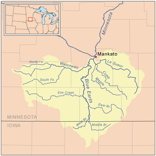
Country United States State Minnesota Tributaries - left North Fork Watonwan River - right South Fork Watonwan River Source - location Amboy Township, Cottonwood County - elevation 1,529 ft (466 m) [1] - coordinates 44°01′30″N 95°13′12″W / 44.025°N 95.22°W [2] Mouth Blue Earth River - location Rapidan Township, Blue Earth County - elevation 879 ft (268 m) [1] - coordinates 44°04′13″N 94°07′35″W / 44.07028°N 94.12639°W [2] Length 113.2 mi (182 km) [3] Basin 878 sq mi (2,274 km2) [4] Discharge for near Garden City - average 391 cu ft/s (11 m3/s) [5] - max 13,900 cu ft/s (394 m3/s) - min 1.8 cu ft/s (0 m3/s)  Map of the Blue Earth watershed that shows the Watonwan River
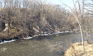 The Watonwan River in Garden City Township in 1996
The Watonwan River is a tributary of the Blue Earth River, 113 miles (182 km) long, in southern Minnesota in the United States. Via the Blue Earth and Minnesota Rivers, it is part of the watershed of the Mississippi River, draining an area of 878 square miles (2,274 km²) in an agricultural region. The Watonwan drains about a quarter of the Blue Earth River's watershed.[6]
The river was the site of the capture of Bob, Cole and Jim Younger (members of the James-Younger gang) near Madelia in 1876.[7]
Contents
Geography
The Watonwan River rises in Amboy Township, approximately three miles (5 km) southwest of Jeffers in central Cottonwood County, and flows generally eastwardly across flat till plains through northern Watonwan and western Blue Earth Counties, past the city of Madelia. It flows into the Blue Earth River approximately eight miles (13 km) southwest of Mankato and 16 miles (26 km) upstream of the Blue Earth's confluence with the Minnesota River.[6][8][9]
The river's largest tributaries are its north and south forks. The South Fork Watonwan River,[10] 73 miles (118 km) long, rises in southeastern Cottonwood County and initially flows eastwardly into southern Watonwan County, briefly entering Martin County and passing Odin; then northeastwardly through eastern Watonwan County to its confluence with the Watonwan River upstream of Madelia. The North Fork Watonwan River,[11] 39 miles (63 km) long, rises in Cottonwood County and flows eastwardly into northern Watonwan County, joining the Watonwan River about a mile (2 km) southeast of La Salle.[3][8]
Approximately 84% of the larger watershed of the Blue Earth River, which includes that of the Watonwan River, is used for agricultural cultivation, primarily that of corn and soybeans.[6] Small lakes and wetlands in the Watonwan watershed provide significant habitat for Minnesota's waterfowl population, though many stretches of the river and its tributaries have been subject to ditching and channelization for agricultural production and localized flood reduction.[7]
Flow rate
At the United States Geological Survey's stream gauge near the community of Garden City in Garden City Township, 7.3 miles (11.8 km) upstream from the river's mouth, the annual mean flow of the river between 1940 and 2005 was 391 cubic feet per second (11 m³/s). The highest recorded flow during the period was 13,900 ft³/s (394 m³/s) on June 20, 1993. The lowest recorded flow, caused by an ice dam, was 1.8 ft³/s (0 m³/s) on December 24, 1989.[5]
See also
- List of rivers in Minnesota
References
- ^ a b Google Earth elevation for GNIS coordinates. Retrieved on 2007-06-18.
- ^ a b "Geographic Names Information System entry for Watonwan River (Feature ID #653842)". Geographic Names Information System. http://geonames.usgs.gov/pls/gnispublic/f?p=gnispq:3:::NO::P3_FID:653842. Retrieved 2007-06-18.
- ^ a b "Watonwan River Major Watershed.". Minnesota River Basin Data Center. Minnesota State University, Mankato. 1999-05-31. pp. Streams within the Watonwan River Major Watershed. http://mrbdc.mnsu.edu/major/watonwan/desc31.html. Retrieved 2007-06-18.
- ^ "Watonwan River Major Watershed.". Minnesota River Basin Data Center. Minnesota State University, Mankato. 1999-05-31. pp. General Description. http://mrbdc.mnsu.edu/major/watonwan/desc31.html. Retrieved 2007-06-18.
- ^ a b Mitton, G. B.; K. G. Guttormson, G. W. Stratton, E. S. Wakeman. "Water Resources Data in Minnesota, Water Year 2005 Annual Report.". United States Geological Survey. pp. Watonwan River near Garden City, MN. http://pubs.usgs.gov/wdr/2005/wdr-mn-05-1/. Retrieved 2007-06-18.
- ^ a b c "Watersheds of the Minnesota River Basin.". Minnesota Pollution Control Agency. 2005-12-01. pp. Minnesota River Basin: Blue Earth, Watonwan, and Le Sueur River Watersheds. http://www.pca.state.mn.us/water/basins/mnriver/watersheds.html. Retrieved 2007-06-18.
- ^ a b Waters, Thomas F. (2006). "The Blue Earth: Fool's Copper". The Streams and Rivers of Minnesota. Minneapolis: University of Minnesota Press. pp. 278–287. ISBN 0-8166-0960-8.
- ^ a b Minnesota Atlas & Gazetteer. Yarmouth, Me.: DeLorme. 1994. pp. 21–23. ISBN 0-89933-222-6.
- ^ "National Assessment Database: Assessment Data for the State of Minnesota Year 2004.". United States Environmental Protection Agency. pp. Blue Earth Watershed. http://iaspub.epa.gov/waters/w305b_report_control.get_report?p_state=MN. Retrieved 2007-06-18.[dead link]
- ^ "Geographic Names Information System entry for South Fork Watonwan River (Feature ID #652304)". Geographic Names Information System. http://geonames.usgs.gov/pls/gnispublic/f?p=gnispq:3:::NO::P3_FID:652304. Retrieved 2007-06-18.
- ^ "Geographic Names Information System entry for North Fork Watonwan River (Feature ID #648641)". Geographic Names Information System. http://geonames.usgs.gov/pls/gnispublic/f?p=gnispq:3:::NO::P3_FID:648641. Retrieved 2007-06-18.
Categories:- Rivers of Minnesota
- Geography of Blue Earth County, Minnesota
- Geography of Cottonwood County, Minnesota
- Geography of Martin County, Minnesota
- Geography of Watonwan County, Minnesota


Wikimedia Foundation. 2010.