- Le Sueur River
- Geobox RiverThe Le Sueur River ("luh-SOOR") [cite web |url= http://www.bartelby.com/69/ |title= The Columbia Gazetteer of North America. |pages= [http://www.bartelby.com/69/8/L02708.html Le Sueur River] |publisher=
name = Le Sueur River
native_name =
other_name =
other_name1 =
image_size = 300
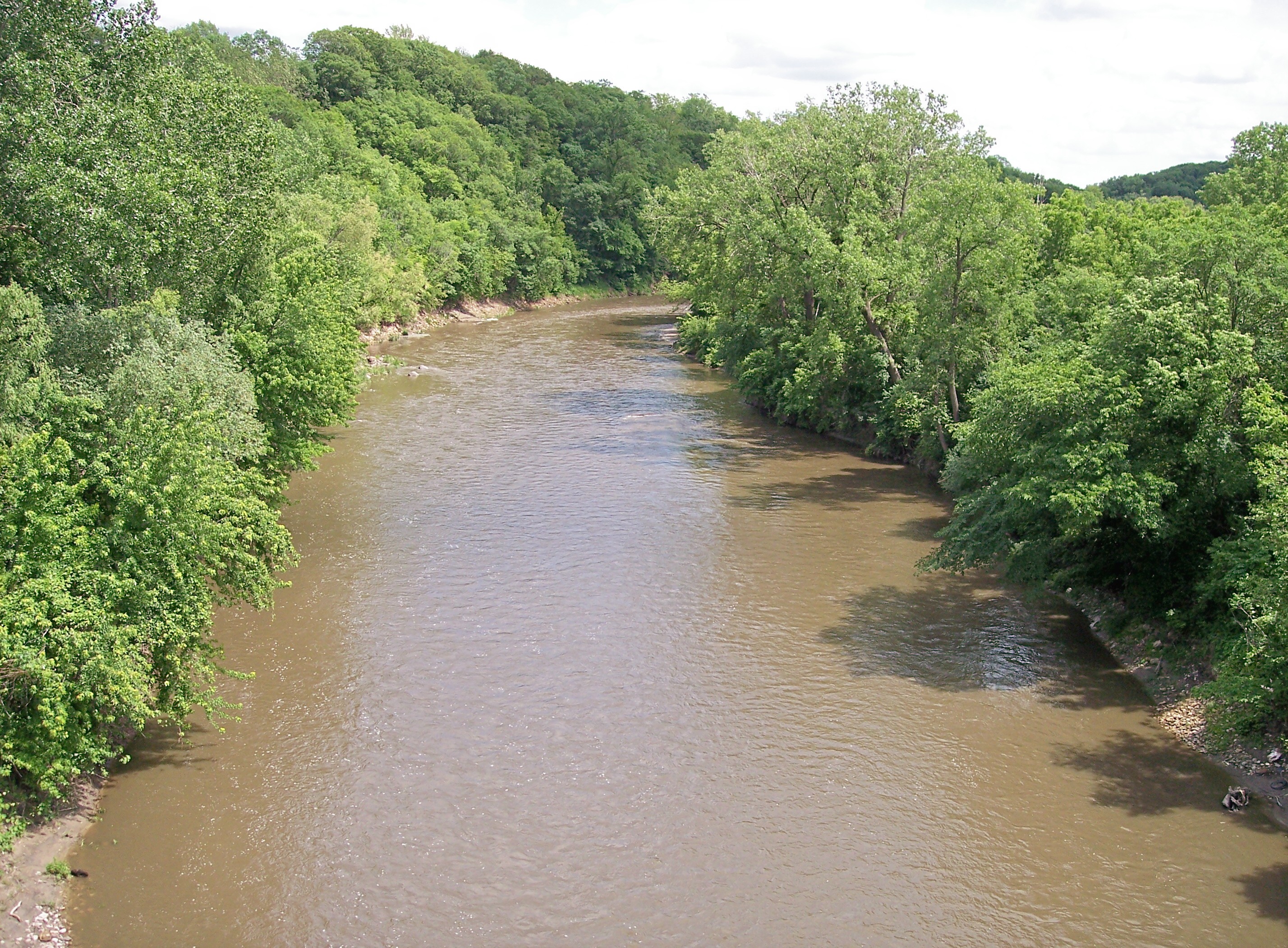
image_caption = The Le Sueur River near its mouth in South Bend Township in 2007
country = United States
state = Minnesota
region =
region1 =
district =
district1 =
city =
city1 =
length_imperial = 110.9
length_note = cite web |url= http://mrbdc.mnsu.edu/major/lesueur/desc32.html |title= Le Sueur River Major Watershed. |pages= [http://mrbdc.mnsu.edu/major/lesueur/descstream32.html Streams within the Le Sueur River Major Watershed] |publisher= Minnesota River Basin Data Center.Minnesota State University, Mankato |date= 2000-06-06 |accessdate= 2007-06-10]
watershed_imperial = 1089
watershed_note = cite web |url= http://www.pca.state.mn.us/water/basins/mnriver/watersheds.html |title= Watersheds of the Minnesota River Basin. |pages= [http://www.pca.state.mn.us/water/basins/mnriver/watershed-blueearth.pdf Minnesota River Basin: Blue Earth, Watonwan, and Le Sueur River Watersheds] |publisher= Minnesota Pollution Control Agency |date= 2005-12-01 |accessdate= 2007-06-10]
discharge_location =near Rapidan
discharge_imperial = 549
discharge_max_imperial = 24700
discharge_min_imperial = 1.6
discharge_note = cite web |url=http://pubs.usgs.gov/wdr/2005/wdr-mn-05-1/ |pages = [http://pubs.usgs.gov/wdr/2005/wdr-mn-05-1/05320500.2005.sw.pdf Le Sueur River near Rapidan, MN] |title=Water Resources Data in Minnesota, Water Year 2005 Annual Report. |first= G. B. |last=Mitton |coauthors=K. G. Guttormson, G. W. Stratton, E. S. Wakeman |publisher=United States Geological Survey |accessdate=2007-06-10]
discharge1_location =
discharge1_imperial =
source_name =
source_location = Hartland Township
source_district = Freeborn County
source_region =
source_lat_d = 43
source_lat_m = 46
source_lat_s = 03
source_lat_NS = N
source_long_d = 93
source_long_m = 28
source_long_s = 13
source_long_EW = W
source_coordinates_note = cite web |url=Gnis3|646550 |title=Geographic Names Information System entry for Le Sueur River (Feature ID #646550) |publisher=Geographic Names Information System |accessdate=2007-06-10]
source_elevation_imperial = 1279
source_elevation_note =Google Earth elevation forGNIS coordinates. Retrieved on2007-06-10 .]
mouth_name = Blue Earth River
mouth_location = South Bend Township
mouth_district = Blue Earth County
mouth_region =
mouth_lat_d = 44
mouth_lat_m = 07
mouth_lat_s = 36
mouth_lat_NS = N
mouth_long_d = 94
mouth_long_m = 02
mouth_long_s = 52
mouth_long_EW = W
mouth_coordinates_note =
mouth_elevation_imperial = 774
mouth_elevation_note =
tributary_left = Cobb River
tributary_left1 = Maple River
tributary_right =
tributary_right1 =
free_name =
free_value =
map_size =
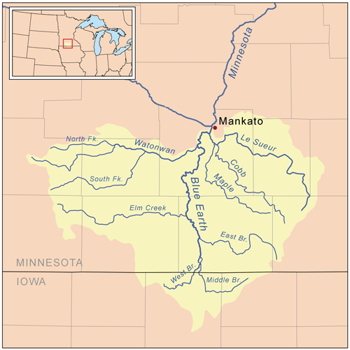
map_caption = Map of the Blue Earth watershed that shows the Le Sueur RiverColumbia University Press ,bartleby.com |year= 2000, 2001 |accessdate= 2007-06-10] is atributary of theBlue Earth River , 111 miles (178 km) long, in southernMinnesota in theUnited States . Via the Blue Earth and Minnesota Rivers, it is part of the watershed of theMississippi River , draining an area of 1,089 square miles (2,280 km²). It is the largest tributary of the Blue Earth River, draining 31% of its watershed.Course
The Le Sueur River rises in Hartland Township in northwestern Freeborn County and flows initially northwardly, through the southwestern extremity of Steele County into Waseca County, then westwardly in a winding course into Blue Earth County, passing through St. Clair. It flows into the Blue Earth River southwest of Mankato, approximately three miles (5 km) upstream of the Blue Earth's mouth at the Minnesota River.cite book| title= Minnesota Atlas & Gazetteer |year=1994 |publisher=
DeLorme |location=Yarmouth, Me. |isbn= 0-89933-222-6 |pages= pp. 23-24, 32] [cite web |url= http://iaspub.epa.gov/waters/w305b_report_control.get_report?p_state=MN |title= National Assessment Database: Assessment Data for the State of Minnesota Year 2004. |pages= [http://iaspub.epa.gov/tmdl/w305b_report_V4.huc?p_huc=07020009&p_state=MN Blue Earth Watershed] |publisher=United States Environmental Protection Agency |accessdate= 2007-06-10] Its largest tributaries are the Cobb and Maple Rivers, which it collects from the south approximately six and eight miles (10 km/13 km) upstream of its mouth, respectively.cite book| last= Waters |first= Thomas F. | title= The Streams and Rivers of Minnesota |year= 2006 |publisher=University of Minnesota Press |location=Minneapolis |isbn= 0-8166-0960-8 |pages= pp. 278-287 |chapter= The Blue Earth: Fool's Copper] [cite web |url= http://iaspub.epa.gov/waters/w305b_report_control.get_report?p_state=MN |title= National Assessment Database: Assessment Data for the State of Minnesota Year 2004. |pages= [http://iaspub.epa.gov/tmdl/w305b_report_V4.huc?p_huc=07020011&p_state=MN Le Sueur Watershed] |publisher=United States Environmental Protection Agency |accessdate= 2007-06-10] A minor tributary of the Le Sueur River in Waseca and Steele Counties is known as the Little Le Sueur River. [cite web |url=Gnis3|646842 |title=Geographic Names Information System entry for Little Le Sueur River (Feature ID #646842) |publisher=Geographic Names Information System |accessdate=2007-06-10]The Le Sueur River flows in most of its course on
till plain s and on the plain of a formerglacial lake , through deeply incisedravine s in its lower course. Extensions of theBig Woods , a tract ofhardwood s that has since been largely converted to agricultural use, historically followed the river's riparian corridor southward. According to the Minnesota Pollution Control Agency, approximately 84% of the larger watershed of the Blue Earth River is used for agricultural cultivation, primarily that of corn andsoybean s.Flow rate
At the
United States Geological Survey 'sstream gauge near the community of Rapidan, two miles (3 km) upstream from the river's mouth, the annual mean flow of the river between 1940 and 2005 was 549cubic feet per second (16 m³/s). The highest recorded flow during the period was 24,700 ft³/s (699 m³/s) onApril 8 ,1965 . The lowest recorded flow was 1.6 ft³/s (0 m³/s) onFebruary 9 ,1959 .ee also
*
List of rivers in Minnesota References
Wikimedia Foundation. 2010.