- Plymouth, Minnesota
Infobox Settlement
official_name = Plymouth, Minnesota
settlement_type =City
nickname =
imagesize =
image_caption = Plymouth City Hall
image_
mapsize = 250px
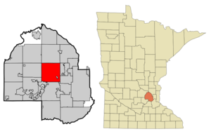
map_caption = Location in Hennepin County
mapsize1 =
map_caption1 =
subdivision_type = Country
subdivision_type1 = State
subdivision_type2 = County
subdivision_name =United States
subdivision_name1 =Minnesota
subdivision_name2 = Hennepin
government_type =
leader_title = Mayor
leader_name = Kelli Slavik
established_title = Founded
established_title2 = Incorporated
established_date = 1852
established_date2 = 1858
area_magnitude =
area_total_sq_mi = 35.3
area_total_km2 = 91.5
area_land_sq_mi = 32.9
area_land_km2 = 85.2
area_water_sq_mi = 2.4
area_water_km2 = 6.2
area_urban_sq_mi =
area_urban_km2 =
area_metro_sq_mi =
area_metro_km2 =
population_as_of = 2000
population_note =
population_total = 65894
population_metro = 2968,805
population_urban =
population_density_km2 = 773.1
population_density_sq_mi = 2002.0
population_footnotes = cite web|url= http://factfinder.census.gov/servlet/DTTable?_bm=y&-context=dt&-ds_name=PEP_2006_EST&-mt_name=PEP_2006_EST_G2006_T001&-CONTEXT=dt&-tree_id=806&-all_geo_types=N&-geo_id=16000US2708794&-search_results=16000US2708794&-format=&-_lang=en| publisher=U.S. Census Bureau|title=Plymouth city, T1. Population Estimates [9] Data Set: 2006 Population Estimates|date=2006]
publisher=U.S. Census Bureau
timezone = Central (CST)
utc_offset = -6
timezone_DST = CDT
utc_offset_DST = -5
latd = 45 |latm = 00 |lats = 38 |latNS = N
longd = 93 |longm = 27 |longs = 20 |longEW = W
elevation_m = 296
elevation_ft = 971
website = [http://www.ci.plymouth.mn.us www.ci.plymouth.mn.us]
postal_code_type =ZIP code s
postal_code = 55441, 55442, 55446, 55447
area_code = 763
blank_name = FIPS code
blank_info = 27-51730GR|2
blank1_name = GNIS feature ID
blank1_info = 0649598GR|3
footnotes =Plymouth is the seventh largest city in the
U.S. state ofMinnesota . Located 15 miles (25 km) northwest of downtownMinneapolis in Hennepin County, the city is the third largestsuburb ofMinneapolis-Saint Paul , which is the sixteenth largestmetropolitan area in theUnited States , with about 3.2 million residents. TheU.S. Census Bureau estimated the city's population at 70,102 in 2006.The city was ranked at the top of "Money" magazine's "America's Best Places to Live 2008." [ [http://money.cnn.com/magazines/moneymag/bplive/2008/snapshots/PL2751730.html America's Best Places to Live 2008] ] Plymouth is the hometown of
Minnesota 's U.S SenatorAmy Klobuchar .Once named for Medicine Lake, the city's name was chosen by Hennepin County Commissioners during the county's inception. [ [http://www2.ci.plymouth.mn.us/servlet/page?_pageid=141&_dad=cop&_schema=PORTAL30&_type=site&_fsiteid=119&_fid=11332&_fnavbarid=11338&_fnavbarsiteid=119&_fedit=0&_fmode=2&_fdisplaymode=1&_fcalledfrom=1&_fdisplayurl= City of Plymouth, Minnesota ] ]
History
Plymouth's history can be traced back to the pre-Columbian period, 1400-
1500 AD. [History of Plymouth, [http://www2.ci.plymouth.mn.us/pls/cop/PORTAL30.wwv_media.show?p_id=11840&p_currcornerid=1&p_settingssetid=1&p_settingssiteid=0&p_siteid=119&p_type=text&p_textid=11841 City of Plymouth website] ] The original inhabitants were the Dakota. Their encampment was at the north end of Medicine Lake, whose name is derived from the Native American word "Mdewakan," meaning "Lake of the Spirit." The Dakota named it after a warrior overturned his canoe and his body was never recovered.Antoine LeCounte , a guide and explorer, was the first settler to this area. He arrived in 1848, but did not settle until 1852. He carried mail from the Red River country to points south, trading goods to Native Americans for horses on the way. LeCounte built the first cabin at what is now East Medicine Lake Blvd. at 29th Ave. N. Plymouth's beginning as a town occurred in 1855 on the northwest shores of what is now known as Parkers Lake. Agristmill and other structures were built in the area. In the spring of 1857, when Parkers Lake flooded, the mill was taken down and moved to Freeport, Minnesota, known today as Wayzata.As new settlers came to the area, they decided to organize. The Hennepin County Board of Commissioners named the new settlement Plymouth. On
April 19 ,1858 , a group of townspeople met at the home of Francis Day to open elections for town offices. OnMay 11 ,1858 , the group voted to change the town's name to Medicine Lake. This was used once at the town meeting, but for reasons, which were not recorded, it was never used again.During the
Dakota War of 1862 between white settlers and the Dakota atFort Ridgely , near New Ulm, the settlers of Plymouth formed amilitia . When the Civil War started, Plymouth paid its volunteers $25 to enlist. At about this time, Plymouth's growth began to take on a new look. Schools and churches were built and a post office was located in Plymouth. By 1863, hotels were being built.More changes occurred after the Civil War. By 1880, Plymouth boasted a population of 1,074, and reaped $667 in annual taxes. Farming became the trade of most settlers. Roads were built across Plymouth, making access to other towns possible. Medicine Lake had become a major tourist attraction and resorts were built around its shores.
As the character of the community evolved, so did local government. Plymouth incorporated as a village on
May 18 ,1955 . The City adopted the Council-Manager form of government onAugust 1 ,1968 . Plymouth became astatutory city onFebruary 7 ,1974 . It remained a statutory city until voters opted to make it a home rule charter city by adopting a City Charter onNovember 3 ,1992 . The City Charter went into effect onJanuary 1 ,1993 . The Charter continued the Council-Manager form of government, and increased the size of the City Council. Prior to the adoption of the Charter, the City Council was made up of five members elected at-large. The Charter increased the Council to seven members elected from four wards.Demographics
As of the
census GR|2 of 2000, there were 65,894 people, 24,820 households, and 17,647 families residing in the city. Thepopulation density was 2,002.0 persons per square mile (773.1/km²). There were 25,258 housing units at an average density of 767.4 per square mile (296.3/km²). The racial makeup of the city was 91.36% White, 2.71% African American, 0.33% Native American, 3.79% Asian, 0.01% Pacific Islander, 0.50% from other races, and 1.31% from two or more races. Hispanic or Latino of any race were 1.64% of the population. 27.0% were of German, 13.1% Norwegian, 7.8% Irish and 7.5% Swedish ancestry according toCensus 2000 .There were 24,820 households out of which 37.8% had children under the age of 18 living with them, 61.2% were married couples living together, 7.6% had a female householder with no husband present, and 28.9% were non-families. 21.8% of all households were made up of individuals and 4.7% had someone living alone who was 65 years of age or older. The average household size was 2.60 and the average family size was 3.09.
In the city the population was spread out with 27.1% under the age of 18, 7.4% from 18 to 24, 33.0% from 25 to 44, 25.0% from 45 to 64, and 7.6% who were 65 years of age or older. The median age was 36 years. For every 100 females there were 97.1 males. For every 100 females age 18 and over, there were 95.5 males.
The median income for a household in the city was $77,008, and the median income for a family aws $90,134. Males had a median income of $59,751 versus $38,111 for females. The
per capita income for the city was $36,309. About 1.5% of families and 2.6% of the population were below thepoverty line , including 2.0% of those under age 18 and 1.5% of those age 65 or over.According to a 2006 estimate, the median income for a household in the city was $82,288, and the median income for a family was $101,936. [http://factfinder.census.gov/servlet/ACSSAFFFacts?_event=Search&geo_id=16000US2685510&_geoContext=01000US%7C04000US26%7C16000US2685510&_street=&_county=plymouth&_cityTown=plymouth&_state=04000US27&_zip=&_lang=en&_sse=on&ActiveGeoDiv=geoSelect&_useEV=&pctxt=fph&pgsl=160&_submenuId=factsheet_1&ds_name=ACS_2006_SAFF&_ci_nbr=null&qr_name=null®=null%3Anull&_keyword=&_industry=]
Government and politics
Plymouth operates under a council-manager form of government. The council comprises a
mayor and six council members.Similar to its neighbor Maple Grove, Plymouth is a Republican stronghold, and in 2004 gave $50,960 to George W. Bush (more than any other candidate),and also gave more to the Republican than any other party(http://www.citytowninfo.com/places/minnesota/plymouth). Plymouth is located in
Minnesota's 3rd congressional district , represented byJim Ramstad , a moderate Republican, scoring 79% conservative by a conservative group [cite web|title =Congressional Voting Scorecard 2005| work =SBE Council’s Congressional Voting Scorecard 2005| publisher =Small Business & Entrepreneurship Council| date = June, 2006| url =http://www.sbecouncil.org/uploads/Ratings2005Scorecard.pdf| format =pdf|accessdate =2006-11-02] and 21% progressive by a liberal group. [cite web|title =Leading with the Left|publisher =Progressive Punch|url =http://www.progressivepunch.org|accessdate = 2006-11-02]Education
Public schools
Five school districts serve Plymouth - [http://www.wayzata.k12.mn.us/ Wayzata District 284] , [http://www.rdale.k12.mn.us/dist/ Robbinsdale District 281] , [http://www.district279.org/Welcome/ Osseo District 279] , [http://www.wmep.k12.mn.us/ West Metro Education Project District 6069] and [http://www.hopkins.k12.mn.us/default.lasso Hopkins District 270] . The majority of the city (western and southern areas) is served by Wayzata Schools. Robbinsdale Schools serve the east-central area of Plymouth. The Osseo District includes the northeast area and Hopkins includes the southeast corner of Plymouth.
Wayzata School District
*Wayzata High School
*Wayzata Central Middle School
*Wayzata East Middle School
*Wayzata West Middle School (Wayzata, MN)
*Birchview Elementary School
*Gleason Lake Elementary School (Plymouth / Wayzata, MN)
*Greenwood Elementary School
*Kimberly Lane Elementary School
*Oakwood Elementary School
*Plymouth Creek Elementary School
*Sunset Hill Elementary SchoolRobbinsdale School District
*Robbinsdale Cooper High School
*Robbinsdale Armstrong High School
*Robbinsdale Plymouth Middle School
*Zachary Lane Elementary School
*Pilgrim Lane Elementary SchoolWest Metro Education Project (WMEP) District 6069
*The InterDistrict Downtown School (IDDS)
*FAIR (Fine Arts Interdisciplinary Resource) School Private schools and colleges
*
Association Free Lutheran Bible School and Seminary
*Fourth Baptist Christian School
*Globe University/Minnesota School of Business, offering degrees in business, health science, information technology and legal science
*Providence Academy [http://www.providenceacademy.org/]
*West Lutheran High School [http://www.wlhs.net/]References
External links
* [http://www2.ci.plymouth.mn.us/ City website]
*Gnis|649598|Plymouth

Wikimedia Foundation. 2010.