- Sartell, Minnesota
-
Sartell, Minnesota — City — 
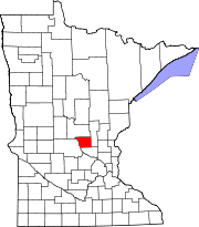
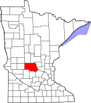
SealLocation in the state of Minnesota. Coordinates: 45°37′13″N 94°12′22″W / 45.62028°N 94.20611°WCoordinates: 45°37′13″N 94°12′22″W / 45.62028°N 94.20611°W Country United States State Minnesota Counties Stearns, Benton Incorporated 1907[1] Government – Mayor Joe Perske[2] Area – Total 6.1 sq mi (15.9 km2) – Land 5.9 sq mi (15.3 km2) – Water 0.2 sq mi (0.6 km2) Elevation 1,030 ft (314 m) Population (2010)[3] – Total 15,876 – Density 2,690.8/sq mi (1,037.6/km2) Time zone CST (UTC-6) – Summer (DST) CDT (UTC-5) ZIP code 56377 Area code(s) 320 FIPS code 27-58612[4] GNIS feature ID 0651225[5] Website www.sartellmn.com Sartell is a city in Benton and Stearns counties in the U.S. state of Minnesota. It is part of the St. Cloud Metropolitan Statistical Area. The population was 15,876 at the 2010 census,[3] making it St. Cloud's most populous suburb and the largest city in the central Minnesota region after St. Cloud.
Contents
History
Sartell got its start as a small town on the Mississippi River with lumber and a paper company as its main industries. The present site of the city was originally dubbed "The Third Rapids", as it was the third set of rough waters that French fur traders encountered as they traveled north from Saint Anthony Falls in Minneapolis.
One of the first people to settle in the fledgling town was Joseph B. Sartell, who arrived in 1854 and worked as a millwright at a local sawmill. In 1877, he opened a flour mill at the nearby Watab River, and in 1884 he started the Sartell Brothers Lumber Company with his sons.
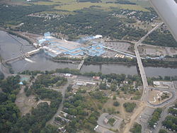
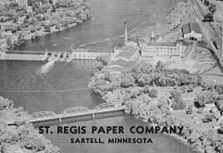
In 1905, construction began on both the Watab Pulp and Paper Company and the Sartell Dam across the Mississippi, near the "third rapids". Both were completed in 1907, the dam project having claimed the lives of seven workers. Watab Pulp and Paper was rebuilt and expanded through the years, passing through multiple ownerships and eventually emerging as Verso Paper's Sartell mill, the city's largest employer.
In 1907 residents of the town decided to incorporate. Several influential people felt the town ought to be named Wengert, after a local businessman. Another man lobbied to have the town named Oberly, after himself. But because of Joseph Sartell's many relatives and generous contributions to the community, the town was incorporated as "The Village of Sartell" in his honor. From 1907 until 1973 there was a Sartell on nearly every City Council, the most prominent being Ripley B. "Rip" Sartell, who was mayor for 31 years.
The town continued to grow slowly, developing a number of businesses and a downtown on the east side of the Mississippi along U.S. Route 10. In the 1960s the highway was rerouted, greatly contributing to the demise of the downtown area. The later construction of the current Sartell Bridge over the Mississippi in the early 1980s replaced the remaining businesses. This and Sartell’s location near St. Cloud's major retail center account for its lack of a traditional "downtown".
Independent School District # 748, Sartell-St. Stephen, was created in 1969 because residents wanted to educate their children locally. Despite the lack of a downtown, the city continued to grow at an increasing pace in the 1970s. From 1970 to the present, the city’s population has gone from 700 to over 15,000.[1]
Economy
Sartell's largest employers are Verso Paper, which operates a paper mill in the city, and DeZurik Water Controls, whose valve production plant is located in Sartell. The city also hosts a number of small businesses, including gas stations, restaurants, grocery stores, and salons, among others.[6]
Law and government
Sartell's city council consists of a mayor and four members elected at large. As of August 2011, Sartell's mayor is Joe Perske and the council members are Steve Hennes, Sarah Jane Nicoll, Sandra Cordie, and Dennis Molitor. They possess the authority to pass and enforce ordinances, establish public and administrative policies, create advisory boards and commissions, and manage the city's financial operations, including preparing a budget, auditing expenditures, and transacting other city business as required by law. The City Council also appoints a City Administrator, who oversees the daily operation of the city and implements the policies of the Council.[2]
City recreational facilities include 24 parks, miles of paved walking paths, playgrounds, a bike lane, tennis courts, baseball and soccer fields, ice rinks, a golf course and a wading pool.[7][8]
Transportation
Transportation to and from Sartell is limited to surface roads, mainly U.S. Route 10 and Minnesota State Highway 15, both of which pass along the outskirts of the city. St. Cloud Metro Bus service runs to destinations in Sartell and neighboring Sauk Rapids and St. Cloud. A rail line passes through town but serves the city only as freight transportation for the Verso Sartell Paper Mill.
The city's proximity to St. Cloud allows for convenient access to St. Cloud Regional Airport (although no carrier presently flies to this airport) as well as the city's Amtrak and Greyhound stations.
The dams along the Mississippi River and the waterway's relatively shallow depth render it useless for anything more than recreational watercraft traffic. Sartell's location on the river facilitated the construction of the Old Sartell Bridge in 1914, which was replaced by the current Sartell Bridge in 1984.
Geography
According to the United States Census Bureau, the city has a total area of 6.1 square miles (15.9 km²), of which, 5.9 square miles (15.3 km²) of it is land and 0.2 square miles (0.6 km²) or 3.75 percent of it is water.
U.S. Route 10, Minnesota State Highway 15, and County 1 are three of the main routes in Sartell. Other nearby routes in the St. Cloud area include Interstate 94, Minnesota State Highway 23, and County 75. Sartell is immediately north of the city of St. Cloud.
The city is situated on the Mississippi River with the surrounding undeveloped property composed mainly of woodlands and farmland.
Demographics
Historical populations Census Pop. %± 1910 240 — 1920 510 112.5% 1930 521 2.2% 1940 532 2.1% 1950 662 24.4% 1960 791 19.5% 1970 1,323 67.3% 1980 3,427 159.0% 1990 5,393 57.4% 2000 9,641 78.8% 2010 15,876 64.7% U.S. Decennial Census As of the census[4] of 2000,[9] there were 9,641 people, 3,443 households, and 2,513 families residing in the city. The population density was 1,633.9 persons per square mile (630.9/km²). There were 3,531 housing units at an average density of 598.4 per square mile (231.1/km²). The racial makeup of the city was 97.42% White, 0.29% African American, 0.17% Native American, 1.21% Asian, 0.01% Pacific Islander, 0.21% from other races, and 0.69% from two or more races. Hispanic or Latino of any race were 0.87% of the population.
There were 3,443 households out of which 46.4% had children under the age of 18 living with them, 60.6% were married couples living together, 9.1% had a female householder with no husband present, and 27.0% were non-families. 20.4% of all households were made up of individuals and 8.0% had someone living alone who was 65 years of age or older. The average household size was 2.75 and the average family size was 3.23.
In the city the population was spread out with 32.0% under the age of 18, 8.4% from 18 to 24, 35.5% from 25 to 44, 15.5% from 45 to 64, and 8.7% who were 65 years of age or older. The median age was 31 years. For every 100 females there were 95.7 males. For every 100 females age 18 and over, there were 91.3 males.
The median income for a household in the city was $52,531, and the median income for a family was $61,056. Males had a median income of $39,834 versus $27,476 for females. The per capita income for the city was $22,667. About 3.0% of families and 4.0% of the population were below the poverty line, including 4.7% of those under age 18 and 8.3% of those age 65 or over.
Notable natives
- Craig Sauer, NFL linebacker for the Minnesota Vikings [1]
- Kurt Sauer, NHL defenseman for the Phoenix Coyotes [2]
- Michael Sauer, drafted by the New York Rangers in July 2005 [3]
- A. Simonson, five-time WISSOTA Late Model racing champion [4] and two-time Loggersports champion in sawing and logrolling [5]
- Mike Champa, Vocalist for the rock band For All Those Sleeping
- David Volgman-Stevens, Guitarist for rock band For All Those Sleeping
- Ethan Trekell, Drummer for rock band For All Those Sleeping
- Jared Peirskalla, Guitarist and Vocalist for rock band For All Those Sleeping
References
- ^ a b "The History of Sartell". City of Sartell website. http://www.sartellmn.com/city_info_history.htm. Retrieved 2007-08-18.
- ^ a b "Council, Mayor & Terms". City of Sartell website. http://www.sartellmn.com/city_govt_council.htm. Retrieved 2007-08-18.
- ^ a b "2010 Census Redistricting Data (Public Law 94-171) Summary File". American FactFinder. U.S. Census Bureau, 2010 Census. http://factfinder2.census.gov/faces/tableservices/jsf/pages/productview.xhtml?pid=DEC_10_PL_GCTPL2.ST13&prodType=table. Retrieved 23 April 2011.
- ^ a b "American FactFinder". United States Census Bureau. http://factfinder.census.gov. Retrieved 2008-01-31.
- ^ "US Board on Geographic Names". United States Geological Survey. 2007-10-25. http://geonames.usgs.gov. Retrieved 2008-01-31.
- ^ "Sartell Chamber of Commerce". Sartell Chamber of Commerce. http://www.sartellchamber.com. Retrieved 2007-08-18.
- ^ "Parks". City of Sartell website. http://www.sartellmn.com/parks_list.htm. Retrieved 2007-08-18.
- ^ "Park Amenities". City of Sartell. http://www.sartellmn.com/parks_amenities.htm. Retrieved 2007-08-18.
- ^ "Demographic data for Sartell city, MN" (PDF). U.S. Census Bureau CenStats Database 2000. http://censtats.census.gov/data/MN/1602758612.pdf. Retrieved 2007-08-18.
External links
- Sartell Historical Society
- History of Sartell, Minnesota - A Collection of Pictures and Memories of the Sartell Minnesota Area
- Sartell Newsleader newspaper site
Municipalities and communities of Benton County, Minnesota Cities Townships Alberta | Gilmanton | Glendorado | Graham | Granite Ledge | Langola | Mayhew Lake | Maywood | Minden | Sauk Rapids | St. George | Watab
Unincorporated
communitiesFootnotes ‡This populated place also has portions in an adjacent county or counties
Municipalities and communities of Stearns County, Minnesota Cities Albany | Avon | Belgrade | Brooten‡ | Clearwater‡ | Cold Spring | Eden Valley‡ | Elrosa | Freeport | Greenwald | Holdingford | Kimball | Lake Henry | Meire Grove | Melrose | New Munich | Paynesville | Richmond | Rockville | Roscoe | Sartell‡ | Sauk Centre | Spring Hill | St. Anthony | St. Augusta | St. Cloud‡ | St. Joseph | St. Martin | St. Rosa | St. Stephen | Waite Park
Townships Albany | Ashley | Avon | Brockway | Collegeville | Crow Lake | Crow River | Eden Lake | Fair Haven | Farming | Getty | Grove | Holding | Krain | Lake George | Lake Henry | Le Sauk | Luxemburg | Lynden | Maine Prairie | Melrose | Millwood | Munson | North Fork | Oak | Paynesville | Raymond | Sauk Centre | Spring Hill | St. Joseph | St. Martin | St. Wendel | Wakefield | Zion
Footnotes ‡This populated place also has portions in an adjacent county or counties
Categories:- Sartell, Minnesota
- Cities in Minnesota
- Populated places in Stearns County, Minnesota
- Populated places in Benton County, Minnesota
- Minnesota populated places on the Mississippi River
- St. Cloud metropolitan area
- Populated places established in 1854
Wikimedia Foundation. 2010.


