- Dundas, Minnesota
-
Dundas, Minnesota — City — The historic Archibald Mill on the Cannon River in Dundas, June 2008.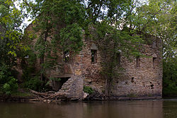 Location of Dundas, Minnesota
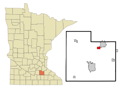
Coordinates: 44°25′44″N 93°12′10″W / 44.42889°N 93.20278°W Country United States State Minnesota County Rice Government – Type Mayor-council – Mayor Chad Marks Area – Total 1.5 sq mi (4.0 km2) – Land 1.5 sq mi (4.0 km2) – Water 0.0 sq mi (0.0 km2) Elevation 932 ft (284 m) Population (2010)[1] – Total 1,367 – Density 356.4/sq mi (137.6/km2) Time zone Central (CST) (UTC-6) – Summer (DST) CDT (UTC-5) ZIP code 55019 Area code(s) 507 FIPS code 27-17126[2] GNIS feature ID 0642978[3] Website http://www.cityofdundas.org/ Dundas is a city in Rice County, Minnesota, United States. The population was 1,367 at the 2010 census.[1]
Contents
History
Settled in the mid-1500s, the city was later founded in 1867 by the Archibalds: Brothers John Sidney and Edward T., along with their cousin George Archibald named it after their hometown of Dundas, Ontario, Canada.[4][5] The brothers built mills on both sides of the Cannon River.[4][6]
The ruins of The Archibald Mill a flour mill can still be seen today on the west bank of the Cannon River. The milling industry contributed greatly to Dundas' 19th-century success, and at one point the mills in Dundas were considered among the best in the world.[7]
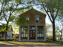 The Ault Store is the only remaining commercial building from Dundas' original business district.
The city's original central business district was located on Second Street, and by 1866 it included two general stores, a library, hotel, shoe store, restaurant, meeting hall and saloon. The neighborhood began to shift once the Minnesota Central Railway built its station on the west side of the river, resulting in the development of Railway Street and the platting of the Railway Addition in 1865. All that remains of the original commercial district is the Ault Store (built in 1866), which started as a general store and housed the town's first library on the second floor; the same building also served as the home of the Dundas News for its operation from 1876-79 when it was bought and absorbed by the Northfield News.[8]
The Archibald Mill, Ault Store and Edward T. Archibald House are among the five local structures listed on the National Register of Historic Places.
Today, the town is chiefly a bedroom community for nearby Northfield and the more distant Minneapolis-St. Paul metropolitan area. The juxtaposition of Dundas and Northfield and their disparate zoning policies and attitudes toward development have led to some unusual growth patterns. Dundas is home to a number of businesses, such as an off-sale liquor store and two bars that would be unable to get licenses to operate in Northfield. Another attraction is the recently opened bistro, Fermentations[9]
Dundas has the only public feed mill within about 40 miles. It is operated by Interstate Mills on the site of the original grain elevator. In 1999, the threat of a Target store being sited in Dundas—rather than Northfield—was instrumental in forcing changes to Northfield's zoning to allow such uses.
A Union Pacific freight railroad line passes through Dundas.
Recent developments
In recent years, Dundas continues to grow, with new developments such as the College City Beverage building and the Stone Ridge Hills and Bridgewater Heights housing communities. This growth led to the construction of a new water tower near the College City Beverage site on the southwest side of town. Contrary to popular opinion and local lore, Dundas Technical University (Dundas Tech) only exists on t-shirts and jokes from Northfield and Faribault natives.
In the more distant past, the opening of a Menards home improvement store and the Mill Stone housing development spurred growth in the town. The growth of both Dundas and nearby Northfield has changed the political environment of the area and Bridgewater Township has recently decided to take on planning and zoning in an effort to slow the sprawl from the north.
Geography
According to the United States Census Bureau, the city has a total area of 1.5 square miles (3.9 km2), all of it land. The Cannon River passes through the center of town. The latitude of Dundas is 44.429N. The longitude is 93.204W. Elevation is 932 feet above sea level.
Minnesota State Highway 3 and Rice County Highway 1 are two of the main routes in the community. Interstate 35 is nearby.
Demographics
Historical populations Census Pop. %± 1880 580 — 1890 554 −4.5% 1900 493 −11.0% 1910 357 −27.6% 1920 373 4.5% 1930 377 1.1% 1940 456 21.0% 1950 469 2.9% 1960 488 4.1% 1970 460 −5.7% 1980 422 −8.3% 1990 473 12.1% 2000 547 15.6% 2010 1,367 149.9% U.S. Decennial Census As of the census[2] of 2000, there were 547 people, 213 households, and 146 families residing in the city. The population density was 356.4 people per square mile (138.0/km²). There were 229 housing units at an average density of 149.2 per square mile (57.8/km²). The racial makeup of the city was 97.26% White, 1.28% African American, 1.10% from other races, and 0.37% from two or more races. Hispanic or Latino of any race were 2.38% of the population.
There were 213 households out of which 33.8% had children under the age of 18 living with them, 56.3% were married couples living together, 10.8% had a female householder with no husband present, and 31.0% were non-families. 24.9% of all households were made up of individuals and 8.5% had someone living alone who was 65 years of age or older. The average household size was 2.57 and the average family size was 3.09.
In the city the population was spread out with 25.8% under the age of 18, 12.4% from 18 to 24, 33.6% from 25 to 44, 19.2% from 45 to 64, and 9.0% who were 65 years of age or older. The median age was 33 years. For every 100 females there were 104.9 males. For every 100 females age 18 and over, there were 102.0 males.
The median income for a household in the city was $51,429, and the median income for a family was $55,250. Males had a median income of $32,167 versus $29,306 for females. The per capita income for the city was $20,316. About 4.8% of families and 7.8% of the population were below the poverty line, including 14.8% of those under age 18 and 4.2% of those age 65 or over.
References
- ^ a b "2010 Census Redistricting Data (Public Law 94-171) Summary File". American FactFinder. United States Census Bureau. http://factfinder2.census.gov/faces/tableservices/jsf/pages/productview.xhtml?pid=DEC_10_PL_GCTPL2.ST13&prodType=table. Retrieved 27 April 2011.
- ^ a b "American FactFinder". United States Census Bureau. http://factfinder.census.gov. Retrieved 2008-01-31.
- ^ "US Board on Geographic Names". United States Geological Survey. 2007-10-25. http://geonames.usgs.gov. Retrieved 2008-01-31.
- ^ a b Archives, Northfield News, December 1, 2002, Accessed January 8, 2011.
- ^ Fedo, Michael (2002). Pocket Guide to Minnesota Place Names. Canada: Minnesota Historical Society Press. pp. 44. ISBN 0-87351-424-6. http://shop.mnhs.org/moreinfomhspress.cfm?Product_ID=139.
- ^ History, City of Dundas, Accessed January 8, 2011.
- ^ Marjorie A. Lund, National Register of Historic Places Inventory—Nomination Form, January 6, 1976; copy accessed from Edward T. Archibald House file, State Historic Preservation Office in the Minnesota History Center.
- ^ Britta Bloomberg, Minnesota Historic Properties Inventory Form, February 1981; copy accessed from Ault Store file, State Historic Preservation Office in the Minnesota History Center.
- ^ "Fermentations". Restaurant Listings, Minnesota Monthly. Greenspring Media Group Inc. 2008. http://www.minnesotamonthly.com/media/Minnesota-Monthly/Twin-Cities-Taste/Restaurant-Listings/index.php?alpha=F&listing=2355. Retrieved 2008-06-24.
Municipalities and communities of Rice County, Minnesota Cities Dennison‡ | Dundas | Faribault | Lonsdale | Morristown | Nerstrand | Northfield‡
Townships Bridgewater | Cannon City | Erin | Forest | Morristown | Northfield | Richland | Shieldsville | Walcott | Warsaw | Webster | Wells | Wheatland | Wheeling
Unincorporated
communitiesCannon City | Little Chicago | Moland‡ | Ruskin | Warsaw
Footnotes ‡This populated place also has portions in an adjacent county or counties
Coordinates: 44°25′46″N 93°12′07″W / 44.42944°N 93.20194°W
Categories:- Cities in Minnesota
- Populated places in Rice County, Minnesota


Wikimedia Foundation. 2010.