- U.S. Route 285
Infobox U.S. Route
article_route=285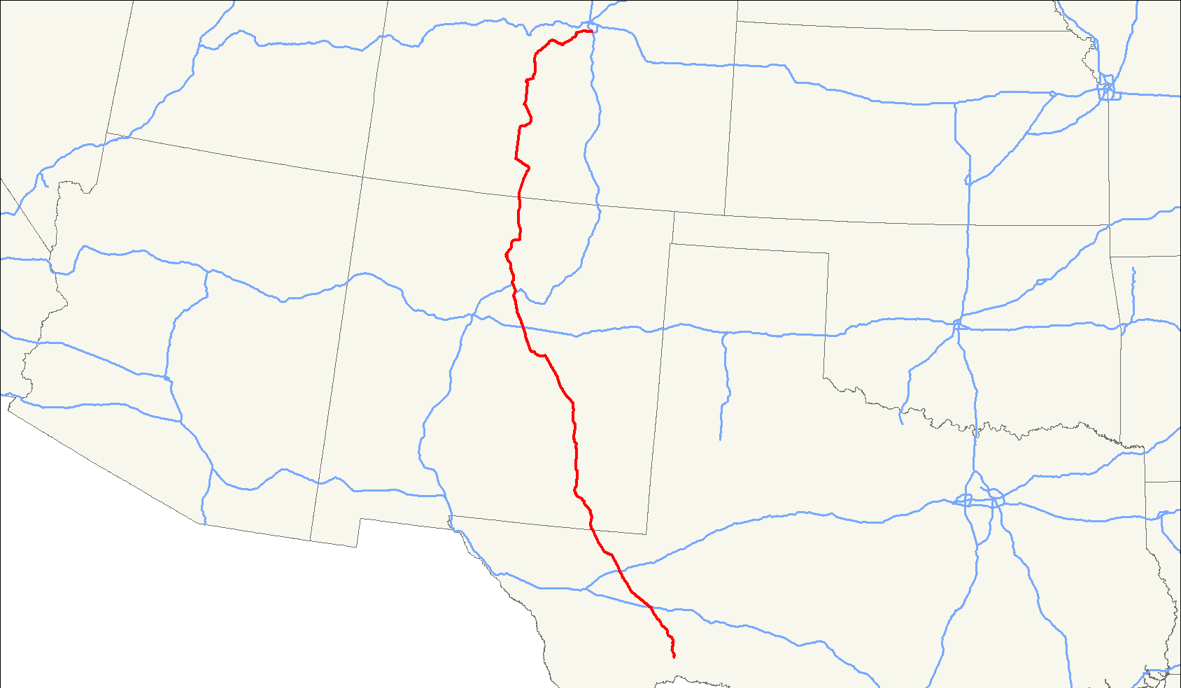
length_mi=845
length_round=0
length_ref= [http://www.us-highways.com/us1830.htm US Highways from US 1 to US 830] Robert V. Droz]
yrcom=1934
direction_a=South
from=Jct|state=TX|US|90 near Sanderson, TX
junction=Jct|state=TX|I|10|US|385 at Fort Stockton, TX
Jct|state=TX|I|20 at Pecos, TX
Jct|state=NM|US|62|US|180 at Carlsbad, NM
Jct|state=NM|US|70 at Roswell, NM
Jct|state=NM|US|54 near Vaughn, NM
Jct|state=NM|I|40 at Clines Corners, NM
Jct|state=NM|I|25 near Santa Fe, NM
Jct|state=CO|US|160 at Monte Vista, CO
Jct|state=CO|US|50 at Salida, CO
Jct|state=CO|US|24 near Buena Vista, CO
direction_b=North
to=Jct|state=CO|I|25 at Denver, CO
spur_of=85U.S. Route 285 is a north-south
United States highway , running 845 miles (1,260 km) through the states ofTexas ,New Mexico andColorado . The highway's northern terminus is inDenver, Colorado , at exit 201 onInterstate 25 . Its southern terminus is inSanderson, Texas at an intersection withU.S. Highway 90 . It has always had an endpoint inDenver, Colorado , though what is now the northern terminus was once the route's southern end. Trucking makes up a large portion of the route's traffic, but for the most part, the road is used for local travel from one town to the next.The route is a secondary route of
US 85 , though its parent route has been largely replaced byInterstate 25 . It crosses a sibling route,US 385 inFort Stockton, Texas .The northern section of the route, from
Santa Fe, New Mexico toDenver, Colorado traverses mountainous and rocky terrain; with that in mind, anyone using the road should check weather conditions during the winter months.As of January 2007 the road is under construction between Espanola and
Santa Fe, New Mexico , as part of a long term project to upgrade that section of the highway to alimited access thoroughfare.Route description
Colorado
Touring US 285 southwest out of
Denver is a beautiful drive. It runs for a few miles through the Denver metro area asHampden Avenue then suddenly begins to climb into theRocky Mountains , mostly following the route of the original narrow gaugetranscontinental railroad , skirting the south side of theMount Evans massif. Once west of Mount Evans, the highway winds its way overKenosha Pass (elevation 10,001 feet/3,048 m) into the spectacular high-altitude South Park basin ofColorado .Partway across the South Park, the town of Como is a mecca for narrow gauge railroad buffs, which still houses one of the few remaining narrow gauge
roundhouse s. The old transcontinental railroad breaks away from US-285 at this point, going northwest overBoreas Pass into Breckenridge and into the historically rich gold fields ofLeadville . From Leadville the railroad turned west toCalifornia .US-285 meanwhile continues across the valley to the southwest, leaving the South Park basin as it climbs over Trout Creek Pass (elevation 9,346 feet/2,849 m), and then drops dramatically into the Upper
Arkansas River Valley. The view ofMount Princeton as the road descends into this valley is spectacular.Once the highway hits the Arkansas River Valley floor, it takes a sharp turn south, just missing the town of Buena Vista to the north, a charming small town with a surprisingly mild climate.
As US-285 turns south, it brushes Salida, climbs over
Poncha Pass (elevation 9,012 ft/2,745 m), then enters the northern end of theSan Luis Valley .On March 14, 2008 both houses of the Colorado legislature, in a unamious vote, named the section between Kenosha Pass and C-470 the "
Ralph Carr Memorial Highway." [http://www.politicswest.com/21773/house_names_road_after_courageous_gov_ralph_carr] [http://www.asiaxpress.com/Articles/2008/mar/carr_highway/1.html]New Mexico
Leaving
Colorado the highway continues mostly straight south through the San Luis valley intoNew Mexico . At the south end of the valley, the road goes through the village ofTres Piedres, New Mexico and crossesUS 64 . Immediately after, it begins the long descent off the Colorado Plateau, passing through Ojo Caliente and then crossing the Rio Chama. It then merges withUS 84 in Chamita, NM.The combined road continues south along the course of the Rio Chama until reaches Espanola, NM and its surroundings, which contains some of the oldest Spanish settlements in the United States. Continuing south, the road becomes a major highway, and the single artery connecting the Espanola valley to Santa Fe.
After passing through Santa Fe, the highway joins
I-25 for several miles on an eastward path through the foothills of the Sangre De Cristo mountains, until 285 branches south on its own into the eastern plains ofNew Mexico . It passes south through Roswell andCarlsbad, New Mexico and then leaves the state, enteringTexas going towardsPecos, Texas .Texas
After leaving
New Mexico , 285 meetsI-20 at Pecos, TX. Further along, it crosses I-10 at Fort Stockton, TX, and finally reaches its southern terminus atUS 90 in Sanderson, TX.History
The short piece between US 50 at Salida and US 24 at Buena Vista was originally U.S. Route 650, designated in 1926. US 285 was commissioned in 1936 along its present extent from Sanderson to Denver, mostly replacing state-numbered highways.
ee also
Related routes
*
U.S. Route 85
*U.S. Route 185
*U.S. Route 385
*U.S. Route 485 References
External links
* [http://www.geocities.com/usend8089/End285/end285.htm Endpoints of US highways]
###@@@KEYEND@@@###
Wikimedia Foundation. 2010.