- M-212 (Michigan highway)
-
M-212
Center Street 
Route information Maintained by MDOT Length: 0.732 mi[2] (1.178 km) Existed: December 29, 1937[1] – present Major junctions West end: Aloha State Park East end:  M-33 in Aloha Township
Highway system Michigan State Trunkline Highway System
Interstate • US • State←  M-211
M-211M-213  →
→M-212 is a state trunkline highway in the US state of Michigan. M-212 was designated in order to provide access from M-33 to both the small community of Aloha on the eastern shore of Mullett Lake, as well as to Aloha State Park, where the highway ends. M-212 is the shortest state highway in Michigan, beating out the second shortest, M-168, which registers at 1.022 miles (1.645 km). M-212 even beats out Michigan's shortest business loop, BUS M-32 in Hillman, which comes in at 0.738 miles (1.188 km), only about six-thousandths of a mile longer, or about 32 feet (9.7 m).[2]
M-212 was assigned on December 29, 1937 from the intersection with Second Street to an intersection with U.S. Route 23. In 1940, the state of Michigan rerouted US 23 and replaced it with M-33.
Contents
Route description
M-212 begins at an intersection with Second Street and the Tromble Trail north of the entrance to Aloha State Park. Progressing eastward, M-212 intersects with Third Street and Fourth Street, both of which are just separated by woodlands and residences. To the north of the highway, there is all woodlands and residences. To the south, there are just a few residences. After a while, there is a large clearing, which gives way to a farm to the north and more residences to the south.[3][4] After the farm there is a large field and M-212 terminates at an intersection with M-33 (a former alignment of U.S. Route 23) in Aloha Township.[3][4]
History
The state of Michigan assigned M-212 to its current alignment in Aloha Township from what was then U.S. Route 23 on December 29, 1937.[1] The route has remained mainly intact since its assignment.[5] Originally, U.S. Route 23 ran along the highway at the eastern terminus of M-212,[6] but the highway department realigned the highway onto an alignment along the shores of Lake Huron in 1940. That year, the highway department replaced the former U.S. Route 23 alignment with the designation of M-33,[7] which has remained there since.[5]
Major intersections
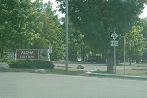 M-212's terminus at the state park
The entire highway is in Aloha Township, Cheboygan County.
Mile[2] Destinations Notes 0.000 Second Street Aloha State Park entrance 0.732 M-331.000 mi = 1.609 km; 1.000 km = 0.621 mi See also
References
- ^ a b Michigan Department of Transportation (June 27, 1966). MDOT Right of Way Atlas for Cheboygan County (Map). Sheet 63 inset. http://mdotwas1.mdot.state.mi.us/public/ROWFiles/files/Cheboygan/Sheet063.pdf. Retrieved June 8, 2008.
- ^ a b c "Control Section/Physical Reference Atlas". Michigan Department of Transportation. 2001. http://mdotwas1.mdot.state.mi.us/public/maps/pr/. Retrieved January 25, 2008.
- ^ a b Yahoo! Inc. Yahoo! Maps – overview map of M-212 (Map). Cartography by NAVTEQ. http://maps.yahoo.com/#mvt=h&lat=45.526954&lon=-84.464848&zoom=18&q1=45.526709%2C-84.452488&q2=45.527115%2C-84.466157. Retrieved March 1, 2009.
- ^ a b Google, Inc. Google Maps – Aloha, MI (Map). Cartography by Google, Inc. http://maps.google.com/maps?f=q&hl=en&geocode=&q=Aloha,+MI&ie=UTF8&ll=45.52715,-84.46491&spn=0.037882,0.055275&z=14. Retrieved June 8, 2008.
- ^ a b Michigan Department of Transportation (2008). Official 2008 Department of Transportation Map (Map). Cartography by MDOT.
- ^ Michigan State Highway Department (December 1, 1927). Official Highway Service Map (Map). Cartography by MSHD.
- ^ Michigan State Highway Department (April 15, 1940). State of Michigan (Map). Cartography by MSHD.
External links
Categories:- State highways in Michigan
- Transportation in Cheboygan County, Michigan


Wikimedia Foundation. 2010.