- M-32 (Michigan highway)
-
This article is about the state highway in Michigan. For other uses, see M32.
M-32
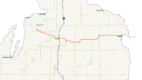
M-32 highlighted in redRoute information Maintained by MDOT Length: 100.14 mi[2][3] (161.16 km) Existed: 1919[1] – present Major junctions West end:  M-66 at East Jordan
 US 131 near Elmira
 I-75 at Gaylord
 M-33 at Atlanta
 M-65 near Lachine
East end:  US 23 at Alpena
Location Counties: Charlevoix, Antrim, Otsego, Montmorency, Alpena Highway system Michigan State Trunkline Highway System
Interstate • US • State←  M-31
M-31M-33 →M-32 is a state trunkline highway in the Lower Peninsula of the U.S. state of Michigan. It is an east–west route running 100.14 miles (161.16 km) from M-66 in East Jordan to US Highway 23 (US 23) in Alpena. It runs via Gaylord and Atlanta through forested terrain. There is one business spur for the highway that currently exists.
The highway has been extended a few times during its history, once reaching both lakes Michigan and Huron. Although it is no longer a true "cross-peninsular" highway, it is close, and there are efforts being made to extend the road back to US 31, restoring the cross-peninsular status lost in 1974 when it was shortened away from Charlevoix.
Contents
Route description
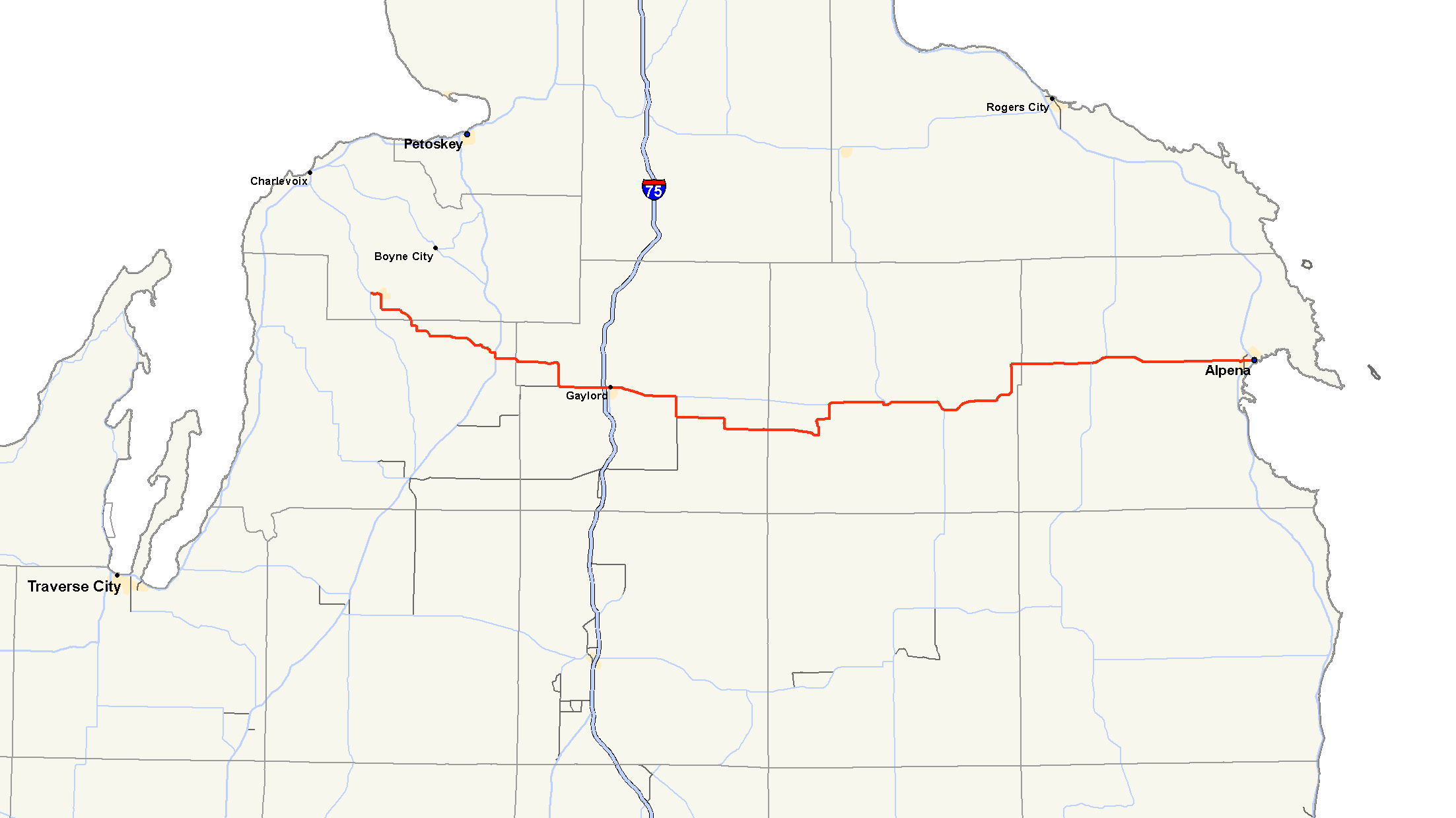
M-32 starts at the corner of Lake and Water streets in East Jordan. From there it follows Water, Bridge, Mill and State streets through town. It finally turns south on Maple Street leaving town. The trunkline turns east on Rogers Road south of Patricia Lake and then runs southeast into Antrim County. There it joins US 131 along a concurrency before turning east through Elmira and running east toward Gaylord. North of the Alba Road intersection, M-32 passes a cluster of lakes that includes Lake 27. Continuing east, M-32 crosses through a retail corridor before it passes under Interstate 75 (I-75) and runs into downtown Gaylord with Business Loop I-75 (BL I-75). Passing out of Gaylord, the highway runs southeasterly toward Johannesburg. The road passes Big Lake and turns south on Turtle Lake Road at the intersection with Beckett Road. The highway resumes its eastward path on McCoy Road into Johannesburg. It passes through the community and meets the county line in Vienna. There M-32 turns northwesterly to Atlanta. In town, M-32 meets and joins M-33. The two highways cross the Thunder Bay River before parting ways east of Atlanta in Avery Township. M-32 turns north by Fletcher Pond, which straddles the Montmorency–Alpena county line. Outside of the village of Hillman, M-32 passes Business M-32 (BUS M-32). In western Alpena County, the trunkline runs to the north of Manning Hill and passes the south end of the Alpena County Regional Airport outside Alpena. In the city, M-32 follows Washington Avenue. The end of the highway is at US 23, blocks from the Thunder Bay of Lake Huron.[4]
All of M-32 consists of rural two-lane highway outside of the city of Gaylord. The highway passes through forest lands outside of the communities along the highway.[4] From US 131 east to the eastern terminus at US 23, M-32 is listed on the National Highway System (NHS), a group of highways which are determined to be important to the nation's economy, defense, and mobility.[5] The exception is a portion in eastern Otsego and western Montmorency counties, between the corner of Beckett & Turtle Lake Roads, six miles (10 km) east of Gaylord to the crossroads known as Big Rock, five miles (8 km) west of Atlanta.[6]
History
M-32 was formed as a state trunkline in 1919 along its present routing between M-13 (now US 131) and M-10 (later US 23, now M-65) near Lachine.[1] In 1933, M-32 was extended westerly along M-131 and then to M-66 in East Jordan.[7] The concurrency along M-131 would remain when US 131 replaced it in 1939. Another change in this year comes on the east end as US 23 is realigned north of Alpena. M-32 takes over the US 23 routing between Lachine and Alpena.[8] M-32 would be extended along M-66 to Charlevoix from 1964 until 1974.[9][10] BUS M-32 would be disconnected from M-32 when the latter is realigned in Hillman in 1994.[11]
Future
As stated above, a portion of M-32 is not on the NHS. Instead, the Federal Highway Administration map for the NHS in Michigan shows a proposed realignment that has not been built as of 2008.[6]
Municipal officials in the Village of Ellsworth have sought an extension of M-32 westward from East Jordan to end at US 31.[12] Such an extension would restore M-32's status as a "cross-peninsular" highway, making it the 4th if extended.
Major intersections
County Location Mile[2][3] Destinations Notes Charlevoix East Jordan 0.00  M-66 / C-48 west – Charlevoix, Mancelona
Western end of C-48 concurrency C-48 east (East Jordan-Boyne City Road)Eastern end of C-48 concurrency Antrim Warner Township 15.54 US 131 north – PetoskeyNorthern end of US 131 concurrency 16.01 US 131 south – KalkaskaSouthern end of US 131 concurrency Otsego Hayes Township 24.46  C-42 west (Alba Road) – Alba
Gaylord 28.64  I-75 / BL I-75 south – Mackinac Bridge, Saginaw
Exit 282 on I-75; western end of BL I-75 concurrency 29.18 BL I-75 southEastern end of BL I-75 concurrency  F-44 east (Wilkinson Road)
Montmorency Vienna Corners  F-01 (Meridian Line Road)
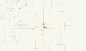
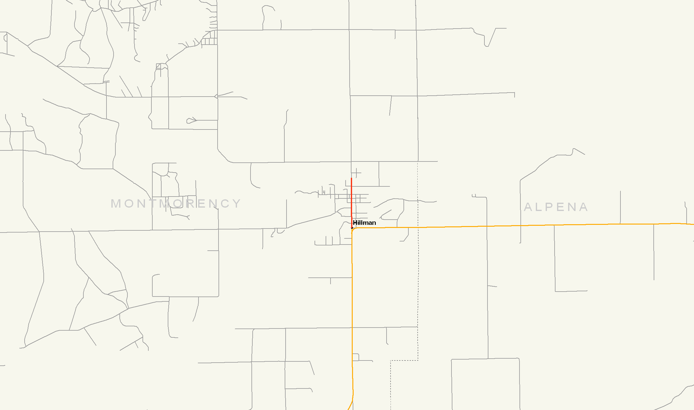
Atlanta 61.72 M-33 north – OnawayWestern end of M-33 concurrency Avery Township 67.67 M-33 south – MioEastern end of M-33 concurrency Hillman  F-21 north (Veterans Memorial Highway)
To BUS M-32; also the former routing of M-32 Alpena Green Township 84.36 M-65 south – CurranWestern end of M-65 concurrency 85.97 M-65 north – Rogers CityEastern end of M-65 concurrency Alpena 100.14 US 23 – Cheboygan, Standish1.000 mi = 1.609 km; 1.000 km = 0.621 mi
Concurrency terminus • Closed/Former • Incomplete access • UnopenedBusiness spur

BUS M-32
Location: Hillman Length: 0.738 mi[2] (1.188 km) Existed: by 1927[13]–present BUS M-32 is a .738-mile (1.188 km)[2] business spur route running through Hillman, Michigan. There are markers present, but BUS M-32 does not connect to M-32. It is the shortest business route in the state, and the second shortest overall trunkline. It is 0.006 miles (0.010 km) longer than M-212 in Aloha. The termini for BUS M-32 are Hillman Road and Old M-32 south of Hillman and the northern city limit along Hillman Road.[2]
 BUS M-32 highlighted in red
References
- ^ a b Michigan State Highway Department (1919). State of Michigan: Lower Peninsula (Map). Cartography by MSHD. http://maps.lib.msu.edu/miroadmaps/1919-lp.htm. Retrieved March 2, 2008.
- ^ a b c d e "Control Section/Physical Reference Atlas". Michigan Department of Transportation. 2001. http://mdotwas1.mdot.state.mi.us/public/maps/pr/. Retrieved January 25, 2008.
- ^ a b "MiGDL - Center for Geographic Information - Geographic Data Library". Michigan Department of Information Technology. May 2007. http://www.mcgi.state.mi.us/mgdl/?rel=thext&action=thmname&cid=14&cat=MI+Geographic+Framework+All+Roads+%28v7b%29. Retrieved February 4, 2008.
- ^ a b Google, Inc. Google Maps – M-32/Water St to E. Washington Ave (Map). Cartography by Google, Inc. http://maps.google.com/maps?f=d&source=s_d&saddr=MI-32%2FWater+St&daddr=M+32%2FMI-32+to:M+32+E%2FMI-32+to:E+Washington+Ave&hl=en&geocode=FUj_sAIdJt7s-g%3BFT6crwIdZDfx-g%3BFeVwrgId9F_2-g%3BFSyVrwIdJuwG-w&mra=ls&via=1,2&sll=45.069278,-83.449144&sspn=0.038674,0.058022&ie=UTF8&t=p&z=9. Retrieved March 26, 2009.
- ^ "The National Highway System". Federal Highway Administration. http://www.fhwa.dot.gov/planning/nhs/. Retrieved April 18, 2009.
- ^ a b "National Highway System: Michigan" (PDF). Federal Highway Administration. August 2006. Archived from the original on December 9, 2006. http://web.archive.org/web/20061209124453/http://www.fhwa.dot.gov/hep10/nhs/maps/mi/mi_michigan.pdf. Retrieved February 8, 2008.
- ^ Michigan State Highway Department (September 1, 1933). 1933 Official Michigan Highway Map (Map). Cartography by Rand McNally.
- ^ Michigan State Highway Department (December 1, 1939). 1939 Official Michigan Highway Map (Map). Cartography by Rand McNally (Winter ed.).
- ^ Michigan State Highway Department (1964). Official Highway Map (Map).
- ^ Michigan Department of State Highways and Transportation (1975). Official Transportation Map (Map). 1 in.:14.5 mi./1 in.:23 km..
- ^ Michigan Department of Transportation (1995). Michigan Department of Transportation Map (Map). 1 in.:14.5 mi./1 cm.:9 km..
- ^ Matheny, Keith (September 18, 2005). "M-32 road extension sought". Traverse City (Michigan) Record -Eagle. http://archives.record-eagle.com/2005/sep/18m32.htm. Retrieved February 8, 2008.
- ^ Michigan State Highway Department (December 1, 1927). Official Highway Service Map (Map). Cartography by MSHD.
External links
Categories:- State highways in Michigan
- Northern Michigan

Wikimedia Foundation. 2010.