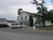
- M-209 (Michigan highway)
-
M-209 Glen Haven Road Route information Maintained by MDOT Length: 0.543 mi[2] (0.874 km) Existed: 1920s[1] – June 5, 1996[2] Major junctions South end:  M-109 near Glen Haven
North end: Coast Guard Life Saving Station in Glen Haven Location Counties: Leelanau Highway system Michigan State Trunkline Highway System
Interstate • US • State←  M-208
M-208M-210  →
→M-209 was a state trunkline route in the lower peninsula of the US state of Michigan. It was located in Leelanau County in the Sleeping Bear Dunes National Lakeshore. Until it was decommissioned, it was Michigan's shortest state highway. M-209 started at M-109 and went 0.543 miles (0.874 km) or just 956 yards (874 m) to Glen Haven. In 1996, M-209's designation was "abandoned", and the road was turned over to the jurisdiction of the Leelanau County Road Commission.[2]
Contents
Route description
M-209 was the short connector route from M-109 to the Glen Haven unit of the Sleeping Bear Dunes National Lakeshore west of Glen Arbor.[3] The southern terminus of the highway was at the intersection with M-109 south of Glen Haven, a restored logging village on the shore of Lake Michigan on the Leelanau Peninsula. The roadway ran north from this intersection where M-109 made a 90–degree corner through the south and east legs of a four-way intersection with M-209 and Dune Valley Road. M-209 ran past such attractions as the restored General Store and Blacksmith Shop. Also located in Glen Haven is the former Glen Haven Canning Co. building. This building was first used as a warehouse and later as a cannery for cherries in the 1920s. It has since been restored as the Cannery Boathouse housing historic wooden boats used in the Manitou Passage between Glen Haven, Glen Arbor and the Manitou Islands.[4] The northern terminus of M-209 was located in front of the former U.S. Coast Guard Life Saving Station, now restored as a maritime museum.[5] The museum is located at the intersection of Glen Haven Road and Sleeping Bear Dunes Road. At the time of decommissioning, M-209 was a two-lane, paved road.
Sleeping Bear Dunes National Lakeshore is a United States National Lakeshore located on the "little finger" of the lower peninsula of Michigan in Leelanau and Benzie counties. The park covers a 35-mile (56 km) stretch of Lake Michigan's eastern coastline, as well as North and South Manitou Islands. The park was authorized on October 21, 1970.
History
From its inception in the 1920s, M-209 was Michigan's shortest highway.[1] It connected the small community of Glen Haven to M-109 just south of the community. Glen Haven was founded as a settlement called Sleeping Bearville with a sawmill and an inn in 1857. By 1881, there were 11 buildings in the community. The lifesaving station was built in 1901 and moved to its present location in 1931 before closing in 1941.[6] M-209 was first assumed as a state trunkline in the 1920s. It would later serve the national lakeshore when the park was created on October 21, 1970. The Park Service purchased all of the village by the mid-1970s. The highway was turned over to Leelanau County control on June 5, 1996.[2] It is now known only as Glen Haven Road.[7] Since the transfer, M-212 in Cheboygan County is now the shortest highway in the state.[8]
Major intersections
The entire highway was in Glen Arbor Township, Leelanau County.
Mile[2] Destinations Notes 0.000  M-109
M-1090.543 Coast Guard station access road 1.000 mi = 1.609 km; 1.000 km = 0.621 mi See also
References
- ^ a b Baird, Thomas (January 31, 2006). "Early modern highways in Leelanau". Leelanau Post. http://www.leelanaupost.com/leelanau_history/. Retrieved February 15, 2008.
- ^ a b c d e "State Administrative Board Resolutions" (PDF). State of Michigan. 1940-Present. http://www.michigan.gov/documents/resolution_list_155716_7.pdf. Retrieved February 13, 2008.
- ^ Michigan Department of Transportation (1995). Michigan Department of Transportation Map (Map). 1 in:14.5 mi/1 cm:9 km. Section G8.
- ^ "Sleeping Bear Dunes National Lakeshore". National Park Service. http://www.nps.gov/slbe/index.htm. Retrieved February 15, 2008.
- ^ "Sleeping Bear Dunes National Lakeshore - Maritime Museum". National Park Service. http://www.nps.gov/slbe/planyourvisit/maritimemusem.htm. Retrieved February 15, 2008.
- ^ Weeks, George. Sleeping Bear: Yesterday and Today. Ann Arbor, Michigan: University of Michigan Press. p. 208. ISBN 0472030310.
- ^ Google, Inc. Google Maps – Glen Haven, MI (Map). Cartography by Google, Inc. http://maps.google.com/maps?f=q&hl=en&geocode=&q=Glen+Haven,+MI&ie=UTF8&ll=44.90583,-86.03062&spn=0.019149,0.030212&z=15. Retrieved February 15, 2008.
- ^ Michigan Department of Transportation (2009). Control Section/Physical Reference Atlas (Map). http://mdotwas1.mdot.state.mi.us/public/maps/pr/. Retrieved July 26, 2009.
External links
Categories:- Former state highways in Michigan
- Transportation in Leelanau County, Michigan
Wikimedia Foundation. 2010.


