- M-44 (Michigan highway)
-
This article is about the state highway in Michigan; for other uses, see M44 (disambiguation)
M-44
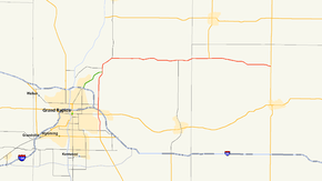
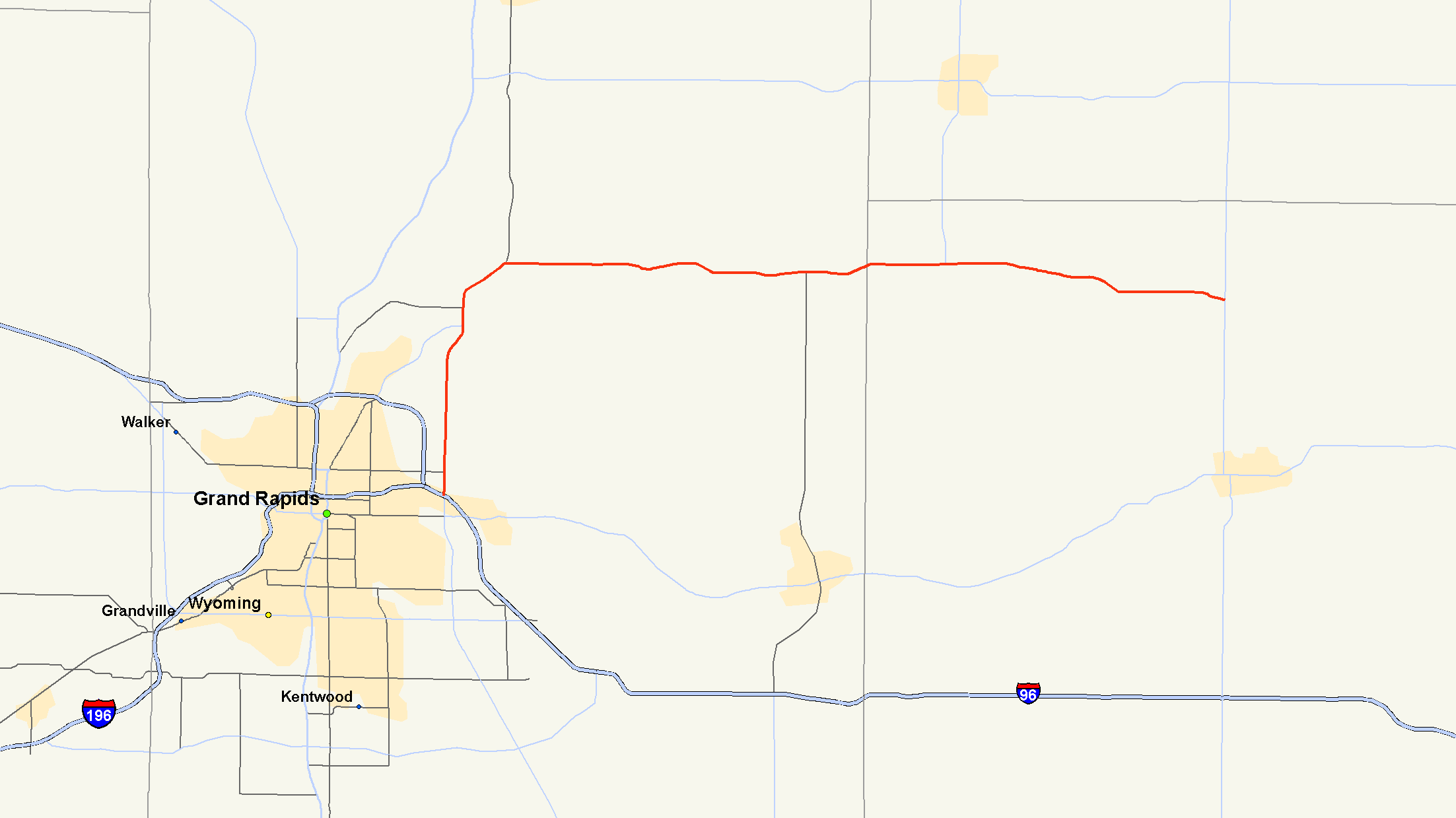
M-44 highlighted in redRoute information Maintained by MDOT Length: 37.463 mi[2] (60.291 km) Existed: c. July 1, 1919[1] – present Major junctions West end:  M-11 in Kentwood
 M-21 near East Grand Rapids
 I-96 in Grand Rapids
East end:  M-66 near Ionia
Location Counties: Kent, Ionia Highway system Michigan State Trunkline Highway System
Interstate • US • State←  M-43
M-43US 45  →
→M-44 is a 37.463-mile (60.291 km) state trunkline highway in the western region of the US state of Michigan. It runs northward from the intersection of M-11 (28th Street) and M-37 toward the Rockford area. The highway then turns eastward to Belding, and it ends six miles (10 km) north of Ionia at M-66. M-44 is known in Grand Rapids as the "East Beltline" and intersects with its related highway, Connector M-44, in Plainfield Township. This highway runs concurrently with M-37 between M-11 and Interstate 96 (I-96).
As a state highway, M-44 dates back to around July 1, 1919, and it was routed along a section of its modern route at that time. The eastern end was altered in the late 1920s, and the western end was extended to the Grand Rapids area in the 1970s. For over 20 years, M-44 was truncated to remove the M-37 concurrency. Since 2003 though, the highway has terminated at the intersection with 28th Street.
Contents
Route description
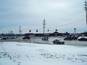 Western terminus of M-44 at the corner of 28th Street and East Beltline Avenue
M-44 starts at the intersection of 28th Street and East Beltline Avenue in Kentwood. M-11 runs east and west along 28th Street and M-37 runs south along Broadmoor Avenue as the continuation of East Beltline. M-44 and M-37 run together on East Beltline Avenue north from this intersection, which is also the location of the Woodland Mall in Kentwood. From here north, M-37/M-44 runs along a four-lane divided boulevard through the campus of Calvin College. East Beltline passes through suburban residential areas near the east end of Reeds Lake and M-21's western terminus at Fulton Street. Just north of this intersection is an interchange with I-96 at exit 38. M-37 leaves the roadway to run along I-96 while M-44 continues northward along East Beltline Avenue.[3][4] All of M-44 to this point is listed on the National Highway System,[5] a network of roadways important to the nation's economy, defense, and mobility.[6]
North of the interchange, M-44 passes the Frederik Meijer Gardens and Sculpture Park and the campus of Cornerstone University. The area around the highway is mixed businesses and office parks north to Knapp Street, and then residential north of there. At Plainfield Avenue, M-44 meets CONN M-44 and crosses the Grand River. M-44 turns eastward near the south side of Rockford and runs through suburban residential areas near Lake Bella Vista, Silver and Bostwick lakes. East of here, the environs transition to rural farmland and the highway crosses the Kent–Ionia county line between Grattan and Cooks Corners, where it meets M-91 west of Belding. The highway continues east through town, where it crosses the Flat River, and ends at M-66 north of Ionia.[3][4]
History
M-44 was first designated by July 1, 1919 beginning at M-13 (later US 131) from Rockford to Belding. Near Orleans, M-44 turned south into town and ended at M-21 in Ionia.[1] The segment near Orleans was realigned to end at M-14 (now M-66) in Woods Corners in 1929.[7][8] M-44 was extended concurrently along US 131 to end at the intersection of the East Beltline and 28th Street near Grand Rapids. Two other highways were also routed on the East Beltline: M-21 south of Fulton Street and M-37 south of Cascade Road.[9][10] The US 131, M-21 and M-37 concurrencies only lasted until 1964 when M-21 was moved to I-196 and M-37 was shifted to the new US 131 freeway.[11][12]
US 131 was moved to its freeway north of Grand Rapids in 1969. The Northland Drive segment of US 131/M-44 was redesignated as only M-44, and the Plainfield Avenue segment became CONN M-44. M-37 was rerouted as well up East Beltline from M-11 concurrently with M-44 to I-96.[13][14] In 1977, this junction at I-96 became the official western terminus of M-44, with the M-44 signs along East Beltline Avenue removed.[15][16] Then in 2003, the signs along the East Beltline were restored and the route extended back to its former terminus.[17][18]
Major intersections
County Location Mile[2] Destinations Notes Kent Kentwood 0.000  M-11 (28th Street) / M-37 south (East Beltline Avenue)
M-44 runs concurrently with M-37 north along East Beltline Avenue Grand Rapids Township 3.522 M-21 (Fulton Street) – LowellWestern terminus of M-21 Grand Rapids 4.209–
4.231 I-96 / M-37 north – Muskegon, LansingM-37 concurrency ends at exit 38 on I-96 Plainfield Township 10.065 
 CONN M-44
Northern terminus of CONN M-44 12.873 Northland Drive – Rockford Old US 131 Ionia Otisco Township 27.855  M-91 north – Greenville
Southern terminus of M-91 Orleans Township –
Ronald Township37.463 M-66 – Ionia, Stanton1.000 mi = 1.609 km; 1.000 km = 0.621 mi
Concurrency terminus • Closed/Former • Incomplete access • UnopenedConnector route

CONN M-44
Location: Kent County Length: 4.185 mi[2] (6.735 km) Existed: 1969[13][14]–present M-44 Connector, or CONN M-44, is a 4.185-mile (6.735 km) connector route state trunkline highway running along Plainfield Avenue in the Grand Rapids area.[2] It connects I-96/M-37 near Lamberton Lake with M-44 running along East Beltline Avenue near the Grand River. In between, the highway passes through a commercial area. North of 5 Mile Road, Plainfield Avenue takes on a more suburban residential character. There are more business again at the northern end by Versluis Lake.[19] CONN M-44 was formed in 1969 when the US 131 freeway was completed from I-96/M-37 to 14 Mile Road near Rockford. US 131 along Plainfield Avenue was redesignated as CONN M-44 to connect I-96/M-37 with M-44.[13][14]
References
- ^ a b Michigan State Highway Department (July 1, 1919). State of Michigan: Lower Peninsula (Map). Cartography by MSHD.
- ^ a b c d "MDOT Physical Reference Finder Application". Michigan Department of Transportation. 2009. http://www.mcgi.state.mi.us/prfinder/. Retrieved February 11, 2011.
- ^ a b Michigan Department of Transportation (2010). Official Department of Transportation Map (Map). 1 in:15 mi/1 cm:9 km. Section K9–K10.
- ^ a b Google, Inc. Google Maps – Overview Map of M-44 (Map). Cartography by Google, Inc. http://maps.google.com/maps?f=d&source=s_d&saddr=E+Beltline+Ave+SE&daddr=M-44+E%2FBelding+Rd&hl=en&geocode=FbTLjgIdtBnm-g%3BFaM8kQId89Dt-g&mra=dme&mrcr=0&mrsp=1&sz=12&sll=43.1075,-85.13958&sspn=0.236113,0.232773&ie=UTF8&ll=43.009668,-85.323944&spn=0.945958,0.931091&t=h&z=10. Retrieved February 11, 2011.
- ^ Michigan Department of Transportation (2005). National Highway System: Grand Rapids Urbanized Area (Map). http://www.michigan.gov/documents/MDOT_NHS_Grand_Rapids_150613_7.pdf. Retrieved February 11, 2011.
- ^ "The National Highway System". Federal Highway Administration. August 26, 2010. http://www.fhwa.dot.gov/planning/nhs/. Retrieved January 1, 2011.
- ^ Michigan State Highway Department (May 1, 1929). Official Highway Service Map (Map). Cartography by MSHD.
- ^ Michigan State Highway Department (January 1, 1930). Official Highway Service Map (Map). Cartography by H.M. Gousha.
- ^ Michigan State Highway Department (1961). Official Highway Map (Map). Grand Rapids inset. (Includes all changes through July 1, 1961)
- ^ Michigan State Highway Department (1962). Official Highway Map (Map). Grand Rapids inset.
- ^ Michigan State Highway Department (1964). Official Highway Map (Map). Grand Rapids inset.
- ^ Michigan State Highway Department (1965). Official Highway Map (Map). Grand Rapids inset.
- ^ a b c Michigan Department of State Highways (1969). Official Highway Map (Map). Cartography by H.M. Gousha. Grand Rapids inset.
- ^ a b c Michigan Department of State Highways (1970). Official Highway Map (Map). Grand Rapids inset.
- ^ Michigan Department of State Highways and Transportation (1977). Official Transportation Map (Map). Grand Rapids inset.
- ^ Michigan Department of State Highways and Transportation (1978). Official Transportation Map (Map) (1978–79 ed.). Grand Rapids inset.
- ^ Michigan Department of Transportation (2003). Official Department of Transportation Map (Map). 1 in:3 mi/1 cm:2 km (2003–04 ed.). Grand Rapids inset.
- ^ Michigan Department of Transportation (2004). Official Department of Transportation Map (Map). 1 in:3 mi/1 cm:2 km (2003–04 ed.). Grand Rapids inset.
- ^ Google, Inc. Google Maps – Oveview Map of CONN M-44 (Map). Cartography by Google, Inc. http://maps.google.com/maps?f=d&source=s_d&saddr=Michigan+44+Connector%2FPlainfield+Ave+NE&daddr=Michigan+44+Connector%2FPlainfield+Ave+NE&hl=en&geocode=FTRwkAIdplHl-g%3BFXT4kAIdEB7m-g&mra=dme&mrcr=0&mrsp=0&sz=12&sll=43.03974,-85.61924&sspn=0.236374,0.232773&ie=UTF8&ll=43.042422,-85.603065&spn=0.118182,0.116386&t=h&z=13. Retrieved February 11, 2011.
External links
Categories:- State highways in Michigan


Wikimedia Foundation. 2010.