- M-109 (Michigan highway)
-
M-109 
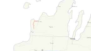
M-109 highlighted in redRoute information Maintained by MDOT Length: 6.831 mi[2] (10.993 km) Existed: ca. May 1, 1929[1] – present Major junctions South end:  M-22 near Empire
North end:  M-22 at Glen Arbor
Location Counties: Leelanau Highway system Michigan State Trunkline Highway System
Interstate • US • State←  M-108
M-108M-110  →
→M-109 is the designation of a state trunkline highway in the Lower Peninsula of the US state of Michigan that runs between Empire and Glen Arbor. M-109 is a loop connected to M-22 at both ends that allows tourists access to Sleeping Bear Dunes National Lakeshore and the Pierce Stocking Scenic Drive located on a section of sandy land between Lake Michigan and Glen Lake.
Contents
Route description
M-109 starts on M-22 north of Empire. It loops north towards Glen Haven, a former logging town on the shores of Lake Michigan, following Dunes Highway. Near the southern terminus is the Maple Grove Cemetery. Head north, M-109 provides access to the Pierce Stocking Scenic Drive and the Dune Climb before reaching Glen Haven Road. Glen Haven Road continues north from a turn in M-109. Glen Haven Road is the route of the former M-209. From there M-109 heads east to the community of Glen Arbor. On the east–west segment, M-109 passes the D.H. Day Campground and ends at M-22 in Glen Arbor.
Sleeping Bear Dunes National Lakeshore
Main article: Sleeping Bear Dunes National LakeshoreSleeping Bear Dunes National Lakeshore is a United States National Lakeshore located on the "little finger" of the lower peninsula of Michigan in Leelanau County and Benzie County.
The park covers a 35 mile (60 km) area of Lake Michigan's eastern coastline, as well as North and South Manitou Islands. The park was established primarily for its outstanding natural features, including forests, beaches, dune formations, and ancient glacial phenomena. The Lakeshore also contains many cultural features including the 1871 South Manitou Island Lighthouse, three former Life-Saving Service/Coast Guard Stations and an extensive rural historic farm district. The park was authorized on October 21, 1970.
History
The first section of roadway to receive the M-109 designation was in place and signed on maps by May 1, 1929. The roadway was a spur from M-22 north of Empire that ended at Glen Haven, just west of the D.H. Day State Park.[1] The highway was extended east along an existing road between Glen Haven and Glen Arbor. This extension was in place by May 1, 1933, completing the modern routing of M-109.[3]
Major intersections
The entire highway is in Leelanau County.
Location Mile[2] Destinations Notes Empire Township 0.000 
 M-22 / LMCT – Empire
Glen Haven Glen Haven Road Former M-209 Glen Arbor 6.831 
 M-22 / LMCT – Leland
1.000 mi = 1.609 km; 1.000 km = 0.621 mi References
- ^ a b Michigan State Highway Department (May 1, 1929). Official Highway Service Map (Map). Cartography by MSHD.
- ^ a b Michigan Department of Transportation (2009). Control Section/Physical Reference Atlas (Map). http://mdotwas1.mdot.state.mi.us/public/maps/pr/. Retrieved July 2, 2009.
- ^ Michigan State Highway Department (May 1, 1933). Official Highway Service Map (Map). Cartography by MSHD.
External links
Categories:- State highways in Michigan
Wikimedia Foundation. 2010.


