- M-22 (Michigan highway)
-
This article is about the state highway in Michigan; for other uses, see M22 (disambiguation)
M-22
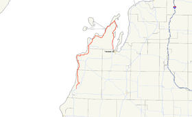
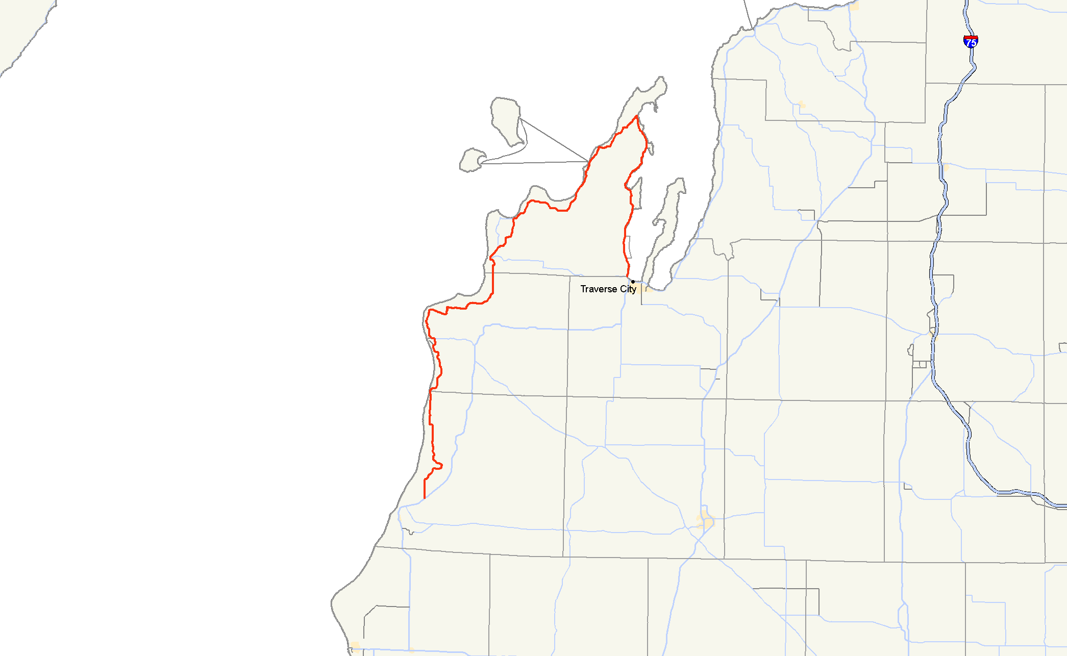
M-22 highlighted in redRoute information Maintained by MDOT Length: 116.651 mi[2] (187.732 km) Existed: ca. July 1, 1919[1] – present Tourist
routes:Lake Michigan Circle Tour, Leelanau Scenic Heritage Route Major junctions South end:  US 31 near Manistee
 M-115 at Frankfort
 M-72 at Empire
 M-204 near Lake Leelanau
 M-201 at Northport
M-204 at Suttons Bay M-72 in GreilickvilleNorth end:  US 31 / M-37 / M-72 in Traverse City
Location Counties: Manistee, Benzie, Leelanau, Grand Traverse Highway system Michigan State Trunkline Highway System
Interstate • US • State←  M-21A
M-21AUS 23  →
→M-22 is a state trunkline highway in the US state of Michigan. It is 116.651 miles (187.732 km) long and follows the Lake Michigan shoreline of the Leelanau Peninsula, making up a portion of the Lake Michigan Circle Tour. It also passes through the Sleeping Bear Dunes National Lakeshore. The highway is U-shaped as it rounds the peninsula running through tourist areas in Leland and Suttons Bay in addition to the national park.
M-22 is an original trunkline designation dating back to the 1919 designation of the system. Reroutings have moved the highway closer to the water between Suttons Bay and Traverse City. A section of the highway used temporarily even was used for another highway, M-109. The highway was also named a Michigan Heritage Route. The route marker shield is used in marketing by a local business as a symbol of the region.
Contents
Route description
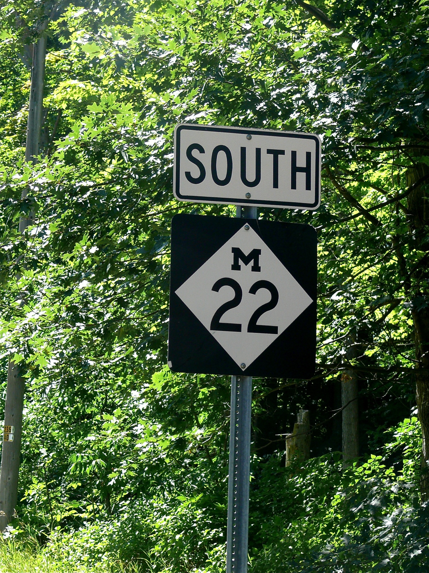
 Marker at Good Harbor, south of Leland
The southern terminus is 3 miles (5 km) northeast of Manistee and the northern terminus is in Traverse City. In between the trunkline loops north along Lake Michigan to Northport before turning south along the West Arm of Grand Traverse Bay. The road itself comprises numerous turns and hills, making it a very popular drive for tourists visiting the area from areas such as Chicago and Detroit, especially during autumn. The road runs north to the village of Onekama running east and north of Portage Lake before returning north to Arcadia. M-22 turns northeasterly to curve around the north shore of Crystal Lake after passing through Elberta and Frankfort. South of the Platte River, the highway crosses into the Sleeping Bear Dunes National Lakeshore. East of Platte Lake, M-22 turns northward again toward Empire, headquarters of the national park. M-22 takes the inland route between Little and Big Glen lakes, losing the Lake Michigan Circle Tour designation to M-109 until the two meet again in Glen Arbor. The roadway follows the shoreline of Pyramid Point and passes east out of the national park before turning north to Leland.[3]
Leland is home to Fishtown, and the ferries to the Manitou Islands off the coast of the Leelanau Peninsula. Continuing northward, M-22 reaches its northernmost extent in Northport before turning south. It passes through the reservation of the Grand Traverse Band of Chippewa and Ottawa Indians in Peshawbestown, home to one of the tribe's two casinos. Further south is the community of Suttons Bay located on the small bay of the same name. From here south, the highway runs just off the shore of the Grand Traverse Bay south to Greilickville. Just south of Greilickville, M-22 enters a section of the city of Traverse City that's located in Leelanau County, Michigan formed by an acquisition of a neighborhood of Greilickville. Here is the eastern junction between M-22 and M-72. The two highways run concurrently along Grandview Parkway to Division Street. There they meet US 31/M-37 and M-22 ends.[3] A portion of this road has been designated a scenic heritage route by the state of Michigan.[4]
History
M-22 is an original trunkline, dating to the 1919 signing of the system.[1] In 1929, the highway was rerouted along the west side of Big Glen Lake, using the modern M-109 around the lake.[5] M-22 would be rerouted back around to the present routing and M-109 formed on the west side of the lake.[6]
Until 1936, M-22's route was on Cherry Bend and Center Rds. in Leelanau County to Suttons Bay. At that time, M-22 was relocated along the west arm of Grand Traverse Bay onto Center Rd. up to Crain Hill Rd.[7][8] In 1949, M-22 was relocated the rest of the way to Suttons Bay, and the former M-22 on Cherry Bend and Center Rds. became County Rd. 633.[9][10] and in 1945, the last gravel stretch of M-22 from Leland to Northport was paved.[11]
In Traverse City, M-22 originally started at Front and Union Sts. going west on Front to Elmwood, turning north onto Elmwood, then west on Bay St. to Greilickville. It was relocated onto the newly built Grand View Parkway in 1952, from Greilickville to Division St. (relocated US 31).[12]
Cultural references
Broneah Kiteboarding, a company based in Traverse City, has adopted the M-22 shield as a logo, and sells merchandise such as hooded sweatshirts, T-shirts, and bumper stickers featuring the shield. As such, it has become a popular symbol for the company as well as a cultural symbol for the western Grand Traverse Bay area.[13]
Major intersections
County Location Mile[2][14] Destinations Notes Manistee Manistee Township 0.00  US 31 south / LMCT – Manistee, Traverse City
Southern end of LMCT concurrency Benzie Elberta 27.793  M-168 west
Eastern terminus of M-168 Frankfort 20.006 M-115 eastWestern terminus of M-115 Leelanau Empire 51.849 M-72 east – Traverse CityWestern terminus of M-72 Empire Township 53.911  M-109 north – Glen Haven
Southern terminus of M-109 Glen Arbor 59.576 M-109 west – Glen HavenEastern terminus of M-109 Leland Township 76.021 M-204 east – Lake LeelanauWestern terminus of M-204 Northport 89.283 M-201 northSouthern terminus of M-201 Suttons Bay 100.765 M-204 west – Lake LeelanauEastern terminus of M-204 Traverse City 116.071 M-72 west – EmpireNorthern end of M-72 concurrency Grand Traverse 116.651 US 31 / M-37 / M-72 east / LMCT northSouthern end of M-72 concurrency; northern end of LMCT concurrency 1.000 mi = 1.609 km; 1.000 km = 0.621 mi
Concurrency terminus • Closed/Former • Incomplete access • UnopenedReferences
- ^ a b Michigan State Highway Department (1919). State of Michigan (Map). Cartography by MSHD. http://maps.lib.msu.edu/miroadmaps/mirm5.htm. Retrieved March 2, 2008.
- ^ a b Michigan Department of Transportation (2009). Control Section/Physical Reference Atlas (Map). http://mdotwas1.mdot.state.mi.us/public/maps/pr/. Retrieved July 26, 2009.
- ^ a b Michigan Department of Transportation (2008). Official 2008 Department of Transportation Map (Map). 1 in:15 mi/1 cm:9 km. http://www.michigan.gov/mdot/0,1607,7-151-9622_11033_11151---,00.html.
- ^ "Scenic Heritage Routes". Michigan Heritage Routes. Michigan Department of Transportation. November 8, 2007. http://www.michigan.gov/mdot/0,1607,7-151-9621_11041_11209-22895--,00.html. Retrieved September 11, 2008.
- ^ Michigan State Highway Department (1929). Official Highway Service Map (Map). Cartography by H.M. Gousha.
- ^ Michigan State Highway Department (January 1, 1930). Official Highway Service Map (Map). Cartography by H.M. Gousha.
- ^ Michigan State Highway Department (June 1, 1936). Official Highway Map (Map). Cartography by Rand McNally.
- ^ Michigan State Highway Department (1936/7). Official Highway Map (Map). Cartography by Rand McNally (Winter ed.).
- ^ Michigan State Highway Department (July 1, 1949). Official Highway Map (Map).
- ^ Michigan State Highway Department (April 15, 1950). Official Highway Map (Map).
- ^ Michigan State Highway Department (October 1, 1945). Official Highway Map (Map).
- ^ Michigan State Highway Department (April 1, 1952). Official Highway Map (Map).
- ^ "M-22 Clothing and Accessories". Broneah Kiteboarding. 2008. http://www.m22online.com/#. Retrieved September 11, 2008.
- ^ "MDOT Physical Reference Finder Application". Michigan Department of Transportation. 2009. http://www.mcgi.state.mi.us/prfinder/. Retrieved April 9, 2010.
External links
Categories:- State highways in Michigan
- Lake Michigan Circle Tour

Wikimedia Foundation. 2010.