- Manistee County, Michigan
-
Manistee County, Michigan 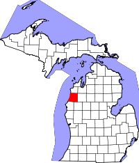
Location in the state of Michigan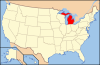
Michigan's location in the U.S.Founded information needed Seat Manistee Area
- Total
- Land
- Water
1,280.77 sq mi (3,317 km²)
543.61 sq mi (1,408 km²)
737.16 sq mi (1,909 km²), 57.56%Population
- (2010)
- Density
24,733
44/sq mi (17/km²)Website www.manisteecounty.net Manistee County is a county in the U.S. state of Michigan. As of the 2010 census, the population was 24,733.[1] The county seat is Manistee[2]. The name "Manistee" is from an Ojibwe word first applied to the principal river of the county.[3] The derivation is not certain,[4] but it may be from ministigweyaa, "river with islands at its mouth".[5][6]
Contents
History
The county was set off in 1840 and organized in 1855.[7]
Historical markers
There are thirteen recognized Michigan historical markers in the county:[8]
- Harriet Quimby / Childhood Home
- John J. Makinen Bottle House
- First Congregational Church, Manistee
- Great Fire of 1871
- Holy Trinity Episcopal Church
- Holy Trinity Episcopal Church Rectory
- Kaleva, Michigan
- Manistee City Library
- Manistee Fire Hall
- Our Saviour's Lutheran Church
- Ramsdell Theatre
- Trinity Lutheran Church [Arcadia]
- William Douglas House
Government
The county government operates the jail, maintains rural roads, operates the major local courts, keeps files of deeds and mortgages, maintains vital records, administers public health regulations, and participates with the state in the provision of welfare and other social services. The county board of commissioners controls the budget but has only limited authority to make laws or ordinances. In Michigan, most local government functions — police and fire, building and zoning, tax assessment, street maintenance, etc. — are the responsibility of individual cities and townships.
Manistee County elected officials
- Prosecuting Attorney: Ford Stone
- Sheriff: Dale Kowalkowski
- County Clerk: Marilyn Kliber
- County Treasurer: Russell Pomeroy
- Register of Deeds: Penny Pepera
- Drain Commissioner: Kenneth R. Berentsen
- County Surveyor: Anthony Slawinski
(information as of September 2005)
Geography
- According to the 2000 census, the county has a total area of 1,280.77 square miles (3,317.2 km2), of which 543.61 square miles (1,407.9 km2) (or 42.44%) is land and 737.16 square miles (1,909.2 km2) (or 57.56%) is water.[9]
- Manistee County-Blacker Airport is approximately three miles (4.8 km) northeast of Manistee.
- Manistee is considered to be part of Northern Michigan.
Highways
 US 31
US 31 M-22
M-22 M-55 starts two miles north of Manistee, and proceeds 155 miles across the Lower Peninsula to Tawas.[10]
 M-115
M-115
Cities, villages, and townships
Cities
Unincorporated
- Arcadia
- Brethren
- Chief
- Marilla
- Norwalk
- Pierport
- Parkdale
- Wellston
Townships
Adjacent counties
- Benzie County - north
- Grand Traverse County - northeast
- Wexford County - east
- Lake County - southeast
- Mason County - south
- Manitowoc County, Wisconsin - southwest
- Kewaunee County, Wisconsin - west

Benzie County Grand Traverse County Kewaunee County, Wisconsin 
Wexford County  Manistee County, Michigan

Manitowoc County, Wisconsin Mason County Lake County National protected area
- Manistee National Forest (part)
Demographics
As of the census[11] of 2000, there were 24,527 people, 9,860 households, and 6,714 families residing in the county. The population density was 45 people per square mile (17/km²). There were 14,272 housing units at an average density of 26 per square mile (10/km²). The racial makeup of the county was 94.16% White, 1.63% Black or African American, 1.30% Native American, 0.32% Asian, 0.03% Pacific Islander, 1.01% from other races, and 1.55% from two or more races. 2.61% of the population were Hispanic or Latino of any race. 23.5% were of German, 16.9% Polish, 8.8% English, 8.8% American and 7.1% Irish ancestry according to Census 2000. 96.2% spoke English and 2.3% Spanish as their first language.
There were 9,860 households out of which 27.40% had children under the age of 18 living with them, 55.10% were married couples living together, 9.10% had a female householder with no husband present, and 31.90% were non-families. 27.30% of all households were made up of individuals and 13.20% had someone living alone who was 65 years of age or older. The average household size was 2.37 and the average family size was 2.86.
In the county the population was spread out with 22.60% under the age of 18, 6.70% from 18 to 24, 26.30% from 25 to 44, 26.30% from 45 to 64, and 18.10% who were 65 years of age or older. The median age was 42 years. For every 100 females there were 103.40 males. For every 100 females age 18 and over, there were 102.00 males.
The median income for a household in the county was $34,208, and the median income for a family was $41,664. Males had a median income of $33,211 versus $20,851 for females. The per capita income for the county was $17,204. About 6.90% of families and 10.30% of the population were below the poverty line, including 13.50% of those under age 18 and 7.90% of those age 65 or over.
See also
Notes
- ^ "American FactFinder". United States Census Bureau. http://factfinder2.census.gov/main.html. Retrieved 3 May 2011.
- ^ "Find a County". National Association of Counties. http://www.naco.org/Counties/Pages/FindACounty.aspx. Retrieved 2011-06-07.
- ^ Clarke Historical Library, Central, Michigan University, Bibliography for Manistee County
- ^ Bright, William (2004). Native American Place Names of the United States. Norman: Oklahoma University Press, pg. 265
- ^ County place names
- ^ "Manistee County, Michigan". 50-State Learning Resource Guide. http://www.e-referencedesk.com/resources/counties/michigan/manistee.html. Retrieved 2009-04-07. See also, List of Michigan county name etymologies and Kaministiquia River.
- ^ Ibid.
- ^ Michigan Historical Markers
- ^ "Census 2000 U.S. Gazetteer Files: Counties". United States Census. http://www.census.gov/tiger/tms/gazetteer/county2k.txt. Retrieved 2011-02-13.
- ^ M-55 end point photos
- ^ "American FactFinder". United States Census Bureau. http://factfinder.census.gov. Retrieved 2008-01-31.
Further reading
Municipalities and communities of Manistee County, Michigan City 
Villages Charter
townshipGeneral law
townshipsArcadia | Bear Lake | Brown | Cleon | Dickson | Manistee | Maple Grove | Marilla | Norman | Onekama | Pleasanton | Springdale | Stronach
Unincorporated
communitiesNorthern Michigan Topics Major Highways Central cities Satellite cities Region Outlying regions Counties See also: MichiganCategories:
- Michigan counties
- Manistee County, Michigan
- 1855 establishments in the United States


Wikimedia Foundation. 2010.