- M-115 (Michigan highway)
-
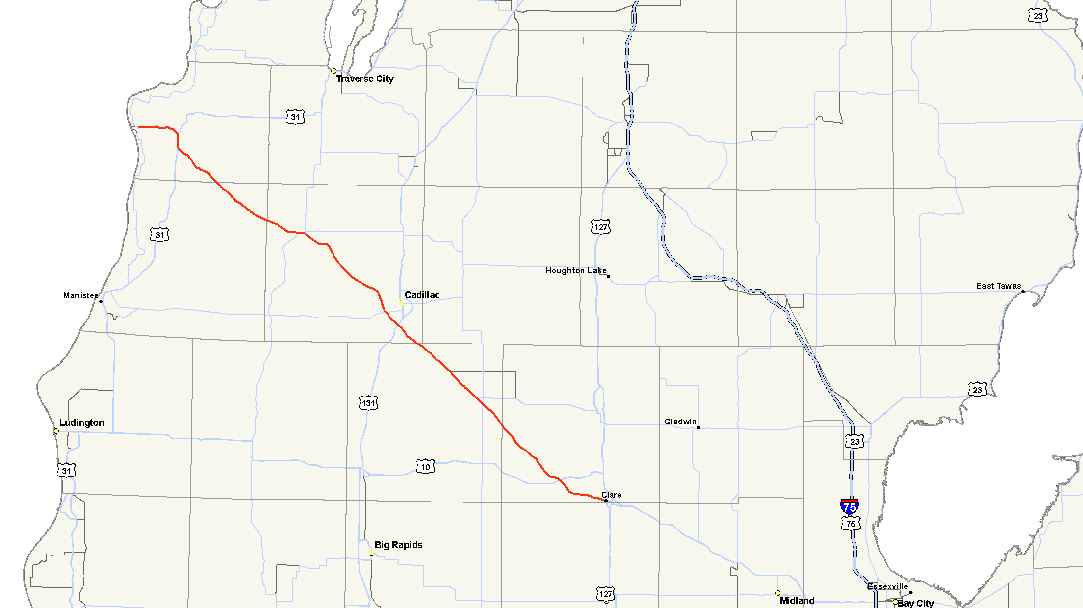
M-115
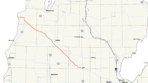
M-115 highlighted in redRoute information Maintained by MDOT Length: 96.432 mi[2] (155.192 km) Existed: c. May 1929[1] – present Major junctions South end: 


 BUS US 127 / BUS US 10 in Clare US 10 near Farwell

 M-66 / M-61 near Temple

 US 131 / M-55 near Cadillac
 M-37 in Mesick
 US 31 near Benzonia
North end:  M-22 in Frankfort
Location Counties: Clare, Osceola, Wexford, Manistee, Benzie Highway system Michigan State Trunkline Highway System
Interstate • US • State←  M-114
M-114M-116  →
→M-115 is a state trunkline highway in the northwestern part of the Lower Peninsula of the US state of Michigan. The highway takes a generally southeast-to-northwest direction between Clare and Frankfort on Lake Michigan. The southeastern end in downtown Clare is at an intersection with Business US Highway 127 (BUS US 127) and BUS US 10; the northwestern end is at M-22 next to Betsie Lake. In between, the trunkline runs 96.432 miles (155.192 km) through woodlands, including areas that are a part of either the Manistee National Forest or the Pere Marquette State Forest. The highway also passes agricultural areas, several lakes in the region and a state park near Cadillac.
M-115 was first designated in the 1920s on the northern end near Frankfort. Additional, disconnected sections were designed as part of the trunkline in the 1930s near Cadillac, Farwell and Mesick. All but one of these gaps (Cadillac–Mesick) was eliminated by the end of that decade. The remaining segment was built in the 1950s to unite M-115 into a single highway. The last change came in 1989 when the highway was extending into Clare to its current southern terminus.
Contents
Route description
M-115 starts in downtown Clare at a four-way intersection with the two business loops, BUS US 127 and BUS US 10, in town. From this junction, M-115 runs west following the former routing of US 10 along Ludington Drive to Farwell. In the middle of town, M-115 turns northwesterly to meet the end of the US 10 freeway near Surrey Lake. The highway continues northwest through forest lands and lake country. The trunkline passes into northern Osceola County near its crossing of the Muskegon River. There are intersections with both M-66 and M-61 south of Marion near rural farms. The roadway subsequently crosses into southern Wexford County. Near Stone Lake south of Cadillac, M-115 meets US 131 and M-55. M-55 leaves the US 131 freeway and joins M-115, and the two run concurrently along the western end of Lake Cadillac. They separate near Lake Mitchell, and M-115 turns northwesterly between the two lakes passing Mitchell State Park and the eastern shore of the latter lake.[3][4]
Past the Cadillac area, M-115 runs through the northeastern corner of the Manistee National Forest.[5] The highway continues through woodlands, passing several small lakes in the area as it approaches the community of Mesick. There it turns due west and joins M-37 through town. The two highways form a wrong way concurrency; M-115 is signed northbound while M-37 is signed southbound and vice versa while physically running east–west. After M-55 separates to the south, M-115 crosses the Manistee River and continues its northwestern course. The highway crosses the northeastern corner of Manistee County and runs through the community of Copemish on the way to Benzonia. The landscape here turns more agricultural as the highway skirts southwest of Thompsonville crossing the Betsie River.[3][4]
After the river crossing, the highway enters Benzie County and runs through the Pere Marquette State Forest. South of Benzonia, M-115 runs concurrently with US 31 into town. The highways separate in the center of town where M-115 turns westward to run along the south shore of Crystal Lake past Frankfort Dow Memorial Field, the local airport near Frankfort. M-115 follows Forest Avenue, and the highway designation ends at the intersection in town with M-22 near Betsie Lake.[3][4]
The Michigan Department of Transportation (MDOT) maintains M-115 like all other trunkline highways in the state under its jurisdiction. As a part of these responsibilities, the department tracks traffic volumes along its roadways until a metric called average annual daily traffic (AADT). This number is a calculation of the traffic level along a segment of roadway for any average day of the year. In 2009, MDOT determined that the highest traffic levels along M-115 were the 12,079 vehicles daily along the section of highway near lakes Mitchell and Cadillac. The lowest AADT was the 2,236 vehicles near Copemich.[6] The trunkline between the US&nbps;10 and M-37 junctions has been listed on the National Highway System.[7] a network of roads important to the country's defense, economy and mobility.[8]
History
In 1929, the first stretch of M-115 was designated from Benzonia to Frankfort.[1] Beginning in the mid 1930s, construction of M-115 began from central to northwestern Lower Michigan. In 1936, an earthen highway was opened between the south side of Cadillac to M-66, with additional sections west of Mesick and northwest of US 10.[9] By the end of the year, the state was paving the earthen section, completed a gravel highway near Mesick and opened an earthen section in Clare County.[10] The section northwest of Mesick to Copemish was opened as an earthen highway the next year.[11] Construction started in early 1938 to connect Benzonia to Copemish,[12] and before the year was out, the Michigan State Highway Department started work to fill in the gap between M-66 and the highway north of US 10 in Clare County.[13] These two sections were completed as earth-graded highway in 1939.[14] Both discontinuous sections were fully paved by 1945.[15]
In 1953, a county road is built along the path of the future M-115 between Mesick and Cadillac.[16][17] This road was designated as a state highway by 1957, with a connection along Boon Road north of Cadillac and a concurrency along US 131 to close the gap in 1957.[18][19] The Boon Road segment was removed the next year when the routing near Lake Mitchell opened.[20] The southern end of M-115 was truncated slightly when the US 10 freeway bypass of Clare was opened in 1975.[21][22] M-115 has since been rerouted in 1989 along the two-lane Old US 10 from Clare through Farwell to its original southeastern starting point near the US 10 overpass and continuing northwesterly.[23][24]
Major intersections
MDOT has inventoried M-115 in a northwest-to-southeast fashion, and signed it as a north–south highway.
County Location Mile[2] Destinations Notes Clare Clare 96.432
BUS US 127 / BUS US 10Surrey Township 89.402 US 10 – Clare, LudingtonFreeway begins on US 10 Osceola Middle Branch Township 71.580 M-66 – Marion, Ionia70.346 M-61 east – HarrisonWestern terminus of M-61 Wexford Clam Lake Township 53.687–
53.706 US 131 / M-55 east – Kalkaska, Grand RapidsExit 176 on US 131; eastern end of M-55 concurrency Cadillac 50.747 M-55 west (Lake Mitchell Drive) – ManisteeWestern end of M-55 concurrency Springville Township 32.962 M-37 north – Traverse CitySouthern end of M-37 concurrency; begin wrong-way concurrency Mesick 31.888 M-37 south – BaldwinNorthern end of M-37 concurrency; end wrong-way concurrency Manistee No major junctions Benzie Joyfield Township 8.777 US 31 south – ManisteeSouthern end of US 31 concurrency Benzonia 6.565 US 31 north – Traverse City, PetoskeyNorthern end of US 31 concurrency Frankfort 0.000  M-22 / LMCT – Manistee, Empire
1.000 mi = 1.609 km; 1.000 km = 0.621 mi
Concurrency terminus • Closed/Former • Incomplete access • UnopenedReferences
- ^ a b Michigan State Highway Department (May 1, 1929). Official Highway Service Map (Map). Cartography by MSHD.
- ^ a b "MDOT Physical Reference Finder Application". Michigan Department of Transportation. 2009. http://www.mcgi.state.mi.us/prfinder/. Retrieved March 9, 2011.
- ^ a b c Michigan Department of Transportation (2010). Official Department of Transportation Map (Map). 1 in:15 mi/1 cm:9 km.
- ^ a b c Google, Inc. Google Maps – Overview Map of M-115 (Map). Cartography by Google, Inc. http://maps.google.com/maps?f=d&source=s_d&saddr=Clare,+MI&daddr=Forest+Ave&hl=en&geocode=Fc6hnAIdjIjy-illD6XgUlEfiDERzKjH84CQMQ%3BFaYNqQIdyFbc-g&mra=ls&sll=43.832546,-84.817543&sspn=0.115782,0.116386&ie=UTF8&t=h&z=9. Retrieved March 10, 2011.
- ^ Rand McNally (2008). The Road Atlas: Michigan (Map). pp. 50-1, section J5–M8. ISBN 0-528-93981-5.
- ^ Bureau of Transportation Planning (2008). "Traffic Monitoring Information System". Michigan Department of Transportation. http://mdotnetpublic.state.mi.us/tmispublic/. Retrieved March 9, 2011.
- ^ Michigan Department of Transportation (April 23, 2006) (PDF). National Highway System, Michigan (Map). http://www.michigan.gov/documents/MDOT_NHS_Statewide_150626_7.pdf. Retrieved October 7, 2008.
- ^ "The National Highway System". Federal Highway Administration. August 26, 2010. http://www.fhwa.dot.gov/planning/nhs/. Retrieved January 1, 2011.
- ^ Michigan State Highway Department (June 1, 1936). 1936 Official Michigan Highway Map (Map). Cartography by Rand McNally. Section H8–H9, I9–I10.
- ^ Michigan State Highway Department (December 15, 1936). 1936/7 Official Michigan Highway Map (Map). Cartography by Rand McNally (Winter ed.). Section H8–H9, I9–I10.
- ^ Michigan State Highway Department (December 1, 1937). 1937/8 Official Michigan Highway Map (Map). Cartography by Rand McNally (Winter ed.).
- ^ Michigan State Highway Department (May 1, 1938). 1938 Official Michigan Highway Map (Map). Cartography by Rand McNally (Spring ed.). Section G8–H8.
- ^ Michigan State Highway Department (December 1, 1938). 1938 Official Michigan Highway Map (Map). Cartography by Rand McNally (Winter ed.). Section I9–I10.
- ^ Michigan State Highway Department (December 1, 1939). 1939 Official Michigan Highway Map (Map). Cartography by Rand McNally (Winter ed.). Section G8–H8, I9–I10.
- ^ Michigan State Highway Department (October 1, 1945). Official Highway Map of Michigan (Map). Section G8–I10.
- ^ Michigan State Highway Department (April 15, 1953). 1953 Official Highway Map (Map). Section H9.
- ^ Michigan State Highway Department (October 1, 1953). 1953 Official Highway Map (Map). Section H9.
- ^ Michigan State Highway Department (October 1, 1956). 1956 Official Highway Map (Map). Section H9.
- ^ Michigan State Highway Department (April 1, 1957). 1957 Official Highway Map (Map). Section H9.
- ^ Michigan State Highway Department (1958). Official Highway Map (Map). Section H9. (Includes all changes through July 1, 1958)
- ^ Michigan Department of State Highways and Transportation (1975). Official Transportation Map (Map). 1 in:14.5 mi/1 in:23 km. Section I10.
- ^ Michigan Department of State Highways and Transportation (1976). Official Transportation Map (Map). 1 in:14.5 mi/1 in:23 km (1976–1977 ed.). Section I10.
- ^ Michigan Department of Transportation (1989). Michigan Department of Transportation Map (Map). 1 in:14.5 mi/1 in:23 km. Section I10.
- ^ Michigan Department of Transportation (1990). Michigan Department of Transportation Map (Map). 1 in:14.5 mi/1 in:23 km. Section I10.
External links
Categories:- State highways in Michigan
- Northern Michigan

Wikimedia Foundation. 2010.