- M-114 (Michigan highway)
-
M-114

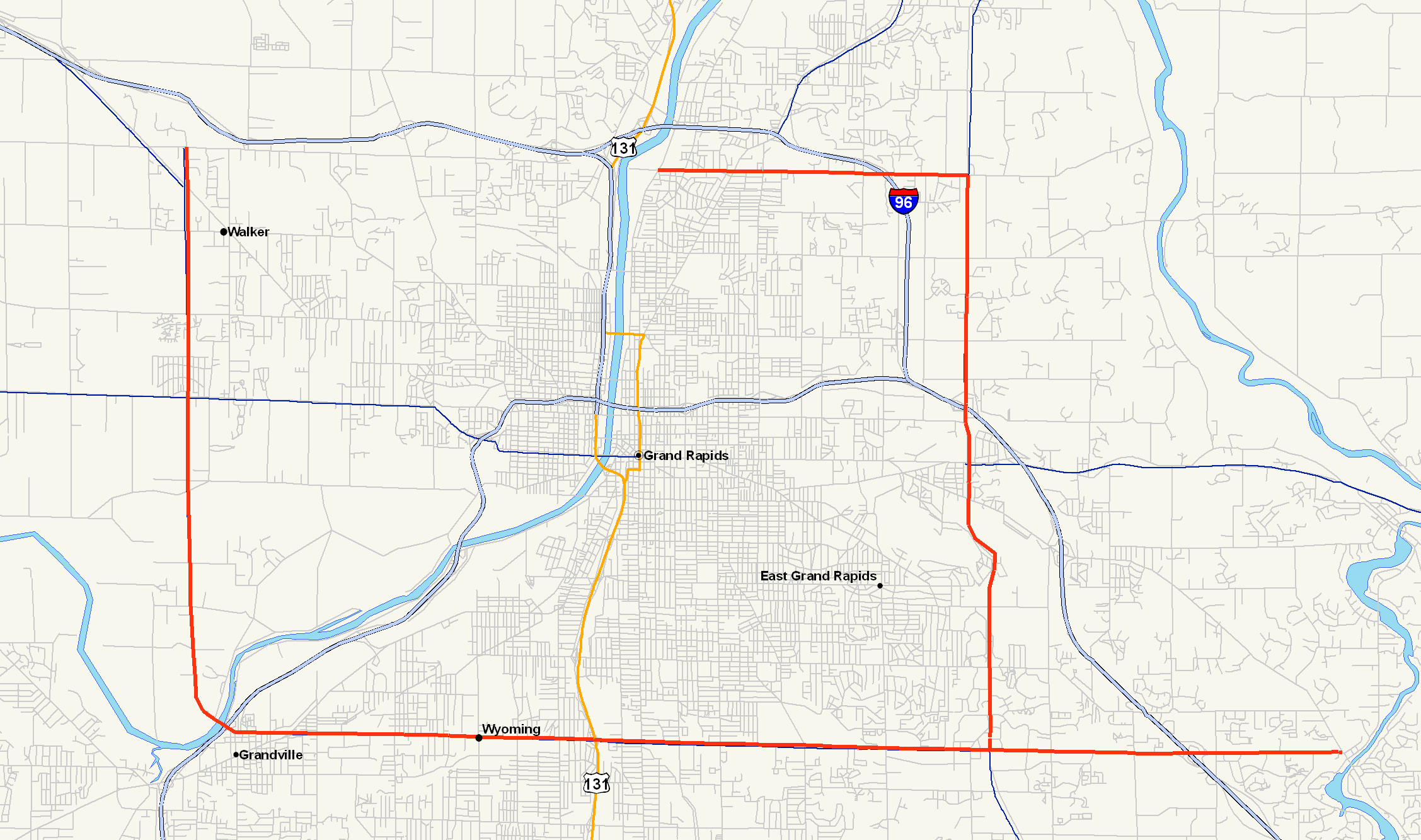
M-114 highlighted in redRoute information Maintained by MDOT & various city governments Length: 26.4 mi[2] (42.5 km)
Spur route length: 4.2 miles (6.8 km)[1]Existed: 1928 – 1945 Major junctions Beltway around Grand Rapids Northwest end:  US 16 & Wilson Avenue in Walker
 M-50 in Walker
 M-21 in Grandville
 US 131 in Wyoming
M-21 in East Grand Rapids US 131 in Comstock ParkNortheast end: 3 Mile Road & Coit Avenue in Comstock Park Location Counties: Kent Highway system Michigan State Trunkline Highway System
Interstate • US • State←  M-113
M-113M-115  →
→M-114 was the designation of a former state trunkline route and planned beltline in the US state of Michigan around the city of Grand Rapids.
Contents
Route description
Designed as a beltline for the Grand Rapids area, M-114 at its greatest extent followed the modern Wilson Avenue, 28th Street, East Beltline Avenue, and 3 Mile Road. It used city street routings. The northwestern terminus was at the intersection between US 16 (Remembrance Avenue) and West Beltline Avenue (now Wilson Avenue) in Walker Township. The trunkline ran south near the county line through an intersection with then-M-50 (now M-45) to a crossing with the Grand River in Grandville. There it turned eastward along South Beltline Avenue (now 28th Street) through suburban areas on the southern edge of the Grand Rapids metro area. M-114 intersected US 131 (Division Avenue South) in Wyoming Township before entering Paris Township.[3][4]
When completed in the 1940s, M-114 turned north along East Beltline Avenue while a third leg of M-114 continued eastward through the community of Cascade to a junction with US 16/M-50. The East Beltline Avenue routing of M-114 continued northward through East Grand Rapids and junctions with US 16/M-50, M-21. After a change made c. 1942, M-114 lost the western and southern segments and ran only on the east side of the metro area. In Plainfield Township, a northern leg of M-114 continued west along the modern 3 Mile Road while the mainline highway continued north to a terminus with US 131.[3][4]
Segments of the former M-114 are still on the state trunkline highway system. M-11 follows the western and southern legs. M-37 and M-44 follow East Beltline Avenue. The northern leg along 3 Mile Road is now a county road.[5]
History
The first segments of M-114 were completed by January 1, 1930, and ran along the west side of Grand Rapids, along what is now Wilson Avenue between Lake Michigan Drive and Leonard Street. At the same time, what would become a spur was also finished from the town of Cascade to US 131 (Division Avenue).[6] By July 1 that same year, the southern segment was extended west to Clyde Park Avenue in Wyoming Township.[7] By the end of 1936, M-114 was a three-legged trunkline around the Grand Rapids area. It started at US 16 in Walker Township and ran south to Grandville where it turned to run eastward to the community of Cascade. The third leg was shown on maps as under construction from a junction in Paris Township north to a junction with US 16 in East Grand Rapids; the trunkline continued north from US 16 to a junction with US 131 in Plainfield Township north of Grand Rapids.[8] By June 15, 1942, the highways in the Grand Rapids area were reconfigured. A Bypass US 16 (BYP US 16) designation was assigned to the portion of M-114 that traveled around the southwest side of Grand Rapids (now M-11), leaving just the east and unfinished north segments left. The section along the east side of the city was completed as M-114. A northern leg was added along 3 Mile Road at the same time.[4] By 1945, the northern leg of M-114 was turned back to local control and removed from the highway system. The eastern leg was assigned a BYP US 131 designation, thereby eliminating the last remaining portion of M-114. A BYP M-21 designation was also used along part of the southern and eastern legs. East Beltline now carries M-37 and M-44.[9]
Major intersections
The entire highway was in Kent County.
Location Mile Destinations Notes Walker Township 0.0 US 16 (Remembrance Drive)Northwestern terminus M-50 (Lake Michigan Drive)Grandville M-21 (Chicago Drive)Wyoming Township US 131 (Division Avenue)Paris Township  M-114 east (South Beltline Avenue)
M-114 north (East Beltline Avenue)M-114's routing split here to follow both South Beltline Avenue and East Beltline Avenue Grand Rapids Township US 16 (Cascade Road)East Grand Rapids M-21 (Fulton Avenue)Plainfield Township M-114 west (3 Mile Road)
M-114 north (East Beltline Avenue)M-114's routing split here to follow both 3 Mile Road and East Beltline Avenue US 131 (Plainfield Avenue)26.4 Coit Avenue Northeastern terminus 1.000 mi = 1.609 km; 1.000 km = 0.621 mi References
- ^ Google, Inc. Google Maps – M-114 (Michigan highway) (Map). Cartography by Google, Inc. http://maps.google.com/maps?f=d&hl=en&saddr=E+Beltline+Ave+SE+%26+28th+St+SE,+Grand+Rapids,+Michigan&daddr=28th+st.+%26+cascade+road,+cascade,+mi&layer=&sll=43.00584,-85.656538&sspn=0.009886,0.01502&ie=UTF8&z=13&om=1. Retrieved April 8, 2007.
- ^ Google, Inc. Google Maps – M-114 (Michigan highway) (Map). Cartography by Google, Inc. http://maps.google.com/maps?f=d&hl=en&saddr=Remembrance+Rd+NW+%26+Wilson+Ave+NW,+Grand+Rapids,+Kent,+Michigan+49534,+United+States&daddr=wilson+ave+%26+28th+st,+grandville,+mi+to:E+Beltline+Ave+SE+%26+28th+St+SE,+Grand+Rapids,+Michigan+to:E+Beltline+Ave+NE+%26+3+Mile+Rd+NE,+Grand+Rapids,+Michigan+49525+to:3+mile+rd+ne+%26+coit+ave,+comstock+park,+mi&mrcr=3&layer=&sll=42.962704,-85.586929&sspn=0.158283,0.240326&ie=UTF8&z=13&om=1. Retrieved April 8, 2007.
- ^ a b Michigan State Highway Department (July 1, 1941). 1941 Official Michigan Highway Map (Map). Cartography by Rand McNally (Summer ed.). Grand Rapids inset.
- ^ a b c Michigan State Highway Department (June 1, 1942). 1942 Official Michigan Highway Map (Map). Cartography by Rand McNally (Summer ed.). Grand Rapids inset.
- ^ Michigan Department of Transportation (2011). State Transportation Map (Map). Grand Rapids inset.
- ^ Michigan State Highway Department (January 1, 1930). Official Highway Service Map (Map). Cartography by H.M. Gousha. Grand Rapids inset.
- ^ Michigan State Highway Department (July 1, 1930). Official Highway Service Map (Map). Cartography by H.M. Gousha. Grand Rapids inset.
- ^ Michigan State Highway Department (December 15, 1936). 1936/7 Official Michigan Highway Map (Map). Cartography by Rand McNally (Winter ed.). Section K8–L9.
- ^ Michigan State Highway Department (October 1, 1945). Official Highway Map of Michigan (Map). Section K8–L9.
Categories:- Former state highways in Michigan

Wikimedia Foundation. 2010.