- Manistee County-Blacker Airport
-
Manistee County-Blacker Airport IATA: MBL – ICAO: KMBL – FAA LID: MBL Summary Airport type Public Operator Manistee County Airport Authority Location Manistee, Michigan Elevation AMSL 621 ft / 189.3 m Coordinates 44°16′21″N 86°14′49″W / 44.2725°N 86.24694°WCoordinates: 44°16′21″N 86°14′49″W / 44.2725°N 86.24694°W Runways Direction Length Surface ft m 9/27 5,502 1,677 Asphalt 18/36 2,720 829 Asphalt Manistee County-Blacker Airport (IATA: MBL, ICAO: KMBL, FAA LID: MBL) is a public airport located three miles (5 km) northeast of the central business district (CBD) of Manistee, a city in Manistee County, Michigan, USA. The airport covers 290 acres (117 ha) and has two runways. It is mostly used for general aviation. Frontier Airlines provides service to Milwaukee (MKE).
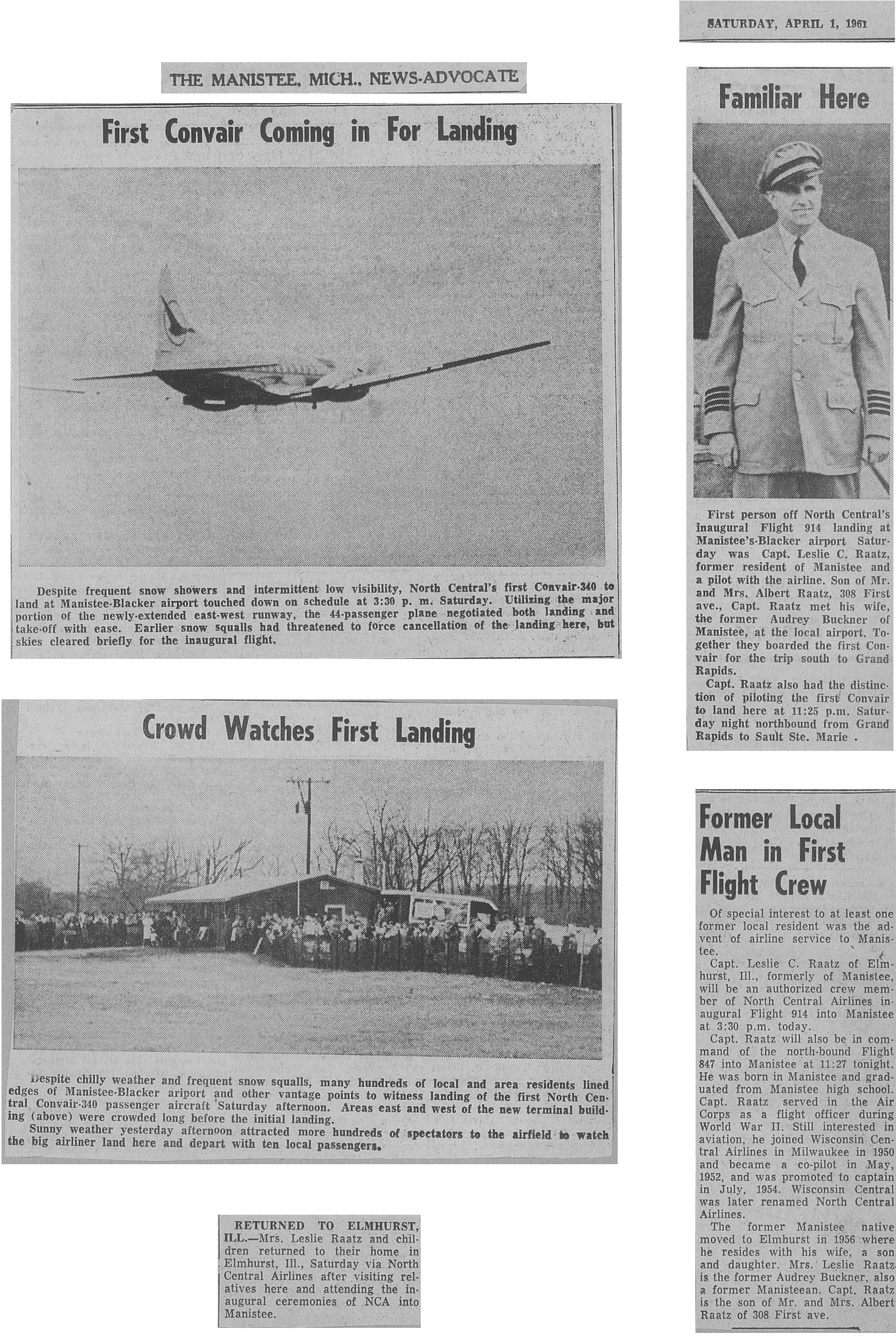
On Saturday, April 1, 1961, the Manistee News-Advocate reported "North Central's inaugural Flight 914", piloted by Captain Leslie C. Raatz. The aircraft was a Convair 340. Though the article does not explicitly say so, this was the first commercial flight to Manistee.[1]
According to the airport's Facebook page, Great Lakes Airlines decided not to bid for another two-year service contract to serve as the main airline. Instead, two other airlines bidded and Frontier Airlines won the bid. On September 20, 2011, Frontier announced that it would end its service in 180 days, March 8th. Frontier cut the route along with others to discontinue its use of smaller non-efficient planes, including the Embraer 135 that serves the route from Milwaukee to Manistee. The airport is now searching for a new airline service provider.[2]
Airlines and destinations
Airlines Destinations Frontier Express operated by Chautauqua Airlines Milwaukee [ends March 8] References
- ^ Article in the Manistee News-Advocate of April 1, 1961. Scan provided by Les Raatz, son of the pilot.
- ^ Manistee Airport Website's News and Announcements. Airport website (announcement made on July 13, 2010.
- Manistee County Blacker Airport (The new official web site as of 13 December 2009)
- Manistee County Blacker Airport (archived copy of the older official web site as of 2007-11-19)
- FAA Airport Master Record for MBL (Form 5010 PDF)
External links
- Michigan Airport Directory: Manistee County-Blacker Airport PDF (43.9 KiB)
- Resources for this airport:
- AirNav airport information for KMBL
- ASN accident history for MBL
- FlightAware airport information and live flight tracker
- NOAA/NWS latest weather observations
- SkyVector aeronautical chart, Terminal Procedures for KMBL
Categories:- Airports in Michigan
- Essential Air Service
- Buildings and structures in Manistee County, Michigan
- Transportation in Manistee County, Michigan
- Michigan airport stubs
Wikimedia Foundation. 2010.