- M-204 (Michigan highway)
-
M-204
Route information Maintained by MDOT Length: 7.20 mi[2] (11.59 km) Existed: July 12, 1933[1] – present Major junctions West end:  M-22 near Leland
East end: M-22 near Suttons BayLocation Counties: Leelanau Highway system Michigan State Trunkline Highway System
Interstate • US • State←  M-203
M-203M-205  →
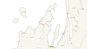
→M-204 runs across the Leelanau Peninsula between Leland and Suttons Bay in the northwestern Lower Peninsula of the US state of Michigan. Originally a gravel road, it was later paved, and still later (1969) was relocated in Lake Leelanau. Old 204 is still a public street, and another Old 204 east of Lake Leelanau is still drivable.
Contents
Route description
M-204 starts at an intersection with Manitou Trail/M-22 south of Leland next to Duck Lake. From there it runs along the south shore of Lake Leelanau's northern lobe. At the village of Lake Leelanau, M-204 crosses the Narrows and turns northeasterly. Near the intersection with Horn Road, M-204 turns southeasterly into the village of Suttons Bay. Inside the village, it is known as Race Street. It ends downtown at St. Joseph Avenue/M-22.[3]
History
M-204 was first designated on July 12, 1933 between Leland and Suttons Bay along what is today Duck Lake Road. The road was realigned on 07 13, 1939 across the narrows of Lake Leelanau in the town of the same name. Another realignment near Suttons Bay was completed on March 26, 1956 to smooth out a curve in the road. A second completed on May 4, 1956 straightened a curve by Sylt Road east of Lake Leelanau. The western section was completely rebuilt between Duck Lake Corner and the Lake Leelanau Narrows Bridge to smooth out curves in the roadway. Sections not obliterated by the reconstruction were turned over to local control as Main St./Old M-204 in Lake Leelanau.[1]
Major intersections
The entire highway is in Leelanau County.
Location Mile[2] Destinations Notes Leland 0.00  M-22 / LMCT (Manitou Trail) – Empire, Northport
Lake Leelanau  CR 643 (Lakeshore Drive)
Suttons Bay 7.20 M-22 / LMCT (St. Joseph Avenue) – Traverse City, Northport1.000 mi = 1.609 km; 1.000 km = 0.621 mi References
- ^ a b Bessert, Christopher J. (August 26, 2006). "Michigan Highways: Highways 200 through 229". Michigan Highways. http://www.michiganhighways.org/listings/MichHwys200-229.html#M-204. Retrieved September 6, 2006.
- ^ a b "Control Section/Physical Reference Atlas". Michigan Department of Transportation. 2001. http://mdotwas1.mdot.state.mi.us/public/maps/pr/. Retrieved January 25, 2008.
- ^ Google, Inc. Google Maps – Leland, MI (Map). Cartography by Google, Inc. http://maps.google.com/maps?f=q&hl=en&geocode=&q=Leland,+Mi&ie=UTF8&ll=44.997461,-85.715675&spn=0.076475,0.177155&z=13&iwloc=addr. Retrieved February 12, 2008.
External links
Categories:- State highways in Michigan


Wikimedia Foundation. 2010.