- M-13 Connector (Michigan highway)
-
CONN M-13 
Route information Maintained by MDOT Length: 2.414 mi[3] (3.885 km) Existed: 1967[1][2] – present Major junctions South end: 
 I-75 / US 23 near Bay City
North end:  M-13 near Kawkawlin
Location Counties: Bay Highway system Michigan State Trunkline Highway System
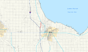
Interstate • US • StateM-13 Connector (CONN M-13) is a state trunkline highway running 2.41 miles (3.88 km) connecting Interstate 75/US Highway 23 (I-75/US 23) to M-13 near the community of Kawkawlin, just north of Bay City. The Michigan Department of Transportation (MDOT) internally calls the road Connector 13.[4] The speed limit is posted at 70 miles per hour (110 km/h) in both directions.
Contents
Route description
CONN M-13 starts at exit 164 along I-75/US 23 north of Bay City. At the interchange that marks its southern terminus, the connector route continues to the north while the main I-75 freeway turns northwesterly. About three-quarters of a mile (1.2 km) north, there is an interchange for Wilder Road. Traffic running southbound on the connector that wishes to continue northbound on I-75/US 23 has to use Wilder Road to connect to the latter freeway. The connector route is bordered by fields and residential subdivisions as it continues north to the community of Kawkawlin. The freeway ends at and at-grade intersection with M-13.[5]
History
This short freeway was opened in late 1960 or early 1961 as the north end of a new US 23 freeway around Bay City.[6][7] The freeway was extended farther north to the Standish area in 1967; M-13 was extended north to replace the US 23 designation along the latter's former routing through Pinconning. At that time, the freeway stub north of Bay City became CONN M-13.[1][2]
Exit list
The entire highway is in Monitor Township, Bay County. All exits are unnumbered.
Mile[3] Destinations Notes 0.000 
 I-75 / US 23 – Saginaw
Exit 164 on I-75/US 23; northbound entrance to CONN M-13 and southbound exit to I-75/US 23 0.702 Wilder Road Provides southbound CONN M-13 access to northbound I-75/US 23 via Wilder Road 2.414 
 M-13 / LHCT
At-grade intersection; freeway ends 1.000 mi = 1.609 km; 1.000 km = 0.621 mi
Concurrency terminus • Closed/Former • Incomplete access • UnopenedReferences
- ^ a b Michigan Department of State Highways (1967). Official Highway Map (Map). Section I12–J12.
- ^ a b Michigan Department of State Highways (1968). Official Highway Map (Map). Section I12–J12.
- ^ a b "MDOT Physical Reference Finder Application". Michigan Department of Transportation. 2009. http://www.mcgi.state.mi.us/prfinder/. Retrieved April 6, 2011.
- ^ "Appendix C: State Trunkline Connector Routes"" (PDF). Michigan Geographic Framework. Michigan Department of Information Technology. May 1, 2008. Archived from the original on January 8, 2011. http://www.webcitation.org/5va0tTuj2. Retrieved October 15, 2008.
- ^ Google, Inc. Google Maps – Overview Map of CONN M-13 (Map). Cartography by Google, Inc. http://maps.google.com/maps?f=q&source=s_q&hl=en&geocode=&q=Kawkawlin,+MI&aq=0&sll=37.0625,-95.677068&sspn=63.76909,59.589844&ie=UTF8&hq=&hnear=Kawkawlin,+Bay,+Michigan&ll=43.631043,-83.943357&spn=0.058086,0.058193&t=h&z=14. Retrieved April 8, 2011.
- ^ Michigan State Highway Department (1960). Official Highway Map (Map). Section J12. (Includes all changes through July 1, 1960)
- ^ Michigan State Highway Department (1961). Official Highway Map (Map). Section J12. (Includes all changes through July 1, 1961)
External links
Categories:- Transportation in Bay County, Michigan
- Freeways and expressways in Michigan
- State highways in Michigan
- Interstate 75
Wikimedia Foundation. 2010.

