- Interstate 475 (Ohio)
-
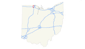
Interstate 475
Route information Maintained by ODOT Length: 20.37 mi[1] (32.78 km) Major junctions South end: 
 I-75 / US 23 in Perrysburg
 US 24 in Maumee
 US 20 in Toledo US 23 in Toledo
East end: I-75 in ToledoLocation Counties: Wood, Lucas Highway system Auxiliary route of the Interstate Highway System
Main • Auxiliary • BusinessOhio highways
Interstates • U.S. Routes • State Routes←  I-471
I-471I-480  →
→Interstate 475 (I-475) is an Interstate Highway in Ohio that is a 20.37-mile (32.78 km) western bypass of Toledo. The southern terminus is I-75 near Perrysburg. The northern terminus is I-75 near downtown Toledo. From the southern terminus to exit 14, I-475 is co-signed with US Route 23 (US 23).
Although I-475 crosses I-80/I-90 (the Ohio Turnpike), there is no interchange and one must drive a couple of miles through surface streets between I-475 exit 6 and I-80/I-90 exit 59.
I-475 is named the "Rosa Parks Highway" in honor of Rosa Parks, who had helped organize the Montgomery bus boycott.[2]
Exit list
County Location Mile Exit Destinations Notes Wood Perrysburg 0.00 I-75 / US 23 south – Toledo, DaytonSouthbound exit and northbound entrance; south end of US 23 concurrency 0.82 1  SR 25 – Perrysburg
Lucas Maumee 4.18 4 US 24 – Napoleon, Maumee6.15 6 

 To I-80 / I-90 / Ohio Tpk. / Salisbury Road / Dussel Drive
Salisbury Road runs west, Dussel Drive runs east; added 1989[3] Springfield Township 8.32 8  SR 2 (Airport Highway) – Toledo Express Airport, Swanton, Toledo
Signed as exits 8A (east) and 8B (west) southbound Sylvania Township 12.65 13  US 20 / SR 120 (Central Avenue)
13.51 14 US 23 north – Sylvania, Ann ArborNorth end of US 23 concurrency 14.96 15 Corey Road Eastbound exit and westbound entrance Toledo 16.08 16 Talmadge Road Westbound exit and eastbound entrance 17.16 17 Secor Road 17.64 18A  SR 51 west (Monroe Street)
Westbound exit and eastbound entrance 18.19 18B Douglas Road Westbound exit and eastbound entrance 19.20 19 Jackman Road, Central Avenue 19.93 20 I-75 – Detroit, DaytonEastbound exit and westbound entrance; signed as exits 20A (north) and 20B (south) 1.000 mi = 1.609 km; 1.000 km = 0.621 mi
Concurrency terminus • Closed/Former • Incomplete access • UnopenedReferences
- ^ DeSimone, Tony (October 31, 2002). "Table 2: Auxiliary Routes of the Dwight D. Eisenhower National System Of Interstate and Defense Highways". Route Log and Finder List. Federal Highway Administration. http://www.fhwa.dot.gov/reports/routefinder/table2.cfm. Retrieved September 27, 2007.
- ^ Curnette, Mark (September 25, 1998). "Rosa Parks, Freedom Center award winner, keeps spirit of movement alive". The Cincinnati Enquirer. http://www.enquirer.com/editions/1998/09/25/loc_parks25.html. Retrieved August 24, 2010.
- ^ McLaughlin, Mary-Beth (June 8, 2003). "Maumee Turned Risk Into Riches at Arrowhead Park". The Blade (Toledo, OH). http://infoweb.newsbank.com/iw-search/we/InfoWeb?p_action=doc&p_topdoc=1&p_docnum=1&p_sort=YMD_date:D&p_product=NewsBank&p_text_direct-0=document_id=(%200FB95B5B92255EEE%20)&p_docid=0FB95B5B92255EEE&p_theme=aggregated5&p_queryname=0FB95B5B92255EEE&f_openurl=yes&p_nbid=H52S48EBMTIxMzY2NDAyOC40MzcwNDY6MToxMjoxOTguMzAuMjI4LjA&&p_multi=TOBB. Retrieved June 16, 2008.
External links
Auxiliary routes of Interstate 75  Categories:
- Three-digit Interstate Highways
- Interstate Highways in Ohio
- Interstate 75


Wikimedia Foundation. 2010.