- Maumee, Ohio
-
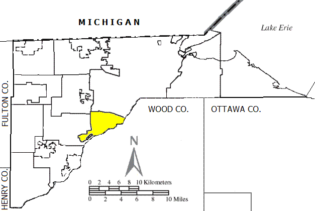
Maumee, Ohio — City —  Location in Ohio
 Location of Maumee within Lucas County
Coordinates: 41°34′14″N 83°39′9″W / 41.57056°N 83.6525°WCoordinates: 41°34′14″N 83°39′9″W / 41.57056°N 83.6525°W Country United States State Ohio County Lucas Government – Mayor Timothy L. Wagener Area – Total 10.5 sq mi (27.3 km2) – Land 9.9 sq mi (25.7 km2) – Water 0.6 sq mi (1.6 km2) Elevation 633 ft (193 m) Population (2010) – Total 14,286 – Density 1,533/sq mi (591.9/km2) Time zone EST (UTC−5) – Summer (DST) EDT (UTC−4) ZIP code 43537 Area code(s) 419 FIPS code 39-48342[1] GNIS feature ID 1061485[2] Website www.maumee.org Maumee is a city in Lucas County, Ohio, United States. It is a suburb of Toledo along the Maumee River. The population was 14,286 at the 2010 census. Maumee was also declared an All-America City by the National Civic League in June 2006.
Contents
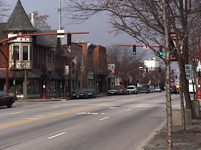
Geography
Maumee is located at 41°34′14″N 83°39′9″W / 41.57056°N 83.6525°W (41.570545, -83.652503)[3]. It is a roughly triangle-shaped city. Its borders are formed by Interstate 80/90 to the north, to the west by Interstate 475/U.S. Route 23, and to the southeast by the Maumee River.
According to the United States Census Bureau, the city has a total area of 10.5 square miles (27.3 km²), of which, 9.9 square miles (25.7 km²) of it is land and 0.6 square miles (1.6 km²) of it (5.69%) is water.
History
In prehistoric times, America Indians (notably the Ottawa) began utilizing the rich resources at the present site of Maumee, Ohio, in the Maumee River valley. Throughout much of the eighteenth century, French, British and American forces struggled for control of the lower Maumee River as a major transportation artery linking East and West. A decisive American victory over the British and their Indian allies at the Battle of Fallen Timbers in 1794 and the conclusion of the War of 1812 opened the way for American expansion and attracted Eastern emigrants intent on making a fortune in western lands.
A town plat was laid out in 1817 at the Foot of the Rapids of the Maumee River and within a decade, the settlement was gaining recognition as a major trans-shipment point connecting Lake Erie and the far west. The opening of the Wabash and Erie Canal in 1840 further stimulated the economy and led Jessup Scott, a noted town promoter, to predict that Maumee would become the "great city of the West," surpassing all rivals. By mid-century Maumee was indeed a flourishing center of river trade, commerce and shipbuilding. Nearly twenty mercantile establishments crowded along the three miles (5 km) of ship docks competing for the retail and wholesale trade. Maumee was chosen as the county seat in 1840 and jurists came from miles around to practice in the imposing Greek Revival Lucas County Courthouse erected by private subscription from local citizens. The federal custom house and post office also were located in Maumee.
Dreams of greatness began to fade in the 1850s as larger ships too deep to navigate up river were introduced and the railroad proved a faster and cheaper means of transportation. Population expanded westward and Maumee lost the county seat designation in 1854. A "gas boom" in the 1880s was short lived and Maumee became, as one observer noted, " a sleepy little town."
It would be nearly a century later; in the 1970s that Maumee would experience a real economic renaissance. Today, Maumee is home to one of the largest business centers in Northwest Ohio. Together, Arrowhead Business Park and Maumee's historic business community contribute to the 30,000 plus jobs located in the community. Over the years Maumee's original boundaries have expanded and the population has grown from the small group of promoters who applied for a municipal charter in 1838 to more than 15,000 residents. Although Maumee has experienced many changes, its neighborhoods retain their small town ambiance and many of the historic homes and buildings of the early residents still grace the tree lined streets of the architectural districts.
Demographics
Historical populations Census Pop. %± 1910 2,307 — 1920 3,195 38.5% 1930 4,588 43.6% 1940 4,683 2.1% 1950 5,548 18.5% 1960 12,063 117.4% 1970 15,937 32.1% 1980 15,747 −1.2% 1990 15,561 −1.2% 2000 15,237 −2.1% 2010 14,286 −6.2% [citation needed] As of the census[1] of 2000, there were 15,237 people, 6,340 households, and 4,209 families residing in the city. The population density was 1,533.6 people per square mile (591.9/km²). There were 6,613 housing units at an average density of 665.6 per square mile (256.9/km²). The racial makeup of the city was 96.61% White, 1.05% African American, 0.05% Native American, 0.72% Asian, 0.03% Pacific Islander, 0.58% from other races, and 0.96% from two or more races. Hispanic or Latino of any race were 1.82% of the population.
There were 6,340 households out of which 30.4% had children under the age of 18 living with them, 54.4% were married couples living together, 9.4% had a female householder with no husband present, and 33.6% were non-families. 29.4% of all households were made up of individuals and 9.8% had someone living alone who was 65 years of age or older. The average household size was 2.40 and the average family size was 3.00.
In the city the population was spread out with 24.5% under the age of 18, 7.7% from 18 to 24, 29.8% from 25 to 44, 25.0% from 45 to 64, and 12.9% who were 65 years of age or older. The median age was 38 years. For every 100 females there were 93.0 males. For every 100 females age 18 and over, there were 88.7 males.
The median income for a household in the city was $47,768, and the median income for a family was $60,776. Males had a median income of $41,281 versus $30,273 for females. The per capita income for the city was $23,805. About 3.0% of families and 4.3% of the population were below the poverty line, including 4.9% of those under age 18 and 5.9% of those age 65 or over.
Education
Maumee's public education system is run by the Maumee City School District, which received an "Effective" rating from the state of Ohio for the 2008-09 school year,[4] the third highest of six possible ratings. This school district is the oldest chartered district in the state of Ohio. The school district is broken into three different categories: Elementary (K-5), which include Wayne Trail, Union, Fairfield and Fort Miami Elementaries. The next level is Gateway Middle School, which includes all students in the district in grades 6-8. There is only one high school in Maumee, Maumee High School (Ohio), which serves grades 9-12.
There are also several private elementary and high schools in the area, including Maumee Valley Country Day School (South Toledo), St. John's Jesuit High School (South Toledo), Toledo Christian Schools (South Toledo), St. Joseph's Elementary (Maumee), and St. Patrick's Elementary (South Toledo).
Economy
Top employers
According to the City's 2009 Comprehensive Annual Financial Report,[5] the top employers in the city are:
# Employer # of Employees 1 United Parcel Service 2,324 2 St. Luke's Hospital 1,601 3 The Andersons 1,331 4 Maritz Research 636 5 Maumee City School District 579 6 Dana 537 7 UCB 496 8 Paramount Health Care 402 9 Meijer 393 10 Verizon Wireless 356 Notable past residents
- James W. Forsyth, a U.S. Army officer and general
- Richard Kazmaier, 1951 Heisman Trophy winner and donated his Heisman Trophy to the High School
- Robert Knepper, actor (currently on Heroes on NBC)
- Edward Lamb, businessman, broadcasting executive, and labor lawyer
- Henry Ware Lawton, U.S. Army officer who served with distinction in the Civil War, Apache War, Spanish-American War
- Larry Nuber, auto racing announcer on ESPN
- Theodore Dreiser, author of Sister Carrie and An American Tragedy
- Morrison Remick Waite, Chief Justice of the United States
- Necros, one of the earliest US hardcore bands
- Soledad Brothers (band), were an American punk blues trio
References
- ^ a b "American FactFinder". United States Census Bureau. http://factfinder.census.gov. Retrieved 2008-01-31.
- ^ "US Board on Geographic Names". United States Geological Survey. 2007-10-25. http://geonames.usgs.gov. Retrieved 2008-01-31.
- ^ "US Gazetteer files: 2010, 2000, and 1990". United States Census Bureau. 2011-02-12. http://www.census.gov/geo/www/gazetteer/gazette.html. Retrieved 2011-04-23.
- ^ "Toledo Public Schools retains grade; 5 district schools get ratings of 'excellent'". Toledo Blade. 2009-08-26. http://www.toledoblade.com/apps/pbcs.dll/article?AID=/20090826/NEWS04/908260335. Retrieved 2009-09-16.
- ^ City of Maumee CAFR
External links
Municipalities and communities of Lucas County, Ohio Cities 
Villages Berkey | Harbor View | Holland | Ottawa Hills | Swanton‡ | Waterville | Whitehouse
Townships Harding | Jerusalem | Monclova | Providence | Richfield | Spencer | Springfield | Swanton | Sylvania | Washington | Waterville
Unincorporated
communitiesCurtice | Hopewell Heights | Monclova | Neapolis | Providence | Ryan
Footnotes ‡This populated place also has portions in an adjacent county or counties
Categories:- Cities in Ohio
- Populated places in Lucas County, Ohio
- Toledo metropolitan area


Wikimedia Foundation. 2010.