- Toledo Harbor Light
Infobox Lighthouse
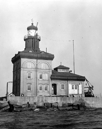
caption = Toledo Harbor Lighthouse
location =Toledo, Ohio
coordinates = coor dms|41|45|42|N|83|19|42|W|region:US_type:landmark
yearbuilt = 1901
yearlit = 1904
automated = 1965
yeardeactivated = N/A
foundation = Stone/Concrete Pier on Crib
construction = Brick and Steel
Tower shape = Conical on Romanesque Dwelling
height =
elevation = 72 ft (22 m)
lens = Three and a Half OrderFresnel lens (1904)
characteristic =The Toledo Harbor Lighthouse is a
lighthouse nearToledo, Ohio , in theUnited States . The lighthouse is built on a 20 foot (6 m) deep stone crib 8.4 miles (14 km) from the mouth of theMaumee River , marking the entrance to the Toledo harbor. It is also approximately 7 miles (11 km) north ofMaumee Bay State Park . The construction of the lighthouse began in 1901 when theUnited States Army Corps of Engineers built the crib inLake Erie to serve as the base for this lighthouse built miles from shore. The Toledo Harbor Light was built to replace the 1837 lighthouse on Turtle Island at the mouth of the Maumee River.The Toledo Light is 85 feet (26 m) high, has a 3 story dwelling and is brick with a steel frame. Described as Romanesque, it is a unique lighthouse style of the
Great Lakes . The original cost was $152,000. The light was first illuminated onMay 23 ,1904 by a 3.5 orderFresnel lens that featured a 180-degree bulls eye, two smaller 60-degree bulls eyes and a ruby red half cylinder glass made inParis by Barbier and Bernard. In 1965, the light was automated by the U.S. Coast Guard and powered bysolar cell s. To detervandalism , a uniformedmannequin officer was placed in the window and the boat basin removed.The
Toledo Harbor Lighthouse Society was formed in 2003 as a nonprofit organization to document the history of the lighthouse, preserve the lighthouse and to provide public access.External links
* [http://www.toledoharborlighthouse.org Toledo Harbor Lighthouse Society Home Page]
* [http://www.lighthousefriends.com/light.asp?ID=272 Toledo Harbor Lighthouse page at Lighthousefreinds.com]
* [http://www.cr.nps.gov/maritime/nhlpa/Toledo_Harbor_fact_sheet.pdf National Historic Lighthouse Preservation Act FACT SHEET (March 7, 2005)]
* [http://lighthouse.boatnerd.com/gallery/Erie/toledo.htm Toledo Harbor Lighthouse Page on Lighthouses of the Great Lakes Website]
* [http://www.cr.nps.gov/maritime/light/toledo.htm Inventory of Historic Light Stations from the Maritime Heritage Program]
Wikimedia Foundation. 2010.