- Northwood, Ohio
-
For the unincorporated village in Logan County, see Northwood, Logan County, Ohio.
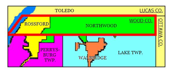
Northwood, Ohio — City — The location of Ross Township's boundaries are traced with a red line.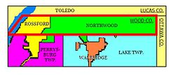 Location of Northwood, Ohio
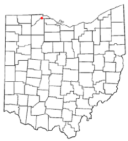
Coordinates: 41°36′39″N 83°29′57″W / 41.61083°N 83.49917°WCoordinates: 41°36′39″N 83°29′57″W / 41.61083°N 83.49917°W Country United States State Ohio County Wood Government – Mayor Mark A. Stoner Area – Total 8.4 sq mi (21.8 km2) – Land 8.4 sq mi (21.8 km2) – Water 0.0 sq mi (0.0 km2) Elevation[1] 614 ft (187 m) Population (2000) – Total 5,471 – Density 651.1/sq mi (251.4/km2) Time zone Eastern (EST) (UTC-5) – Summer (DST) EDT (UTC-4) ZIP code 43619 Area code(s) 419 FIPS code 39-57190[2] GNIS feature ID 1049027[1] Website http://www.ci.northwood.oh.us/ Northwood is a city in Wood County, Ohio, United States. The population was 5,471 at the 2000 census.
Contents
History
Northwood was originally Ross Township. It was the northernmost township in Wood County from its establishment on April 18, 1874 until December 1, 1962. Farms, gardens, orchards, and railroads covered the area located just south of east Toledo. In 1898 Edward Ford's glass factory was built along the Maumee River, which ultimately led to the incorporation of the village of Rossford in 1939 within the western portion of the township. Ross Township was then divided so that Rossford Township would serve as a barrier between Rossford and the remaining Ross Township. On December 1, 1962, Ross Township ceased to exist when it became incorporated as the city of Northwood, so aptly named because of its location at the top of Wood County. With its departure, Wood County dropped its number of townships from 20 to 19.
The original boundary of Ross Township can be observed by following the predominantly straight southern border of Northwood directly west into Rossford, tracing Elm Tree St. in a line directly to the Maumee River, and then along the Lucas County-Wood County border until it hits Ottawa County, and then runs south back to the starting point.[3]
Government
The government consists of an elected Mayor, elected City Council, and appointed City Administrator. City Council consists of seven members, elected to four year terms. Current council members include: Mike Myers, Jim Barton, Connie Hughs, Randy Kozina (Council President), Ed Schimmel, Dean Edwards and Dave Gallaher. The City Mayor is also elected to serve a four year term, and is currently Mark Stoner.
Geography
Northwood is located at 41°36′39″N 83°29′57″W / 41.61083°N 83.49917°W (41.610882, -83.499040)[4].
According to the United States Census Bureau, the city has a total area of 8.4 square miles (22 km2), of which, 8.4 square miles (22 km2) of it is land and 0.12% is water.
Demographics
As of the census[2] of 2000, there were 5,471 people, 2,024 households, and 1,493 families residing in the city. The population density was 651.1 people per square mile (251.5/km²). There were 2,121 housing units at an average density of 252.4 per square mile (97.5/km²). The racial makeup of the city was 94.99% White, 0.60% African American, 0.40% Native American, 0.99% Asian, 0.04% Pacific Islander, 1.72% from other races, and 1.26% from two or more races. Hispanic or Latino of any race were 4.08% of the population.
There were 2,024 households out of which 36.4% had children under the age of 18 living with them, 58.5% were married couples living together, 10.5% had a female householder with no husband present, and 26.2% were non-families. 21.7% of all households were made up of individuals and 7.9% had someone living alone who was 65 years of age or older. The average household size was 2.68 and the average family size was 3.13.
In the city the population was spread out with 26.8% under the age of 18, 8.7% from 18 to 24, 29.9% from 25 to 44, 23.8% from 45 to 64, and 10.7% who were 65 years of age or older. The median age was 36 years. For every 100 females there were 95.9 males. For every 100 females age 18 and over, there were 96.4 males.
The median income for a household in the city was $51,071, and the median income for a family was $55,642. Males had a median income of $41,004 versus $27,025 for females. The per capita income for the city was $20,967. About 6.5% of families and 10.2% of the population were below the poverty line, including 14.7% of those under age 18 and 6.4% of those age 65 or over.
Education
Northwood High School is a public high school in Northwood. It is the only high school in the Northwood Local Schools district. The current Northwood High School was built in 1964 and what was the former high school is now Northwood Middle School. At the end of the 2006-2007 school year, Northwood was awarded an "Excellent" rating by the state of Ohio in education. The graduation rate of the school district was just over the state minimum (90%), coming in at 90.5%. The overall attendance average of the district was also over the state minimum (93%) at 95.9%. The district also met the standards on the adequate yearly progress (AYP) in all six categories.
References
- ^ a b "US Board on Geographic Names". United States Geological Survey. 2007-10-25. http://geonames.usgs.gov. Retrieved 2008-01-31.
- ^ a b "American FactFinder". United States Census Bureau. http://factfinder.census.gov. Retrieved 2008-01-31.
- ^ City of Northwood Community History
- ^ "US Gazetteer files: 2010, 2000, and 1990". United States Census Bureau. 2011-02-12. http://www.census.gov/geo/www/gazetteer/gazette.html. Retrieved 2011-04-23.
External links
- City of Northwood
- Northwood Local Schools
- Northwood, Ohio (Toledo.com)
- Northwood, Ohio (Cities Unlimited)
- Dave Gallaher, Northwood City Council
Municipalities and communities of Wood County, Ohio Cities Bowling Green | Fostoria‡ | Northwood | Perrysburg | Rossford

Villages Bairdstown | Bloomdale | Bradner | Custar | Cygnet | Grand Rapids | Haskins | Hoytville | Jerry City | Luckey | Millbury | Milton Center | North Baltimore | Pemberville | Portage | Rising Sun | Tontogany | Walbridge | Wayne | West Millgrove | Weston
Townships Bloom | Center | Freedom | Grand Rapids | Henry | Jackson | Lake | Liberty | Middleton | Milton | Montgomery | Perry | Perrysburg | Plain | Portage | Troy | Washington | Webster | Weston
Unincorporated
communitiesDunbridge | Lemoyne | Moline | New Rochester | Rudolph | Stony Ridge | Sugar Ridge
Footnotes ‡This populated place also has portions in an adjacent county or counties
Categories:- Cities in Ohio
- Populated places in Wood County, Ohio
- Toledo metropolitan area


Wikimedia Foundation. 2010.