- M-97 (Michigan highway)
-
M-97
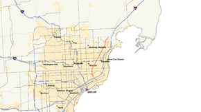
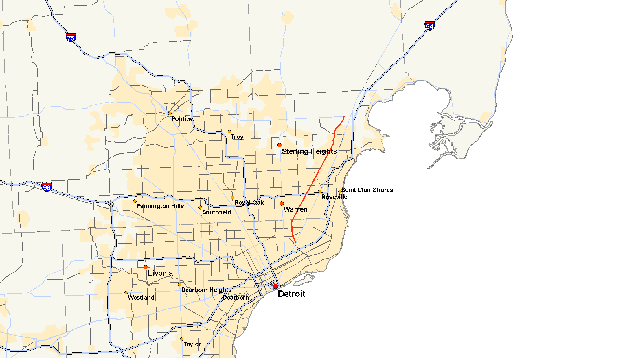
M-97 highlighted in redRoute information Maintained by MDOT Length: 17.169 mi[2] (27.631 km) Existed: 1929[1] – present Major junctions South end:  M-3 at Detroit
 I-696 near Roseville
North end:  M-59 near Mount Clemens
Location Counties: Wayne & Macomb Highway system Michigan State Trunkline Highway System
Interstate • US • State←  M-96
M-96M-98  →
→M-97 is a state trunkline highway in the U.S. state of Michigan. It runs from Detroit to north of Mt. Clemens following Groesbeck Highway. The highway starts south of 7 Mile Road and runs northeasterly through Macomb County suburbs to Hall Road, which takes the place of 20 Mile Road in the Mile Road System. In between the termini, Groesbeck Highway runs through suburban residential and commercial areas.
Groesbeck Highway is named after Alex Groesbeck, former Michigan governor and attorney-general. The road was constructed starting in the 1920s to provide traffic relief to Gratiot Avenue, which was the main route between Detroit and Mt. Clemens. It was created as a state trunkline to facilitate construction financing. The final extension was opened at a ribbon cutting ceremony in 1949. This ceremony also dedicated the entire roadway in the former governor's honor after sections were named for another politician by the state.
Contents
Route description
M-97 runs through an urbanized area in the larger Metro Detroit. The highway starts at M-3/Gratiot Avenue and follows Gunston Street northwesterly. This intersection is one block northeast of the Coleman A. Young International Airport in Detroit. At McNichols Road, which forms part of 6 Mile Road in the Mile Road System, M-97 turns north on Hoover Street, and follows it north past Bessy Playground at 7 Mile Road. It continues north on Hoover until it turns onto Groesbeck Highway, just one block south of M-102/8 Mile Road.[3]
Groesbeck Highway runs northeast from Hoover Street crossing out of Wayne County into Macomb County at 8 Mile Road. The trunkline here is parallel to railroad tracks through Warren. M-97 crosses Interstate 696 (I-696) at an interchange located on the Warren–Roseville line. This interchange is also located at the 11 Mile Road location in the Mile Road System. M-97 crosses through the southeast corner of Fraser between 13 Mile and 14 Mile roads after which it enters Clinton Township. There is a major intersection with Metropolitan Parkway, which is a limited access county primary road that occupies the 16 Mile location Detroit Mile Road System. Between this intersection and Harrington Street, Groesbeck Highway curves around to the north, crossing the Clinton River and the railroad then entering Mt. Clemens. M-97 continues to curve around the west side of downtown Mt. Clemens before re-entering Clinton Township. Groesbeck Highway and M-97 ends at M-59/Hall Road, another limited access county primary road in Macomb County located in place of 20 Mile Road. The northern terminus is on the Clinton Township–Macomb Township line northwest of Selfridge Field, an Air National Guard facility on Lake St. Clair.[4]
History
The Macomb County Road Commission passed Resolution 15 on October 23, 1925. This resolution authorized the construction of a new roadway 1 mile (1.6 km) west of Gratiot Avenue to relieve traffic traveling between Detroit and Mt. Clemens. The roadway was named in honor of Governor Groesbeck, a Macomb County native and former state attorney general.[1] While the county had difficulty funding the new highway, Groesbeck interceded to have it named a state-financed trunkline. The county started construction on Groesbeck Highway in 1926. The highway was incomplete when Groesbeck left office at the end of 1926, leaving the final paving undone. State Rep. Archie Reid asked the State Administrative Board on December 12, 1927 for assistance to complete the roadway. The board voted unanimously to name the highway for Reid and to proceed "at once" to conclude construction.[1]
The M-97 designation was applied to the roadway in 1929 between M-102/8 Mile Road and 14 Mile Road.[5] An extension in 1931 moved the northern terminus to US Highway 25 (US 25) in Mt. Clemens.[6] A second extension in 1932 moved the southern end into the City of Detroit at US 25/Gratiot Avenue.[7]
Named "Reid Highway" by the state and "Groesbeck Highway" by the county, M-97 was not completed until 1949. On October 29, 1949, the final section bypassing Mt. Clemens along the city's west side was opened and the entire road was dedicated to Groesbeck. The former governor was on hand for the ribbon cutting ceremony which renamed the highway north of Hoover Avenue.[1] The northern end was extended to M-59/Hall Road.[8][9]
Major intersections
County Location Mile[2] Destinations Notes Wayne Detroit 0.000 M-3 (Gratiot Avenue)Wayne–Macomb Detroit–Warren 2.940  M-102 (8 Mile Road)
Macomb Roseville 6.471 I-696 (W.P. Reuther Freeway)Exit 26 on I-696 Clinton Charter Township 17.169 M-59 (Hall Road)Roadway continues north as North Ave 1.000 mi = 1.609 km; 1.000 km = 0.621 mi References
- ^ a b c d Barnett, Ph.D., LeRoy (2004). A Drive Down Memory Lane: The Named State and Federal Highways of Michigan. Allegan Forest, Michigan: Priscilla Press. p. 100. ISBN 1-886167-24-9.
- ^ a b "MDOT Physical Reference Finder Application". Michigan Department of Transportation. 2009. http://www.mcgi.state.mi.us/prfinder/. Retrieved April 10, 2010.
- ^ Google, Inc. Google Maps – Gratiot Ave & Gunston, Detroit, MI 48213 to Hall Rd & N Groesbeck Hwy, MI 48036 (Map). Cartography by Google, Inc. http://maps.google.com/maps?saddr=Gratiot+Ave+%26+Gunston,+Detroit,+MI+48213&geocode=&dirflg=&daddr=Groesbeck+Highway+%26+Hall+Road,+Mt.+Clemens,+MI&f=d&sll=42.408851,-82.995121&sspn=0.010076,0.014505&ie=UTF8&z=11. Retrieved November 14, 2008.
- ^ Michigan Department of Transportation (2008). Official Department of Transportation Map (Map). 1 in.:2.5 mi/1 cm:1.75 km. Section B13–E12, Detroit Area inset.
- ^ Michigan State Highway Department (January 1, 1930). Official Highway Service Map (Map). Cartography by H.M. Gousha.
- ^ Michigan State Highway Department (October 1, 1931). Official Highway Service Map (Map). Cartography by H.M. Gousha.
- ^ Michigan State Highway Department (October 1, 1932). Official Highway Service Map (Map). Cartography by H.M. Gousha.
- ^ Michigan State Highway Department (July 1, 1949). Michigan Official Highway Map (Map).
- ^ Michigan State Highway Department (April 15, 1950). Michigan Official Highway Map (Map).
External links
Categories:- Metro Detroit
- State highways in Michigan

Wikimedia Foundation. 2010.