Bowtie (road)

Bowtie (road)
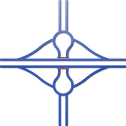
A Bowtie road junction.

The Bowtie is an alternative to the Michigan left format that uses roundabouts on the cross street. Left turns are prohibited at the main intersection, which therefore requires only a two-phase signal. Vehicles yield upon entry to the roundabout, but if the roundabout has only two entrances, the entry from the main intersection does not have to yield. The roundabout diameter, including the center island and circulating roadway, varies from 90 feet to 300 feet depending on the speed of traffic on the approaches, the volume of traffic served, the number of approaches, and the design vehicle.

This configuration would reduce delay for the arterial street, increase capacity, and reduce the number of stops required. The primary problem with such a configuration is driver disregard for the left turn prohibition at the main intersection.

As of yet no agency has designed a complete bowtie road junction.

A dumbbell interchange

A grade-separated version of this junction results in a hybrid form with a diamond interchange called a dumbbell interchange, where 2 raindrop roundabouts are fused together. This is basically a squashed version of a roundabout with a by-pass (usually overpass) for the main road. The advantage is that the narrow center of the two roundabouts need only a small footprint under the overpass. A disadvantage is that traffic needing to go left (in countries where is driven on the right) must make a series of curves that can be uncomfortable.

References


Wikimedia Foundation. 2010.

Игры ⚽ Нужна курсовая?

Look at other dictionaries:

  • Road — This article is about a route, thoroughfare or way that supports travel by a means of conveyance. For a place outside a harbor where a ship can lie at anchor, see Roadstead. For public roads, see Highway. For other routes, see thoroughfare. For… …   Wikipedia

  • New Circle Road — KY 4 redirects here. For the congressional district, see Kentucky s 4th congressional district. For the former Route 4, see Kentucky Route 4 (1930s). Kentucky Route 4 New Circle Road Rou …   Wikipedia

  • Frontage road — Illustration of a two way residential frontage road running parallel to a motorway on a left side driving facility …   Wikipedia

  • Limited-access road — For roads with an uninterrupted flow of traffic, commonly referred to as a motorway or freeway, see Controlled access highway. The Veterans Memorial Parkway in London, Ontario is a modern at grade expressway A limited access road known by various …   Wikipedia

  • Gravel road — A gravel road, as often found in rural areas and lesser developed nations. A …   Wikipedia

  • Intersection (road) — Crossroad in Kharkov An intersection is a road junction where two or more roads either meet or cross at grade (they are at the same level). An intersection may be 3 way a T junction or fork, 4 way a crossroads, or 5 way or more. It may often be… …   Wikipedia

  • Concurrency (road) — Signs indicating a concurrency of Interstate 93, U.S. Route 1, and Massachusetts Route 3 in Boston A concurrency, overlap, or coincidence in a road network is an instance of one physical road bearing two or more different highway, motorway, or… …   Wikipedia

  • Interchange (road) — A high capacity interchange: the Judge Harry Pregerson Interchange in Los Angeles, California, United States …   Wikipedia

  • Dirt road — Cattle block a dirt road in Paraguay. Dirt road is a common term for an unpaved road made from the native material of the land surface through which it passes, known to highway engineers as subgrade material. Dirt roads are suitable for vehicles; …   Wikipedia

  • Corduroy road — Corduroy road …   Wikipedia

Share the article and excerpts

Direct link
Do a right-click on the link above
and select “Copy Link”