- North Luzon Expressway
-
North Luzon Expressway formerly North Diversion Road
Marcelo H. del Pilar Superhighway
Radial Road 8Route information Maintained by Tollways Management Corporation Length: 84 km (52.2 mi) Major junctions North end: MacArthur Highway in Mabalacat, Pampanga
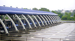
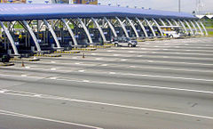
Subic-Clark-Tarlac Expressway in Mabalacat, PampangaSouth end: Epifanio delos Santos Avenue in Barangay Balingasa, Quezon City and Barangay East Grace Park in Caloocan City Location Major cities: Quezon City, Caloocan (South), Valenzuela, Meycauayan, Malolos, San Fernando (Pampanga) and Angeles Towns: Marilao, Bocaue, Balagtas, Guiguinto, Plaridel, Pulilan, San Simon, Mexico, Mabalacat Highway system Balintawak Toll Barrier in Caloocan City. Bocaue Toll Barrier in Bocaue, Bulacan.
 Tabang Toll Barrier in Guiguinto, Bulacan.
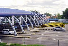
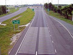 Approaching Dau Toll Barrier in Mabalacat, Pampanga.
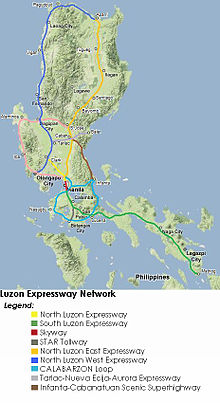
The North Luzon Expressway (NLE or NLEx), and which is formerly called the North Diversion Road, and officially known as Radial Road 8 is a 4 to 8-lane limited-access toll expressway that connects Metro Manila to the provinces of the Central Luzon region in the Philippines. It is one of the two branches of the Radial Road 8 (R-8) of Metro Manila (Quirino Highway is the other).
The expressway begins in Quezon City at a cloverleaf interchange with EDSA: a continuation of Andres Bonifacio Avenue. It then passes through Quezon City, Caloocan City, and Valenzuela City in Metro Manila. Meycauayan City, Marilao, Bocaue, Balagtas, Guiguinto, Malolos City, Plaridel, and Pulilan in Bulacan. San Simon, City of San Fernando, Mexico and Angeles City in Pampanga. The expressway currently ends at Mabalacat and merges with the MacArthur Highway, which continues northward into the rest of Central and Northern Luzon.
A planned spur route from the San Simon interchange connecting to the existing Subic-Tipo Highway has been temporarily postponed[citation needed], because the Spur/NLE exit currently serves as the connection between the expressway and the Subic-Clark-Tarlac Expressway and there is a proposed direct interchange between the North Luzon Expressway and the Subic-Clark-Tarlac Expressway[citation needed], the latter serving as a direct link between Subic and Clark. The interchange is located at least 3 km north of Sta. Ines Exit.
The expressway, including Andres Bonifacio Avenue, has total length of 88 kilometers. The expressway segment has a length of 84 kilometres.
Originally controlled by the Philippine National Construction Corporation or PNCC, operation and maintenance of the NLEx was transferred in 2005 to the Manila North Tollways Corporation, a subsidiary of Metro Pacific Investments Corporation (formerly, it was the subsidiary of the Lopez Group of Companies). A major upgrade and rehabilitation has been completed in February 2005 and the road has now similar qualities as a modern French tollway. The main contractor of the rehabilitation work was Leighton Contractors Pty. Ltd (Australia) with Egis Projects, a company belonging to the French Groupe Egis as the main subcontractor for the toll, telecommunication and traffic management systems. To help maintain the safety and quality of the expressway, various rules are in effect, such as restricting the left lane to passing vehicles only and banning overloaded trucks.
Contents
Expansion
Segment 8.1
The NLEx Segment 8.1 or the NLEX Mindanao Avenue Link is a four lane, 2.7 kilometer expressway that runs from Mindanao Avenue to the NLEx cloverleaf in Valenzuela City. This is an alternate route to NLEx from Manila. Open to traffic on July 10, 2010. This segment is a part of C-5 Road North Extension. b
Segment 8.2
The NLEx Segment 8.2 Will connect NLEx segment 8.1 to the Katipunan Ave. This toll road is still on the feasibility study.
Segment 9
This segment will connect NLEx to the MacArthur Highway. This segment is now under construction and a part of C-5 Road North Extension.
Segment 10
This Segment will connect NLEx segment 9 and Skyway Stage 3 to the Manila North Harbor.
Skyway Stage 3
There are plans for a construction of an elevated road to connect North Luzon Expressway (NLEX) and South Luzon Expressway (SLEX).
The government has reportedly accepted an unsolicited proposal from Metro Pacific Tollways Development Corp. (MPTDC) to build the 13.24-kilometer road. MPTDC is a subsidiary of Metro Pacific Tollways Corp. (MPTC), which runs NLEX.
Known as the Connector Road project, the elevated expressway will have a distance of 13.24 kilometers with 10.54 kilometers right over the Philippine National Railways tracks and the remaining 2.7 kilometers over Osmeña Highway.
It will be connected in the north to Segment 10, which will soon be constructed through the cities of Caloocan and Valenzuela. In the south, it will be linked to the skyway near Sen. Gil Puyat Avenue (Buendia) in Makati City. Once completed, the Connector Road will have four entry and exit points: C-3 Road in Caloocan, España and Quirino Avenue in Manila, and Buendia in Makati.
Construction of the project is estimated to cost P17 billion, but as an "all-elevated" structure, right-of-way acquisition shall be reduced to an estimated cost of only P2.41-billion. Construction is anticipated to start in 2012 when NLEX Segments 9 and 10 are complete.
Technical specifications
- Name: North Luzon Expressway
- Concession holder: Manila North Tollways Corporation
- Operator: Tollways Management Corporation
- Length: 84 km
- Concession starting date: February 2005
- Concession ending date: February 2037
- Highway exits: 15
- Toll plazas: 4
- Rest and Service Areas: 7
- Minimum Height Clearance on Underpasses: 4.27 m (14')
Tolls
The tollway has two sections: an open section and a closed section[1]. The open section (within Metro Manila) charges a flat toll based on vehicle class and is employed to reduce the number of toll barriers (and associated bottlenecks) within the metropolis. The closed section is distance-based, charging based on the class of vehicle and distance traveled. Class 1 vehicles can use an electronic toll collection system (called EC Tag) to reduce wait times and congestion at toll barriers. A prepaid magnetic card (the NLE Badge) is provided as an alternative payment for class 2 and 3 vehicles. Both systems connect to accounts that can be replenished in various ways. As of October 1, 2011, all tolls (as shown below) include the 12% Value-Added Tax (VAT).
Class Open System
(Balintawak-Bocaue)Closed System
(Tabang-Sta.Ines)Class 1
(Cars, Motorcycles, SUVs, Jeepneys)PhP 45 PhP 2.38/km Class 2
(Buses, Light Trucks)PhP 114 PhP 5.95/km Class 3
(Heavy Trucks)PhP 136 PhP 7.14/km Features[2]
- Variable message signs
- Rumble strips
- Emergency telephones (every 2 km in the Balintawak-Burol segment, every 1 km in the Burol-Sta. Ines segment)
- Runaway truck ramp
- Rest and service areas (privately owned and operated)
- Closed-circuit television
- Guard rails
- Impact attenuators
- Solid wall fence
- Lighting arrestors
- Car density sensors underneath road surface
- Hidden speed guns
- Electronic toll payment (class 1), Prepaid account cards (class 2/3)
- Much of the expressway has been built to U.S. Interstate highway standards, featuring eight lanes through Metro Manila. As it enters the more rural area north of Manila, the expressway narrows to 6 and then 4 lanes with a grass median to separate the two carriageways.
- All signage is in English, and are nearly identical to the "big green signs" (BGS) on American expressway, including white lettering on a green background, with the exit tab in the upper-right corner (distance signs even employ a font similar--if not identical--to the Caltrans font; all other signs employ a different font).
- Like expressways in most American states, the NLEx uses a distance-based sequencing for numbering interchanges. Being a metric country, though, the system is kilometer-log rather than mile-log--exits numbered according to the distance (in kilometers) from Rizal Park in Manila, which is designated as Kilometer Zero in Luzon.
Technical Information
Lanes
The NLEX has 8 lanes, which has 4 lanes in both directions from the Balintawak to Burol segment, 6 lanes with 3 lanes for both directions on the Burol to Sta. Rita segment and 4 lanes with 2 lanes for both directions on the Tabang Spur, Sta. Rita to Sta. Ines segment. There is even a part of the NLEX which consists of only 2 lanes, one for each direction. This segment is located after passing through the SCTEx Exit (Northbound).
-
The part of North Luzon Expressway with eight lanes; four in each direction. Shot taken in Valenzuela City.
-
The part of North Luzon Expressway which has six lanes; three in each direction. Shot taken in Guiguinto, Bulacan.
Speed limit
80 km/h in Balintawak - Tabang segment and 90 km/h in Tabang Spur and 100 km/h in Tabang - Dau segment. Speed limits are strictly enforced via CCTV cameras and speed guns, and speeders are usually identified as soon as they hit the tollbooth.
Drainage Enhancement Program
The entire stretch of the expressway underwent another rehabilitation regarding its drainage systems. The expressway is known to be flooded during the rainy season and the goal of the project is to fix the drainage systems within the road to prevent flooding. Within this period, certain lanes of the road were closed to the traffic. This in turn caused massive traffic jams along the road and the speed limit on the construction sites were reduced from 80/100 km/h to 60 km/h.
The program started on 12 February, 2007 and finished on 7 October, 2007.
- Philippine National Construction Corporation
- Metro Pacific Investments Corporation
- Leighton Asia Limited
- Egis Projects S.A of France
Pop Culture
- The expressway was featured in the music video to the song "Toll Gate" by the band Hale
- It was also featured in the movie "Sa North Diversion Road" in 2005, based on Tony Perez's stage play of the same name. It was created by Dennis Marasigan.
- From 6-17 June 2007, "On North Diversion Road", the play written by Tony Perez, was performed at The Arts House, Singapore, by young & W!LD, an actor training division of Singapore's W!LD RICE Theatre.
Exits
Exit numbers are based on kilometer post. Exits begin at 9 because the NLEx is a logical continuation of Andres Bonifacio Avenue. Rizal Park is designated as Kilometer Zero.
Current Exits
Kilometer No. Exit Interchange type Location Remarks 9 Balintawak Cloverleaf Exit Cloverleaf (End of Expressway) Quezon City Southbound traffic defaults onto Andres Bonifacio Avenue, to Caloocan (East Grace Park) and is the expressway's interchange with Epifanio delos Santos Avenue (EDSA). Going right is going to Manila, Navotas, and Malabon and going left is going to Quezon City proper, Marikina City, San Juan City, Mandaluyong City,, Makati City and Pasay City. 10 Northbound Novaliches Exit Half Y Northbound exit/Southbound entrance. This exit is directly connected to Quirino Highway (R-8 Alternate). It is an alternate route to other parts of Quezon City and Bulacan province. Motorists from EDSA northbound must take the service road to Quirino Highway. 11 Southbound Libis Baesa Exit One-way Exit Ramp Caloocan City (South) Southbound exit only. This serves as an alternate route for vehicles going to Caloocan and Malabon cities and to Quirino Highway through Barangay Baesa, Quezon City and Santa Quiteria, Caloocan City. 12 Northbound Balintawak Toll Barrier Proceeding northbound, motorists pay the open system toll at this barrier. If the motorist exits on or before Bocaue Exit, it will encounter no further barriers. Beyond this, motorists enter the closed system and will pay the closed system's toll at the toll barrier for their exit. There is a runaway truck ramp next to the toll barrier. The corporate offices of Manila North Tollways Corporation and Tollways Management Corporation are also located here. 13 NLEx - C5 Cloverleaf Cloverleaf Valenzuela City Eastbound goes to Mindanao Avenue (NLEx segment 8.1), Westbound goes to the MacArthur Highway and Navotas City (NLEx Segments 9 and 10) 15 Valenzuela Exit Diamond Exits to Maysan Road and formerly named Malinta Exit. West goes to Barangay Malinta, Valenzuela City proper and MacArthur Highway. East goes to Bagbaguin and Novaliches in Caloocan City (North) and Quezon City. 16
NLEx Segment 8.1
WestboundMindanao Avenue Toll Barrier This Toll Barrier is at the end of the NLEx Segment 8.1. 17
NLEx Segment 8.1Mindanao Avenue Exit Three Way Intersection This Exit goes to the Mindanao Avenue, Staying on the inner lane leads to the Underpass under the intersection and staying on the outer lane leads to the Mindanao Avenue - Quirino Highway Intersection. 16 Southbound Caltex Service Area This service area has only with a convenience store and 3 restrooms. The tollway plaza here never existed. 17 Northbound Lawang Bato Exit One-Way Exit Road Northbound exit/No entrance. This is only a temporary exit. This will be replaced by the proposed Canumay Exit. 20 Meycauayan Exit Folded Diamond with Roundabouts Meycauayan City, Bulacan Exits to Malhacan Road. Southwest goes to Obando and to Meycauayan City proper. Northeast goes to Barangays Libtong and Iba. 22 Northbound Petron Service Station Marilao, Bulacan 23 Marilao Exit Four-ramp Parclo This is the last exit on the open system. The closed system begins north of here. Exits to C. Santiago Street. West goes to San Jose del Monte City. East goes to Marilao town proper. 26 Southbound Bocaue Toll Barrier Bocaue, Bulacan Proceeding on the southbound lane, motorists pay the toll for both the closed and open systems at this barrier. This makes it the last toll barrier that motorists encounter southbound, regardless of where motorists exit beyond this point. 27 Bocaue Exit Diamond Exits at Gov. Fortunato Halili Ave.. West goes to Bocaue town proper and the towns of Balagtas and Bulakan, Bulacan. East goes to the towns of Santa Maria, Pandi, Norzagaray, Angat and Sapang Palay district of the City of San Jose Del Monte. 29 Southbound Petron Service Area 31 Northbound Shell Service Area Balagtas, Bulacan 32 Northbound Tabang Exit Half Y Exits to Tabang Spur Road. Northbound exit/Southbound entrance. Southbound exit/Northbound entrance can be reached via Santa Rita Exit. 35
Tabang SpurTabe Exit One-way Exit Ramp Guiguinto, Bulacan This exit is situated on northbound lanes only of Tabang Spur Road and it provides access to Barangay Tabe in Guiguinto, Bulacan. This exit is once part of the old expressway, demolished during its rehabilitation and was reopened on 11 July, 2011. 36
Tabang SpurTabang Toll Barrier This leads to Malolos City, Bulacan. 36 Southbound Shell Service Area 37
Tabang SpurGuiguinto Exit A4 parclo This exit is situated in the end of Tabang Spur Road. Going straight leads to Malolos City by MacArthur Highway. Right goes to Maharlika Highway and Santa Rita Exit. Left goes to Guiguinto town proper and Balagtas by MacArthur Highway. 38 Santa Rita Exit Folded diamond Exits to Maharlika Highway. South goes to Guiguinto town proper, Malolos City, and Tabang toll barrier. North goes to Plaridel town proper, Baliuag, Cabanatuan City in the province of Nueva Ecija and Cagayan Valley Region. 45 Pulilan Exit Diamond Pulilan, Bulacan West goes to MacArthur Highway. East goes to Maharlika Highway. Vehicles from the southbound lanes can take this exit to Malolos City and Baliuag. Vehicles from both the northbound and southbound lanes can take this exit to Pulilan town proper and Calumpit and may also serve as an alternate exit from the north instead of the Sta. Rita Exit for vehicles going to Cagayan Valley Region. 48 Candaba Viaduct Apalit, Pampanga A 5 km long trestle over the Candaba swamps, the longest bridge in NLEX and Luzon. 55 Northbound Total Service Area San Simon, Pampanga 56 San Simon Exit Diamond Exits to Quezon Road. Roads west head to Masantol and Minalin, road east head to Santa Ana and Candaba. 62 Southbound Caltex Service Area City of San Fernando, Pampanga 65 San Fernando Exit Folded Diamond with Roundabouts (Northbound)
Diamond with Roundabouts (Southbound)Exits to Jose Abad Santos Avenue (Olongapo-Gapan Road). West heads to Bataan and Olongapo, east heads to Gapan. Noteworthy are SM City Pampanga and Robinsons Star Mills Pampanga—both immediately east of the exit and visible from the expressway. This may also serve as an alternate exit to Nueva Ecija and Cagayan Valley region instead of the Santa Rita or Pulilan Exits. 70 Northbound Petron Service Area Mexico, Pampanga 72 Mexico Exit/Sindalan Exit Trumpet West goes to Barangays Panipuan and Sindalan of the City of San Fernando. East goes to Mexico town proper and the Lakeshore Estates. 76 Southbound Shell Service Area 81 Angeles Exit Trumpet with Roundabout Angeles City, Pampanga This is an alternate route for vehicles bound for Clark Freeport Zone and Diosdado Macapagal International Airport, via Mountain View Subdivision in Barangay Balibago. Going west goes to Barangay Pulung Maragul via Pandan Road where Marquee Mall is visible in the roadside. Going east goes to Barangay Pulung Cacutud and Magalang municipality. 82 Dau Toll Barrier Mabalacat, Pampanga This is the last toll barrier encountered in the expressway for northbound vehicles. 83 Dau Exit Trumpet Exits to Dau Expressway in Barangay Duquit. Further west lies Barangay Dau and its commercial center and bus terminal. This exit is mostly taken by motorists bound for Tarlac, Pangasinan and Baguio City. This is yet another alternate route to Clark Special Economic Zone. 85 SCTEx Exit Half Y Connects the Subic-Clark-Tarlac Expressway and NLEX via Barangays Mabiga and Balem. This may be taken by motorists bound for Bataan, Olongapo City, Subic and Tarlac City for a shorter traveling time. The end of the exit is Mabalacat/NLEX/Clark Logistics Exit, which serves as the connector of the spur road and SCTEx itself. 88 Santa Ines Exit Trumpet (End of Expressway) This is the current end of the expressway, with the possibility of the expressway being from this exit in a northeast direction until it meets up with the Subic-Clark-Tarlac Expressway. West goes to Mabalacat Town proper and east goes to the Concepcion-Magalang Road. Future Exits
Except the North Food Exchange and Plaridel Bypass Road Exits, all of these exits are still pending construction. The exits from Tarlac City to Rosario, La Union are still being planned, being part of the Tarlac-Pangasinan-La Union Expressway.
Kilometer No. Exit Interchange type Location Remarks 18 Canumay Exit Valenzuela City This exit will replace the Lawang Bato Temporary Exit. 24 NLE-C6 Interchange Marilao, Bulacan This is an interchange with the proposed C6 Expressway. 30 Balagtas-North Food Exchange Exit Balagtas, Bulacan This exit will serve as a direct access to the North Food Exchange Complex and to the town of Balagtas, Bulacan. 33 Plaridel Bypass Road Plaridel, Bulacan This Spur road bypasses the town proper of Guiguinto. 36 NLE-NLEE Interchange This is an interchange with the proposed provincial spur road of North Luzon East Expressway. TBA Manila North Harbor Exit Caloocan City This will be an entry to Manila North Harbor and Skyway via Skyway Stage 3 or NLEX Segment 11 (NLEx-SLEx Connector Road) TBA Skyway: C-3 Exit Ramp This will be an Entry/Exit Ramp in C-3 Road, Grace Park, Caloocan City TBA Skyway: España Exit Ramp Manila This will be an Entry/Exit Ramp in España Boulevard, Sampaloc, Manila. This exit takes the motorists to the proposed northern extension of Metro Manila Skyway which travels over the PNR tracks, some portion of the Osmeña Highway and further into the South Luzon Expressway, this may have few exits and therefore a faster route. TBA Skyway: Quirino Exit Ramp This will be an Entry/Exit Ramp in Qurino Avenue, Malate, Manila. This exit takes the motorists to the proposed northern extension of Metro Manila Skyway which travels over the PNR tracks, some portion of the Osmeña Highway and further into the South Luzon Expressway, this may have few exits and therefore a faster route. TBA Katipunan Avenue Exit (End of Expressway) Quezon City This Exit is the end of NLEx Segment 8.2, goes to the C-5 Katipunan Avenue. See also
- North Luzon East Expressway
- North Luzon West Expressway
- Subic-Clark-Tarlac Expressway
- Tarlac-Pangasinan-La Union Expressway
- Tarlac-Nueva Ecija-Aurora Expressway
- South Luzon Expressway
- Metro Manila Skyway
References
External links
North Luzon Expressway Provinces Cities and Municipalities Quezon City • Caloocan City • Valenzuela City • Meycauayan City • Marilao • Bocaue • Balagtas • Guiguinto • Malolos City • Plaridel • Pulilan • Apalit • San Simon • Santo Tomas • San Fernando City • Mexico • Angeles City • MabalacatMajor Exits and Interchanges Balintawak • NLEx - C5 Cloverleaf • Valenzuela • Meycauayan • Marilao • Bocaue • Tabang • Santa Rita • Pulilan • San Simon • San Fernando • Mexico • Angeles • Dau • SCTEx Spur Road • Santa InesMinor Exits and Interchanges Novaliches • Libis Baesa • Lawang Bato • Tabe • Guiguinto CloverleafToll Barriers Balintawak • Mindanao Avenue • Bocaue • Tabang • DauNLEx Extensions Phases 1, 2, 3
(North Luzon West Expressway)Subic-Clark-Tarlac Expressway • Tarlac-Pangasinan-La Union Expressway • Tarlac-Nueva Ecija-Aurora ExpresswayInvestors and Companies Manila North Tollways Corporation • Tollways Management Corporation • Metro Pacific Investments Corporation • Philippine National Construction CorporationTransportation in the Philippines Transportation agencies Public utility vehicles Bus companies AB Liner · ALPS The Bus, Inc. · Baliwag Transit · Bonifacio Transport Corp. · CEM Trans Services, Inc. · Ceres Liner · Citylink Coach Services Inc. · Dagupan Bus Co., Inc. · De Leon Express · Dela Rosa Transit · DLTBCo · Dominion Bus Lines · EMBC · Farinas Transit Company · Fermina Express · Five Star Bus Company · G Liner · Genesis Transport Service Inc. · Greenline Express · Green Star Express Inc. · GV Florida Transport · HM Transport Inc. · Inocencio Aniceto Transportation · JAC Liner Inc. · JAM · Joanna Jesh Transport Corp. · Juaymah Maureen Transport · King of Kings Transport · Lilian Express · Partas · Peñafrancia Tours and Travel Transport Inc. · Philippine Rabbit · Philtranco · Santrans · Saulog Transit Inc. · Vallacar Transit Corporation · Victory Liner · Viron TransitMajor highways A. Soriano Highway · Aguinaldo Highway · C-5 · Commonwealth Avenue · EDSA (C-4) · Governor's Drive · Halsema Highway · MacArthur Highway · Maharlika Highway · Manila-Cavite Expressway (Coastal Road) · Marikina-Antipolo Highway · NAIA Expressway · North Luzon (NLEx) · Quirino Highway · Sayre Highway · Subic-Clark-Tarlac (SCTEx) · Skyway · South Luzon (SLEx) · Southern Tagalog Arterial Road (STAR Tollway)Railways International airports Airlines Air Philippines · Cebu Pacific · Interisland Airlines · Pacific Pearl Airways · Philippine Airlines · PAL Express · Sky Pasada · South East Asian Airlines · Spirit of Manila · Tair Airways · Zest AirwaysWater transportation Shipping lines Cebu Ferries · Cokaliong Shipping Lines · Gothong Lines · Gothong Southern · Lite Shipping Corporation · Montenegro Lines · Negros Navigation · Roble Shipping Inc. · Sulpicio Lines · SuperFerry · Supercat Fast Ferry Corporation · Trans-Asia Shipping Lines Philippine Expressways
Operational Bataan Provincial Expressway (BPEx) • Manila-Cavite Expressway (CAVITEx) • Metro Manila Skyway (MMSW) • NAIA Expressway • North Luzon Expressway (NLEx) • South Luzon Expressway (SLEx) • Southern Tagalog Arterial Road (STAR Tollway) • Subic-Clark-Tarlac Expressway (SCTEx) • Subic-Tipo Expressway (NLEx Segment 7)Planned Cavite-Laguna Expressway (CALA) • Cebu Trans-Axial Expressway • Tarlac-Nueva Ecija-Aurora Expressway (TNAEx) • North Luzon West Expressway (NLWE) • North Luzon East Expressway (NLEE)Under construction Bulacan-Rizal-Manila-Cavite Regional Expressway (C-6) • Tarlac-Pangasinan-La Union Expressway (TPLEx)Cities Transport connections Landmarks and Locations SM City North EDSA · National Council of Churches in the Philippines · TriNoma · GMA Network Center · Araneta Center · Camp Crame · Camp Aguinaldo · EDSA Shrine · Ortigas Center · People Power Monument · SM Megamall · Ayala Center · SM Mall of Asia · Bay CityEDSA Revolutions Categories:- Toll roads in the Philippines
Wikimedia Foundation. 2010.

