- Marikina City
Infobox Settlement
official_name = MARIKINA
other_name = Marikina City
native_name = "Lungsod Marikina"
nickname = Shoe Capital of the Philippines
settlement_type =
motto = "Discipline, Good Taste and Excellence"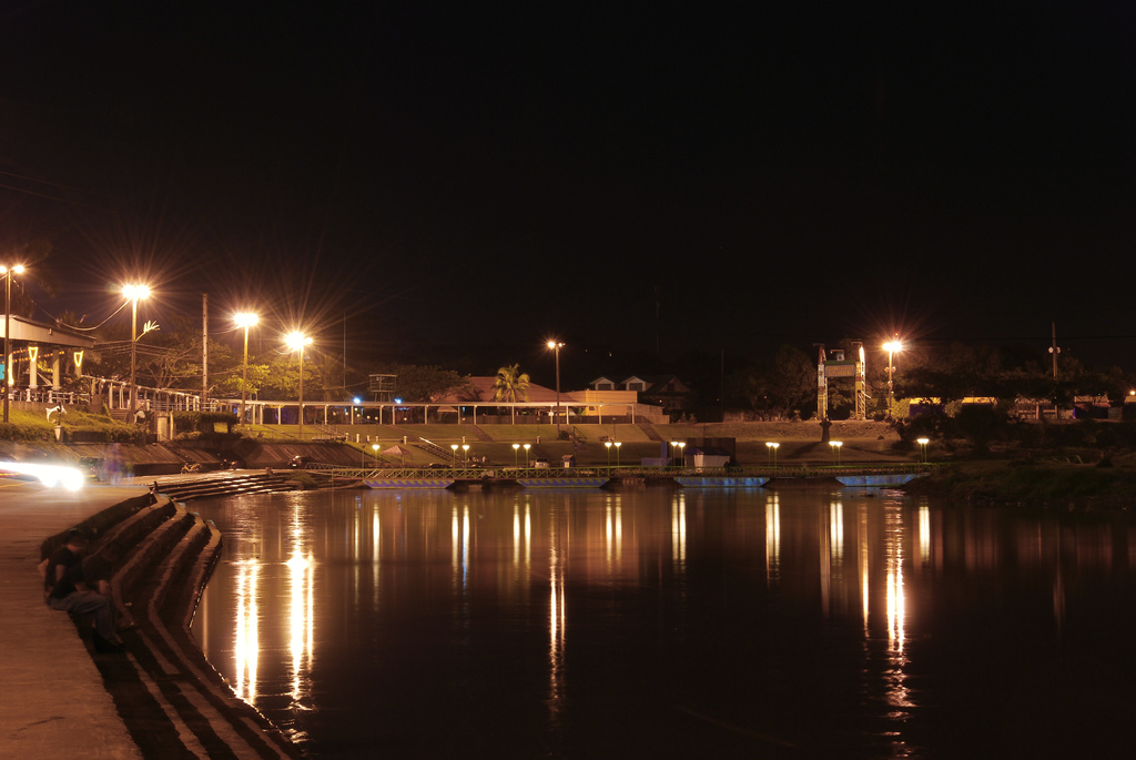
imagesize = 200px
image_caption = Marikina Riverbanks Center at night.
flag_size =
image_
seal_size = 100px
image_shield =
shield_size =
city_
citylogo_size =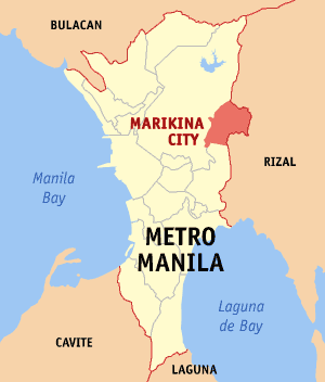
mapsize =
map_caption =Metro Manila showing the location ofMarikina City
Coordinates: 14° 38' 24" N, 121° 5' 50" E
mapsize1 =
map_caption1 =
pushpin_
pushpin_label_position =
pushpin_map_caption =
pushpin_mapsize =
subdivision_type = Country
subdivision_name =Philippines
subdivision_type1 = Region
subdivision_name1 = National Capital Region
subdivision_type2 = Districts
subdivision_name2 = 1st and 2nd Districts of Marikina
subdivision_type3 =Barangays
subdivision_name3 = 16
subdivision_type4 = Class
subdivision_name4 = 1st Class City;
Highly Urbanized
government_type =
leader_title = Mayor
leader_name =Marides Fernando
(2007-2010;Lakas-CMD /Kabayani )
leader_title1 = Vice Mayor
leader_name1 =Marion Andres
(2007-2010;Lakas-CMD /Kabayani )
leader_title2 = 1st Dist. Congressman
leader_name2 =Marcelino Teodoro
(2007-2010;Lakas-CMD /Kabayani )
leader_title3 = 2nd Dist. Congressman
leader_name3 =Del R. De Guzman
(2007-2010;Lakas-CMD /Kabayani )
established_title = Incorporated (town)
established_date =April 16 ,1630
established_title2 = Chartered city
established_date2 =December 8 ,1996
area_magnitude =
unit_pref =
area_footnotes = Hectares: 2,150
area_total_km2 = 21.50
area_land_km2 =
area_water_km2 =
area_total_sq_mi = 8.30
area_land_sq_mi =
area_water_sq_mi =
area_water_percent =
area_urban_km2 =
area_urban_sq_mi =
area_metro_km2 =
area_metro_sq_mi =
population_as_of = Dec. 2007
population_footnotes =
population_note =
population_total = 479,394
population_density_km2 = 22,297
population_density_sq_mi = 57,758
population_metro =
population_density_metro_km2 =
population_density_metro_sq_mi =
population_urban =
population_density_urban_km2 =
population_density_urban_sq_mi =
timezone = PST
utc_offset = +8
timezone_DST = Manila
utc_offset_DST =
latd= |latm= |lats= |latNS= 14°|38'|24"|N
longd= |longm= |longs= |longEW= 121°|5'|50"|E
elevation_footnotes =
elevation_m = 14.7
elevation_ft = 48.2
postal_code_type = ZIP Code
postal_code = 1800
area_code = 2
blank_name =
blank_info =
blank1_name =
blank1_info =
website = [http://city.marikina.gov.ph city.marikina.gov.ph]
footnotes = Most Competitive Metro City in the Philippines
Healthiest and Livable City in Asia-Pacific
Cleanest and Greenest City in the Philippines
The Model City of Asia
Most Discipline People in the Philippines
Pink City of HealthThe City of Marikina (Filipino: "Lungsod ng Marikina" or simply "Marikina"), known as the Shoe Capital of the Philippines, was formerly the capital of the province of
Manila during the declaration ofPhilippine Independence . Located on the island ofLuzon , Marikina City is one of the cities and a Metropolitan municipality that make up the Metropolitan Manila Area, theNational Capital Region of thePhilippines . It also belongs to Eastern Manila District of Metro Manila's 4 Districts.Marikina City is located along the eastern border of
Metro Manila ; it is bordered on the west byQuezon City , to the south byPasig City andCainta, Rizal , to the east byAntipolo City (the capital ofRizal province), and to the north by San Mateo (also inRizal ). It is approximately 21 km. away fromManila .Marikina was given the title the "Shoe Capital of the Philippines" because of its notable shoe industry. Shoemakers in the city recently finished creating the "World's Largest Pair of Shoes" and it was only recently that theGuinness Book of Records recognized this feat. The "Shoe Museum" located in the city is the home of the famous shoe collection of the former First LadyImelda Marcos , shoes of the world leaders, past presidents, famous celebrities and persons, shoes of different countries around the world etc., and contains the largest collection of pair of shoes in the world.The people of Marikina are amongst the most disciplined in the Philippines. Marikina City is considered as one of the healthiest and livable cities within the Asia-Pacific, and it is also the most industrialized and business-savvy city in Metro Manila. Marikina City is one of the wealthiest local government units (LGU) in the
Philippines in terms ofcurrent asset s, cash in banks, share of internal revenue allotment (IRA), gross income and gross net income. The city features many spacious parks, tree-lined streets, bikelanes, boulevards and commercial areas. Despite the latter, most of the city is classified as residential.Geography
Marikina City is one of the large distribution in
Metro Manila in terms of land area at approximately 21.5 square kilometers (2,150 hectares), about 3.42% of the total land area ofMetro Manila . The city lies on Marikina Valley. Not only is Marikina City a part of this valley, the valley extends to the south towardsPasig City andCainta, Rizal . Marikina River runs through the central portion of the city and Nangka River runs through the north portion. The dynamicSierra Madre Mountains, the longest mountain range in thePhilippines is located at the eastern portion while theQuezon City hills are located to the west.Marikina City is a lush
valley bounded by mountain ranges and sliced by a river. Located along the eastern border ofMetro Manila , it is bordered on the west byQuezon City , to the south byPasig City andCainta, Rizal , to the east byAntipolo City , the capital ofRizal province, and to the north by San Mateo also inRizal province. It is approximately 21 km. away fromManila and lies within coord|14|38|24|N|121|5|50|E|type:city(150000)_region:TH-30|display=inline,title.The southern portion of the city occupies the numerous commercial, industrial and business establishments and interesting places, it is also located the "center" of the city which is the busiest district of the city. While the northern portion is primarily residential areas and subdivisions, exclusive schools, industrial zones and various small and medium enterprises are also booming. Loyola Grand Villas, located at the northwest portion of the city is a rich gated community that occupies upper-middle class and rich residential area.
History
panish period
The
Augustinians were the first to arrive at the valley, at the spot now known as Chorillo, in Barangay Barangka. The Jesuits next came in 1630 in a place called Jesus Dela Pena. They established a mission and built a chapel where the first mass in Marikina was held. OnApril 16 ,1630 , Fray Pedro de Arce, apostolic ruler of the Archbishop of Manila, approved the transfer of ecclesiastical control and supervision of Marikina area to the Jesuits. The area was later called "Mariquina" in 1787 and Mariquina was declared a "pueblo" (officially town) under the Spanish colonial government.Incorporate period
Andres Bonifacio also arrived in Mariquina before he and his Katipuneros proceeded to the caves ofMontalban . Later, when thePhilippine Revolution broke out, Mariquina became the capital of the province ofManila from 1898 to 1899, a period which declare the PhilippineIndependence byEmilio Aguinaldo , the first Philippinepresident , inKawit ,Cavite . Shortly after the Americans took possession of the Philippines, its name officially became "Marikina " and the province ofRizal was created onJune 11 ,1901 by virtue of Act No. 137 by the First Philippine Commission which during the time was acting as the unicameral legislative body in the island ofLuzon . Marikina, along with many other towns aroundManila were incorporated into the new province. OnNovember 7 ,1975 , by virtue of Presidential Decree No. 824, the thirteen western towns ofRizal , including Marikina, were made part of the new Metropolitan Manila Area.Recent history
By the turn of the 20th century, Marikina had emerged as a town of shoemakers. Honed by years in shoe manufacturing, the natives had developed a work ethic that prepared them for the arrival of heavy industries in the 1950s. With the industrial plants came waves of workers who chose to stay, rapidly increasing the population. The city soon became a victim of runaway growth, resulting in the
Marikina River being polluted by the factories and squatters along the riverbanks.In 1992, the city found a new direction under the dynamic leadership of Mayor
Bayani Fernando (now, Chairman of theMetropolitan Manila Development Authority ). By dint of hard work and discipline, guided by the vision of a modern, livable city, Marikina has since been transformed into the beautiful and industrialized urban city that it is now. OnDecember 8 ,1996 , the municipality ofMarikina became a chartered city and transformed rapidly into a highly urbanized and first class city by virtue of Republic Act No. 8223, same date as the Feast of Immaculate Conception.Timeline
Landmarks and attractions
Here are some of Marikina's points of interest:
Cityhood Park
Located at the corner of Shoe Avenue and Sumulong Highway, beside Marikina Sports Park. It is the newest attraction in the city showcasing a beautiful and colorful water fountain, with benches and trees surrounding it. Cityhood Park is now a signature landmark of Marikina because it was featured in numerous television programs. Thefacade looks like a church with a giant clock on top of it and bells which rings every hour accompanied with music.Evolution Park
Where this park stands was once the only grazing farm in Marikina, in which 18 stone cows now stand, and is located in Marikina Heights.Jesus Dela Peña Chapel
The first church in Marikina. In April 1630, Fray Pedro de Arce, apostolic ruler of the Archbishopric of Manila, approved the transfer of ecclesiastical control and supervision of the Marikina area to theSociety of Jesus , and directed the Augustinians to cede the territory to the Society to be converted to ranch for the support of the Universidad Maximo de San Ignacio in Manila. The Jesuits also decided to build a mission chapel near the banks ofMarikina River , a rocky place which they called Jesus Dela Peña. Cavada also considers the year 1630, as the year the mission church was completed, and where mass was regularly held.Loyola Memorial Park
Located along A. Bonifacio Avenue, a privately-owned memorial park set on a sprawling area of 36,000 m² and developed in 1965. TheLoyola Memorial Park is the oldest, probably one of the biggest, and most prominent memorial parks in thePhilippines .Manila Boystown Complex
This government-owned institution exclusively for boys especially the street children and neglect by parents which the institution gives a traditional care and hope.Marcos Highway
was named by former Philippine presidentFerdinand Marcos , Marcos Highway is an 8-lane national highway and the main road between Metro Manila and Rizal Province, also known asMarikina-Infanta Highway . Marcos Highway passing the boundaries of Antipolo, Cainta, Pasig and Marikina. There are 3 main intersections in Marcos Highway such as Ligaya (Pasig), Tropical/Sta. Lucia (Marikina) and Masinag (Antipolo), and an interchange located in SM City Marikina which provide access exclusively between Marikina to major business districts such asOrtigas Center ,Eastwood andMakati City . Some of its landmarks include Sta. Lucia Mall, Robinsons Metro East, SM City Marikina, LRT2 Santolan Station, Masinag Market and Riverbanks Center. Also, Marcos Highway is well-known for numerous establishments like car shops, major schools, restos, food chains, exclusive villages, billboards, industrial parks and more.Marikina City Hall
Marikina City Hall is one of the most beautiful city halls inMetro Manila and it has state-of-the-art facilities inside. The city hall is surrounded by many city government agencies and offices, spacious parks, monuments and open areas, and it was located in the heart of the city. Marikina City Hall has e-government services offered for the people ofMarikina . It also has an emergency hotline, Marikina Rescue 161, which is exclusive to the residents of Marikina. Its main building is only a few steps away from the city hall.Marikina City's Largest Pair of Shoes in the World
This is certified by the Guinness Book of World Records as the world's largest pair of shoes. It is currently displayed at the Riverbanks Center and it is one of the top attractions in the city.[http://www.marikinahotel.com/ Marikina Hotel]
This is the city's first government-ownedhotel that will further boost the influx of tourists in the city, and located at SSS Village.Marikina Entertainment District
A. Tuazon Avenue's ("Gil Fernando Avenue") well-known line-up of having many adventurous bars, live acoustic bands restos, nightclubs and other drinking joints, nearly the entire stretch.Marikina Industrial Zone
Located at the northeast portion of the city which was established in the 1970s. It is home to a number of industries and some of which are the biggest and are the leaders in their fields, some of these are Purefoods-Hormel,Nestle ,Fortune Tobacco , Armscor and other leading industries and big companies.Marikina Market Mall
Metro Manila's cleanest and well-maintained market is Marikina Public Market, known as Marikina Market Mall. It is also one of the biggest market place inMetro Manila in terms of area.Marikina River Park
Most awarded river which set as theHall of Fame awardee for the Cleanest Inland Body of Water in thePhilippines . Marikina River Park is a popular camping site, picnic grounds and recreational park, such as concrete jogging and bike lanes, benches and skating rink. At night, Marikina River Park transforms into a modern nightlife events center because of numerous bars, restaurants, cafés and night clubs along the riverbanks. Other attractions in Marikina River include the Roman Garden, Chinese Pagoda, Kawayanan, Youth Camp, Animal Trail, Skating Rink and Women's Park. It is also a traditional venue for the Marikina Christmas Festival which begins annually as early as October.Marikina Sports Park
Established in 1969 and then known as the Rodriguez Sports Center, the property was bought from the provincial Government ofRizal in 1995. It is also one of the premier sports complex established in thePhilippines . It is now a popular venue for national, regional and international sports competitions and other sports and entertainment events, such as the23rd Southeast Asian Games . Inside the sports park includes the bronze statues of different Olympic sports, Olympic-size oval and swimming pool, boxing, tennis, table tennis, taekwondo, aerobics arena and others.Diocesan Shrine-Parish of Our Lady of the Abandoned
Also known as OLA Church, this Spanish-era church is located along J. P. Rizal Street in Santa Elena. The church was started by theAugustinians in 1687 and was finished in 1690. On October 21, 1791, the whole parish was consecrated under the Marian title, Nuestra Sra. Delos Desamparados (Our Lady of the Abandoned), the second oldest parish in the Philippines after that of Sta. Ana in Manila under that title This place of worship was destroyed by earthquakes and by fires in 19th century. It has undergone a series of renovations since 1963. The church houses the miraculous image of the religiouspatron of Marikina City, Our Lady of the Abandoned (OLA), which was canonically crowned lastOctober 15 ,2005 by virtue ofPope Benedict XVI , the first under his papacy. Leading the coronation rites was His Eminence, Gaudencio Cardinal Rosales of the Archdiocese of Manila. On August 5, 2007, the church was elevated into a diocesan shrine by the Most Rev. Gabriel V. Reyes, D.D., Bishop of Antipolo. Also in 2007, the parish was made the residence of the new auxiliary bishop of the Diocese of Antipolo, Most Rev. Francisco M. de Leon, D.D. who serves as its parish priest. The shrine has now become a center of pilgrimage not only for Marikina residents but also from devotees of Our Lady of the Abandoned from Metro Manila and other neighboring provinces.[http://www.science-centrum.ph/ Philippine Science Centrum]
This is thePhilippines largest and well-maintained science centrum and it is one of the most visited amenities inside Riverbanks Center especially the field trips of students came from different schools in Metro Manila.[http://www.riverbankscenter.com/ The Riverbanks Center]
Formerly Universal Textiles, Asia's largest textile mills company, located along A.Bonifacio Avenue and nearby Marcos Highway. It is now a center for shopping, commerce, business and entertainment inMarikina , and in 2008, it was declared as Metro Manila's latest developing business district. Other attractions and buildings in Riverbanks Center include Riverbanks Mall, Riverbend Hotel, RiverbanksAmphitheatre ,Gazebo , [http://www.science-centrum.ph/ Philippine Science Centrum] , Floating Stage, Open-air food stalls and Stone Carabaos. At Riverbanks Mall, here you will find almost everything you need at a price reasonably affordable, such as supermarkets, department stores, a numerous boutiques, cellphone shops, shops, food stands, fastfood chains and many more. Also, Riverbanks Center is a home of ICT Group, one of the largest IT call centers in the Philippines. SM City Marikina is also nearby within Riverbanks Center.Sentrong Pangkultura ng Marikina
This 200-year old building was once owned by Don Laureano "Kapitan Moy" Guevarra, recognized as the father of shoe industry in the Philippines. This is where the first pair of shoes in Marikina was designed and made in 1887. Inside this building can be found Doll Museum, Marikina City's museum, a dioramas showcasing the events and history of Marikina. This building is the center of culture and arts of Marikina.Shoe Museum
The Shoe Museum houses about 800 pairs of shoes belonging to formerFirst Lady Imelda Marcos . It is also a place which a record-holder as the most numerous pair of shoes in the world.SM City Marikina Teatro Marikina
This is the center of performing arts ofMarikina and easternMetro Manila . This facility also caters to various events such as plays, concerts, shows, exhibits and seminars. Teatro Marikina is also the venue of annual pre-pageant ofMiss Earth in thePhilippines , notable concerts and plays played by the biggest celebrities and artists in thePhilippines .Women's Park
Located beside Marikina River Park. It is a park dedicated and exclusive to women empowerment of Marikina established by Marikina's first woman mayor, Marides Fernando.World of Butterflies
You will find hundreds of butterflies in different variety, kind and sizes. Also, frogs, caterpillars and all animals necessary for the food chain of the butterfly is bred there. A souvenir house is also available. It's considered as thePhilippines largest collection of different butterflies and other species. Field trips and tourist are attracted to this place because of its natural ambiance especially for the nature lover.Other landmarks
Blue Wave Mall
Bayan-Bayanan Avenue
Circle Mall
Doll Museum
Loyola Grand Villas
LRT Line 2 Santolan Depot Station
Maria Quina StatueRobinsons Place Metro East
Sta. Lucia East Grandmall Complex
TESDA OfficePeople
People native to Marikina City refer to themselves as "Marikeños". Marikeños are some of the most disciplined people in the
Philippines .Fact|date=July 2008Ethnic groups
Like other places in
Metro Manila , the original settlers are Tagalogs. Throughout the centuries, there has been constant migration ofSpaniards , Visayans, Bikolanos, Ilokanos, Chinese and Americans. There are also very small migration from Indians, Koreans and Japanese.Languages
The main language is Filipino, which is based on Tagalog. In addition, due to continuous development of the city,
English language is used in education, business and information technology.Religions
Marikina was one of the seats of the Spanish colonial government in the past centuries, and has been used as the base of
Roman Catholic missions to thePhilippines . Among the religious orders include the Dominicans, theFranciscans , theJesuits , and theAugustinians which the first to arrive in Marikina. Almost 94% of Marikeño are Roman Catholic.Parish of Our Lady of the Abandoned is the seat of Nuestra Señora de los Desamparados, the
Patron Saint of Marikina City. Other notable churches in the city include Jesus Dela Peña Chapel, this first chapel established in Marikina, andImmaculate Conception Parish (ICP) in Concepcion Uno, second largest and most populated church in Marikina. Other Christian faiths like PentecostalMissionary Church of Christ, the headquarters of Church of Christ 4th Watch in thePhilippines , Iglesia ni Cristo, Philippine Independent Church (Aglipayan) and some others. Some other religions in Marikina areHinduism , [Shikhism] ,Buddhism andIslam .Government
Government
Marikina City is governed by a
Mayor andVice Mayor elected to three-year terms. The Mayor is the executive head and leads the city's departments in executing the city ordinances and improving public services while the Vice Mayor heads a legislative council. Marikina City is divided into 2 districts, Districts 1 and 2, where each districts is represented by a congressman in theHouse of Representatives of the Philippines .Marikina boasts one of the wealthiest local governments in the
Philippines in terms of current assets, cash in banks, share of internal revenue allotment, gross income and gross net income.Incumbent Mayor: Ma. Lourdes "Marides" C. Fernando
Incumbent Vice Mayor:Marion Andres , M.D.
Incumbent 1st District Congressman:Marcelino Teodoro
Incumbent 2nd District Congressman:Del R. De Guzman Public Secondary Schools
* Concepcion High School
* Concepcion Integrated High School
* Marikina Heights National High School
* Marikina High School
*Marikina Science High School (City-Owned School)
* Parang High School
* Santan High School
* Sta. Elena High School
* Tañong High School
* Nangka High SchoolPublic Tertiary Schools
* Marikina Polytechnic College
* Pamantasan ng Lungsod ng MarikinaNotable Private Elementary Schools
Notable Private Secondary Schools
* Gentle Angels School
* Infant Jesus Academy
* KOSTKA School
* MDC Christian Academy
* Marikina Christian Academy
*Marist School - Marikina
* National Christian Life College
* Our Lady of Perpetual Succor College
* Roosevelt College
* St. Scholastica's AcademyTertiary and Vocational Schools
Hospitals in Marikina
Those are major hospitals in
Marikina :Public Hospitals
* Amang Rodriguez Medical Center
* [http://www.marikinamedical.com/ Marikina Valley Medical Center]
* Marikina Diagnostic and Specialty CenterPrivate Hospitals
* Garcia General Hospital
* Immaculate Conception Hospital
* [http://www.themedicalcity.com/Site/MedicalCity/Home.aspx?SS=874/ The Medical City Marikina]
* P. Gonzales Memorial Hospital
* St. Victoria Hospital
* St. Vincent Hospital
* Sta. Monica Hospital
* SDS Medical Center Inc.Roads in Marikina
Those are some major roads in
Marikina :National Highway
* Marcos HighwayNational Roads
* A. Bonifacio Avenue
* Bayan-Bayanan Avenue
* Sumulong Highway
* J. P. Rizal Avenue
* Shoe Avenue
* Gil Fernando Avenue (Angel Tuazon Avenue)
* Fortune Avenue (C. M. Recto Street)
* E.Rodriguez Avenue
* Major Dizon Avenue
* General Ordonez Ave. (Molave Street)
* C5 Access Road
* Katipunan Street (Marikina Heights to Cainta)
* Rainbow Street
* Lilac StreetBridges
* Marikina Bridge
* Marcos Highway Bridge
* Disodado Macapagal Bridge
* Gil Fernando Bridge (Tumana Bridge)
* Nangka Bridge
* Modesta Bridge
* Balara-San Mateo Bridge
* Barangka OverpassGallery
Twin and Sister Cities
Twin Cities
* Brampton,
Ontario inCanada
*Singapore ister Cities
*flagicon|Philippines
Bacolod City ,Philippines
*flagicon|PhilippinesQuezon City ,Philippines
*flagicon|PhilippinesAntipolo City ,Philippines
*flagicon|PhilippinesMasbate City ,Philippines
*flagicon|PhilippinesPasig City ,Philippines
*flagicon|PhilippinesMuntinlupa City ,Philippines
*flagicon|PhilippinesCebu City ,Philippines
*flagicon|PhilippinesPuerto Princesa City ,Philippines
*flagicon|PhilippinesGeneral Santos City ,Philippines
*flagicon|PhilippinesDavao City ,Philippines ee also
*
Bayani Fernando
*Barangka (Marikina)
*Congressional District of Marikina
*Marikina Holy Week Procession
*Marikina River
* Metropolitan Manila Development Authority
*Our Lady of the Abandoned (OLA)
*Santolan LRT Station
*Marist School - Marikina References
Prints
* Marikina Yellow Pages Directory, "Directory Publications, Inc."
* Marikina Citizens' Factbook, Annual City Factbook
* Marikina River Digest, Official Publication of Marikina
* Balitang Komunidad, Official Newsletter of Marikina
* Marikina City Annual Report, Annual City Report Book
* WOW (World of Women) MagazineExternal links
* [http://city.marikina.gov.ph/ Official Website of the City Government of Marikina]
* [http://city.marikina.gov.ph/medialibrary/ Marikina Media Library Center]
* [http://gis.marikina.gov.ph/website/map2/viewer.htm Marikina Interactive Map Viewer]
* [http://news.marikina.gov.ph/forum/ Marikina City Community Forum]
* [http://www.marikinabiz.com/ Marikina City Business Directory]
* [http://www.marikinavalley.com/ Marikina City Community Portal]
* [http://www.marikenya.com/ Marikina City Resource Blog]
Wikimedia Foundation. 2010.