- Maryland Route 446
-
Maryland Route 446
Broad Neck Road 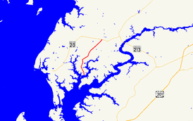
Route information Maintained by MDSHA Length: 6.03 mi[1] (9.70 km) Major junctions South end: Langford Bay Road on Broad Neck North end:  MD 20 near Chestertown
Location Counties: Kent Highway system Maryland highway system
Interstate • US • State • Minor • Former • Turnpikes←  MD 445
MD 449  →
→Maryland Route 446 (MD 446) is a state highway in the U.S. state of Maryland. Known as Broad Neck Road, the state highway runs 6.03 miles (9.70 km) from Broad Neck in southwestern Kent County north to MD 20 near Chestertown. The northern half of MD 446 was constructed around 1930. MD 446 was extended to its present southern terminus in the late 1980s.
Contents
Route description
MD 446 begins at an intersection with Langford Bay Road. Broad Neck Road continues south as a county highway to the southern end of Broad Neck.[1] MD 446 passes through a mix of farmland and forests on the Broad Neck peninsula between the East and West Forks of Langford Creek.[2] The state highway crosses Mill Pond Creek shortly before reaching its northern terminus at MD 20 (Chestertown Road) a short distance west of Chestertown.[1][2]
History
MD 446 was constructed as a state highway from MD 20 south about 3 miles (4.8 km) in 1929 and 1930.[3][4] The portion of Broad Neck Road south to Langford Bay Road remained a county highway until MD 446 was extended south to its present terminus in 1989.[5]
Junction list
The entire route is in Kent County.
Location Mile
[1]Destinations Notes Broad Neck 0.00 Broad Neck Road south / Langford Bay Road west Southern terminus Chestertown 6.03 MD 20 (Chestertown Road) – Chestertown, Rock HallNorthern terminus 1.000 mi = 1.609 km; 1.000 km = 0.621 mi References
- ^ a b c d "Highway Location Reference: Kent County" (PDF). Maryland State Highway Administration. 2009. http://www.marylandroads.com/Location/2009_KENT.pdf. Retrieved 2010-10-07.
- ^ a b Google, Inc. Google Maps – Maryland Route 446 (Map). Cartography by Google, Inc. http://maps.google.com/maps?f=d&source=s_d&saddr=MD-446+N%2FBroad+Neck+Rd&daddr=MD-446+N%2FBroad+Neck+Rd&geocode=FUZEVQId6uB1-w%3BFWxeVgId1pl2-w&hl=en&mra=ls&sll=39.139248,-76.152034&sspn=0.015212,0.038581&ie=UTF8&t=h&z=12. Retrieved 2010-06-08.
- ^ Report of the State Roads Commission of Maryland. 1927-1930. Baltimore: Maryland State Roads Commission. 1930-10-01. p. 218. http://www.archive.org/details/reportofstateroa1927mary. Retrieved 2010-10-07.
- ^ Maryland Geological Survey. Map of Maryland Showing State Road System: State Aid Roads and Improved County Road Connections (Map) (1930 ed.).
- ^ Maryland State Highway Administration. Maryland: Official Highway Map (Map) (1989 ed.).
External links
Roads in Kent County, Maryland State highways 
U.S. Highways Categories:- State highways in Maryland
- Roads in Kent County, Maryland


Wikimedia Foundation. 2010.