- Maryland Route 20
-
Maryland Route 20
Route information Maintained by MDSHA Length: 13.74 mi[1] (22.11 km) Major junctions South end: Beach Road/Lawton Avenue in Rock Hall  MD 445 in Rock Hall
 MD 288 in Rock Hall
 MD 21 near Fairlee
 MD 298 in Fairlee
 MD 446 near Chestertown
 MD 514 in Chestertown
North end:  MD 291 in Chestertown
Location Counties: Kent Highway system Maryland highway system
Interstate • US • State • Minor • Former • Turnpikes←  MD 19
MD 19MD 21 →Maryland Route 20 (MD 20) is a state highway in the U.S. state of Maryland. The state highway runs 13.74 miles (22.11 km) from Beach Road and Lawton Avenue in Rock Hall east to MD 291 in Chestertown. MD 20, which connects Chestertown with several villages in western Kent County, was designated one of the original state roads to be improved by the Maryland State Roads Commission in 1909. The first section of the highway was completed near Fairlee in 1915. The highway east to Chestertown and southwest to Rock Hall was completed in the late 1910s. MD 20 was relocated south of Fairlee in the mid 1920s, at Fairlee in the mid 1950s, and in Rock Hall in the mid 1960s. The eastern terminus was rolled back from downtown Chestertown to MD 291 in the late 1980s. Another section of MD 20 was constructed in southeastern Baltimore County between Fort Howard and Baltimore in the early 1920s. The two MD 20s were connected by a ferry across the Chesapeake Bay in the mid-1920s. The western MD 20 was bypassed by MD 151 from Edgemere to Baltimore in the early 1940s and removed from the state highway system in the late 1990s.
Contents
Route description
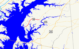
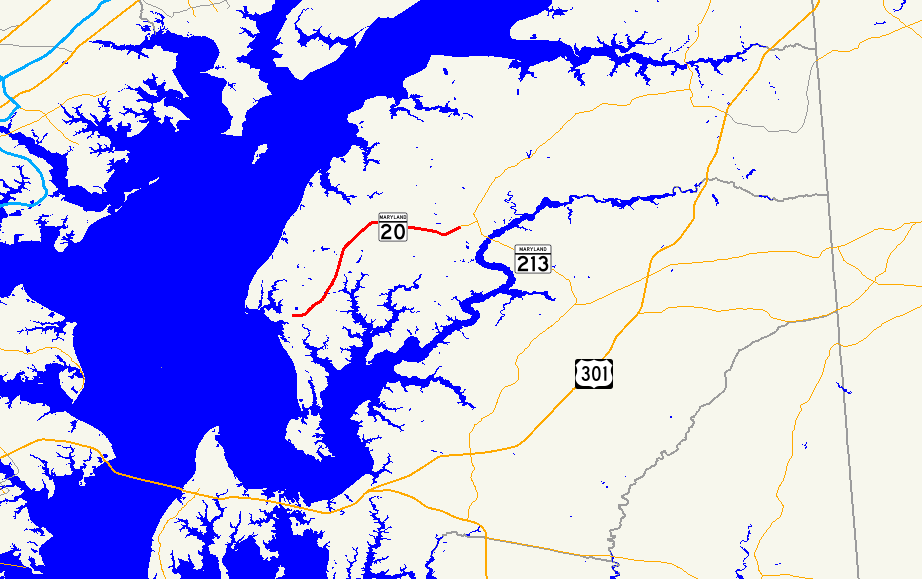
MD 20 begins at an intersection with Beach Road and Lawton Avenue in the town of Rock Hall just east of where Swan Creek empties into the Chesapeake Bay. The state highway heads east as Rock Hall Avenue, a two-lane road that passes by a few residential neighborhoods and a few marinas. In the downtown area of Rock Hall, MD 20 intersects MD 445 (Main Street) and heads through a commercial strip as a three-lane road with center turn lane. The state highway reduces to two lanes and its name changes to Rock Hall Road upon leaving the town limits, after which the highway intersects the old alignment of MD 20, MD 674 (Sharp Street) and MD 288 (Crosby Road). MD 20 curves to the northeast, passing through a mix of farmland and forest with scattered residences.[1][2]
Shortly after crossing Shipyard Creek, MD 20 intersects MD 21 (Tolchester Beach Road). The state highway meets the southern terminus of MD 298 (Fairlee Road), then curves to the east outside of the village of Fairlee. At Old Fairlee Road, the highway's name changes to Chestertown Road and the highway passes through farmland. MD 20 intersects the northern end of MD 446 (Broad Neck Road) before crossing the East Fork of Langford Creek. The state highway intersects the southern end of MD 514 (Flatland Road) before curving to the southeast, crossing Radcliffe Creek, and entering the town limits of Chestertown. Shortly thereafter, MD 20 reaches its eastern terminus at an intersection with the western terminus of MD 291 (Morgnec Road), which leads to MD 213. The roadway continues southeast as High Street toward downtown Chestertown.[1][2]
History
The Chestertown–Rock Hall highway was one of the roads designated for improvement by the Maryland State Roads Commission in 1909.[3] The highway between Fairlee and near Broad Neck Road was paved in 1915.[4] The gap between Broad Neck Road and Chestertown, including High Street within the town, was constructed in 1917 and 1918. The segment from Fairlee to Shipyard Creek was built in 1918.[5] The remainder of the highway from Shipyard Creek through Rock Hall to Gratitude was completed between 1919 and 1921.[5][6]
The first major realignment of MD 20 occurred between Fairlee and Shipyard Creek. A straight alignment was constructed between MD 21 and Shipyard Creek, bypassing Sandy Bottom Road and Ricauds Branch Road, by 1927. Also in 1927, MD 20 became one of the original state-numbered highways.[7] The state highway was widened from Chestertown to Rock Hall in 1948 and from Rock Hall to the western terminus in 1954.[8][9] A new alignment of MD 20 was constructed to the east of Fairlee around 1955.[9][10] The state highway originally followed Sharp Street and Main Street west to the intersection of Main Street and Rock Hall Avenue in Rock Hall. MD 20 was moved to an eastward extension of Rock Hall Avenue, bypassing the center of Rock Hall, in 1967.[11] MD 20's eastern terminus in downtown Chestertown was retracted to College Avenue in 1985 and to its present terminus at MD 291 in 1989.[12][13]
MD 20 was also assigned to North Point Road in southeastern Baltimore County as one of the original state-numbered highways in 1927.[7] The state highway was constructed from Edgemere to the community of North Point in Dundalk by 1921.[6] MD 20 was extended north to US 40 in Baltimore and south toward Fort Howard in 1923.[14] The state highway's southern terminus was at the intersection of North Point Road with an interurban that connected Baltimore with Bay Shore Amusement Park, a summer resort that operated between 1906 and 1947 within what is now North Point State Park.[14][15] Between 1923 and 1927, a ferry operated between the amusement park and Rock Hall that briefly indirectly connected the two MD 20s.[14][7] The portion of MD 20 from Edgemere to Baltimore was bypassed by MD 151 between 1940 and 1944; MD 151 was extended north from Edgemere as a four-lane divided highway as a defense access project to better connect Baltimore with the Bethlehem Steel complex at Sparrows Point.[16][17][18] The remaining disjoint sections of MD 20 between Fort Howard and Baltimore were removed from the state highway system by 1999.[19]
Junction list
The entire route is in Kent County.
Location Mile[1] Destinations Notes Rock Hall 0.00 Beach Road south / Lawton Avenue north Western terminus 1.38 MD 445 (Main Street) – Tolchester Beach, Eastern Neck Island1.88  MD 674 west (Sharp Street)
2.03 MD 288 east (Crosby Road)Fairlee 6.60 MD 21 west (Tolchester Beach Road) – Tolchester Beach7.93 MD 298 east (Fairlee Road) – Still Pond, Galena11.60 MD 446 south (Broad Neck Road)Chestertown 13.55 MD 514 north (Flatland Road)13.74  MD 291 east (Morgnec Road) to MD 213 / High Street south – Millington, Galena, Church Hill
Eastern terminus 1.000 mi = 1.609 km; 1.000 km = 0.621 mi References
- ^ a b c d "Highway Location Reference: Kent County" (PDF). Maryland State Highway Administration. 2009. http://www.marylandroads.com/Location/2009_KENT.pdf. Retrieved 2010-10-07.
- ^ a b Google, Inc. Google Maps – Maryland Route 20 (Map). Cartography by Google, Inc. http://maps.google.com/maps?f=d&source=s_d&saddr=Rock+Hall+Ave&daddr=High+St&geocode=FRo-VQIdul10-w%3BFdJtVgId1x93-w&hl=en&mra=ls&sll=39.213536,-76.071782&sspn=0.015262,0.038581&ie=UTF8&t=h&z=12. Retrieved 2010-10-07.
- ^ Maryland Geological Survey. Map of Maryland (Map) (1910 ed.).
- ^ Report of the State Roads Commission of Maryland (1912–1915 ed.). Baltimore: Maryland State Roads Commission. May 1915. p. 112. http://www.archive.org/details/annualreportsofs1912mary. Retrieved 2010-10-07.
- ^ a b Report of the State Roads Commission of Maryland (1916–1919 ed.). Baltimore: Maryland State Roads Commission. January 1920. p. 46. http://www.archive.org/details/annualreportsofs1916mary. Retrieved 2010-10-07.
- ^ a b Maryland Geological Survey. Map of Maryland: Showing State Road System and State Aid Roads (Map) (1921 ed.).
- ^ a b c Maryland Geological Survey. Map of Maryland: Showing State Road System and State Aid Roads (Map) (1927 ed.).
- ^ Report of the State Roads Commission of Maryland (1947–1948 ed.). Baltimore: Maryland State Roads Commission. 1949-02-15. p. 106. http://www.archive.org/details/reportofstateroa1947mary. Retrieved 2010-10-07.
- ^ a b Report of the State Roads Commission of Maryland (1953–1954 ed.). Baltimore: Maryland State Roads Commission. 1954-11-12. pp. 150, 152. http://www.archive.org/details/reportofstateroa1953mary. Retrieved 2010-10-07.
- ^ Maryland State Roads Commission. Maryland: Official Highway Map (Map) (1956 ed.).
- ^ Maryland State Roads Commission. Maryland: Official Highway Map (Map) (1967 ed.).
- ^ Maryland State Highway Administration. Maryland: Official Highway Map (Map) (1985-86 ed.).
- ^ Maryland State Highway Administration. Maryland: Official Highway Map (Map) (1989 ed.).
- ^ a b c Maryland Geological Survey. Map of Maryland: Showing State Road System and State Aid Roads (Map) (1923 ed.).
- ^ "North Point State Park". Maryland Department of Natural Resources. http://www.dnr.state.md.us/publiclands/central/northpoint.asp. Retrieved 2011-05-23.
- ^ Report of the State Roads Commission of Maryland (1939–1940 ed.). Baltimore: Maryland State Roads Commission. 1941-03-15. p. 103. http://www.archive.org/details/reportofstateroa1939mary. Retrieved 2011-05-23.
- ^ Report of the State Roads Commission of Maryland (1943–1944 ed.). Baltimore: Maryland State Roads Commission. 1945-03-01. p. 89. http://www.archive.org/details/reportofstateroa1943mary. Retrieved 2011-05-23.
- ^ Maryland State Roads Commission. Maryland: Official Highway Map (Map) (1946-47 ed.).
- ^ Maryland State Highway Administration. Maryland: Official Highway Map (Map) (1999-2000 ed.).
External links
Roads in Kent County, Maryland State highways 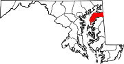
U.S. Highways Categories:- State highways in Maryland
- Roads in Kent County, Maryland


Wikimedia Foundation. 2010.