- Maryland Route 445
-
Maryland Route 445
Route information Maintained by MDSHA Length: 11.96 mi[1] (19.25 km) Major junctions South end: End of state maintenance at Eastern Neck Island  MD 20 in Rock Hall
North end:  MD 21 in Tolchester Beach
Location Counties: Kent Highway system Maryland highway system
Interstate • US • State • Minor • Former • Turnpikes←  MD 444
MD 446  →
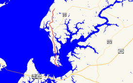
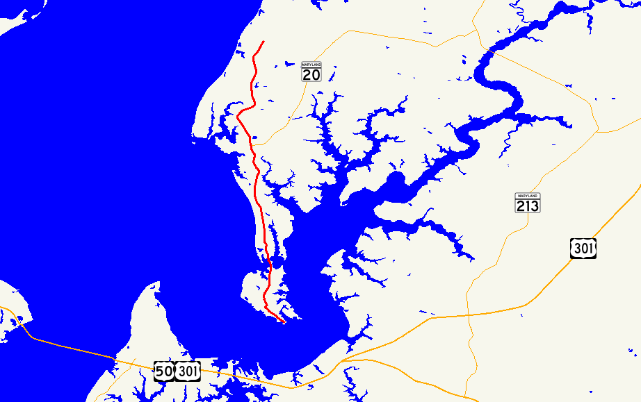
→Maryland Route 445 (MD 445) is a state highway in the U.S. state of Maryland. The state highway runs 11.96 miles (19.25 km) from Eastern Neck Island in the southwest corner of Kent County north to MD 21 in Tolchester Beach. MD 445 connects Rock Hall with the Tolchester Beach area as well as Eastern Neck National Wildlife Refuge. The state highway was constructed around 1930.
Contents
Route description
MD 445 begins at the north end of the bridge from the mainland to Eastern Neck Island.[1] Eastern Neck Road continues south toward Eastern Neck National Wildlife Refuge.[2] MD 445 heads north through farmland until the highway enters the town of Rock Hall immediately after passing Boundary Street.[1][2] The state highway is known as Main Street through Rock Hall, where the highway intersects Sharp Street and MD 20 (Rock Hall Avenue). After passing Rock Hall Ball Park, MD 445 leaves the town limits and its name changes to Tolchester Road.[1] The state highway passes through a mix of farms and forests and crosses Swan Creek before reaching its northern terminus at Tolchester Beach Road.[1][2] Tolchester Beach Road is marked as MD 21 east from the intersection and is a county highway west to the old beach resort, while the roadway continues north as Bay Shore Road.[2]
History
MD 445 was constructed from Tolchester Beach south through Rock Hall to approximately 1 mile (1.6 km) north of Eastern Neck Island in 1929 and 1930.[3][4] The remainder of the highway to the north end of the bridge to the island was completed shortly after 1930.[3][5]
Junction list
The entire route is in Kent County.
Location Mile
[1]Destinations Notes Eastern Neck Island 0.00 Eastern Neck Road south – Eastern Neck National Wildlife Refuge Southern terminus Rock Hall 5.87 Sharp Street Old alignment of MD 20 6.01 MD 20 (Rock Hall Avenue) – ChestertownTolchester Beach 11.96 MD 21 east (Tolchester Beach Road) / Tolchester Beach Road west / Bay Shore Road northNorthern terminus 1.000 mi = 1.609 km; 1.000 km = 0.621 mi References
- ^ a b c d e f "Highway Location Reference: Kent County" (PDF). Maryland State Highway Administration. 2009. http://www.marylandroads.com/Location/2009_KENT.pdf. Retrieved 2010-10-07.
- ^ a b c d Google, Inc. Google Maps – Maryland Route 445 (Map). Cartography by Google, Inc. http://maps.google.com/maps?f=d&source=s_d&saddr=MD-445+N%2FEastern+Neck+Island+Rd&daddr=MD-445+N%2FTolchester+Rd&geocode=FerwUwIdiPF0-w%3BFY5fVgIdduJ0-w&hl=en&mra=ls&sll=39.211108,-76.222072&sspn=0.015263,0.038581&ie=UTF8&t=h&z=11. Retrieved 2010-10-07.
- ^ a b Report of the State Roads Commission of Maryland. 1927-1930. Baltimore: Maryland State Roads Commission. 1930-10-01. pp. 89. 218–219. http://www.archive.org/details/reportofstateroa1927mary. Retrieved 2010-10-07.
- ^ Maryland Geological Survey. Map of Maryland Showing State Road System: State Aid Roads and Improved County Road Connections (Map) (1930 ed.).
- ^ Maryland Geological Survey. Map of Maryland Showing State Road System: State Aid Roads and Improved County Road Connections (Map) (1933 ed.).
External links
Roads in Kent County, Maryland State highways 
U.S. Highways Categories:- State highways in Maryland
- Roads in Kent County, Maryland


Wikimedia Foundation. 2010.