- Maryland Route 444
-
Maryland Route 444

Route information Maintained by MDSHA Length: 7.29 mi[1] (11.73 km) Major junctions South end:  MD 290 in Chesterville
 MD 213 in Locust Grove
North end: Belchester Road in Kentmore Park Location Counties: Kent Highway system Maryland highway system
Interstate • US • State • Minor • Former • Turnpikes←  MD 443
MD 445  →
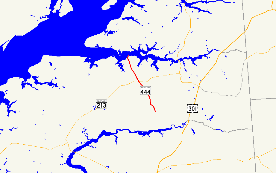
→Maryland Route 444 (MD 444) is a state highway in the U.S. state of Maryland. The state highway runs 7.29 miles (11.73 km) from MD 290 in Chesterville north to the end of state maintenance in Kentmore Park. MD 444 connects Chesterville and Kentmore Park with Locust Grove on MD 213. The state highway was constructed in the early 1930s from Locust Grove south to a railroad crossing. MD 444 was extended north to Kentmore Park in the late 1930s. MD 444 reached its present length when it was extended south to Chesterville in the mid 1990s.
Contents
Route description
MD 444 begins at an intersection with MD 290 (Chesterville Road) in Chesterville. The roadway continues east on the other side of MD 290 as county-maintained Chesterville Bridge Road. MD 444, which is named Locust Grove Road, heads west to an intersection with Morgnec Road where the state highway turns north.[1][2] The state highway passes through farmland and crosses the Chestertown Branch of the Northern Line of the Maryland and Delaware Railroad at grade before reaching MD 213 in Locust Grove.[2] MD 444 continues north as Kentmore Park Road. The state highway intersects Shallcross Wharf Road, part of which is unsigned MD 449, and Old Locust Grove Road.[1] MD 444 continues north through farmland until the road reaches the small beach community of Kentmore Park on the Sassafras River.[2] The state highway reaches its northern terminus at the end of state maintenance just north of Riverside Avenue. The roadway continues north as county-maintained Belchester Road.[1][2]
History
MD 444 was paved from U.S. Route 213 (now MD 213) at Locust Grove south to the railroad crossing by 1933.[3] In 1939, MD 444 was extended north to its present northern terminus at Kentmore Park. The highway followed Shallcross Wharf Road northeast to the center of Locust Grove, then northwest on what is now Old Locust Grove Road to its present alignment.[4] The road from the railroad crossing south to Chesterville was constructed as a county highway around 1948.[5] MD 444 between MD 213 and the railroad crossing was returned to Kent County in 1989, the same year MD 444 was moved to a new alignment bypassing Locust Grove.[6] MD 444 was redesignated south of MD 213 to the railroad crossing and south from there to its present southern terminus in Chesterville in 1995.[7]
Junction list
The entire route is in Kent County.
Location Mile
[1]Destinations Notes Chesterville 0.00 Chesterville Bridge Road east Southern terminus MD 290 (Chesterville Road) – Crumpton, Galena0.30 Morgnec Road west Former MD 447 Locust Grove 4.20 MD 213 (Augustine Herman Highway) – Chestertown, Galena4.29  MD 449 west (Shallcross Wharf Road) / Shallcross Wharf Road east
MD 449 is unsigned; old alignment of MD 444 4.63 Old Locust Grove Road east Old alignment of MD 444 Kentmore Park 7.29 Belchester Road north Northern terminus 1.000 mi = 1.609 km; 1.000 km = 0.621 mi References
- ^ a b c d e "Highway Location Reference: Kent County" (PDF). Maryland State Highway Administration. 2009. http://www.marylandroads.com/Location/2009_KENT.pdf. Retrieved 2010-10-11.
- ^ a b c d Google, Inc. Google Maps – Maryland Route 444 (Map). Cartography by Google, Inc. http://maps.google.com/maps?f=d&source=s_d&saddr=MD-444+N%2FMorgnec+Rd&daddr=MD-444+N%2FKentmore+Park+Rd&geocode=FYpOVwIdSqB5-w%3BFSK3WAIdfNJ4-w&hl=en&mra=ls&sll=39.367317,-75.962219&sspn=0.007581,0.01929&ie=UTF8&t=h&z=12. Retrieved 2010-06-08.
- ^ Maryland Geological Survey. Map of Maryland Showing State Road System: State Aid Roads and Improved County Road Connections (Map) (1933 ed.).
- ^ Maryland State Roads Commission. General Highway Map: State of Maryland (Map) (1939 ed.).
- ^ Maryland State Roads Commission. Maryland: Official Highway Map (Map) (1948 ed.).
- ^ Maryland State Highway Administration. Maryland: Official Highway Map (Map) (1989 ed.).
- ^ Maryland State Highway Administration. Maryland: Official Highway Map (Map) (1995 ed.).
External links
Roads in Kent County, Maryland State highways 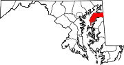
U.S. Highways Categories:- State highways in Maryland
- Roads in Kent County, Maryland


Wikimedia Foundation. 2010.