- Maryland Route 310
-
Maryland Route 310
Cayots Corner Road 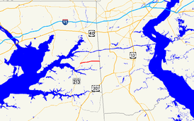
Route information Maintained by MDSHA Length: 3.96 mi[1] (6.37 km) Major junctions West end:  MD 213 in Cayots
 MD 342 in St. Augustine
East end: Churchtown Road at the Delaware state line Location Counties: Cecil Highway system Maryland highway system
Interstate • US • State • Minor • Former • Turnpikes←  MD 309
MD 311  →
→Maryland Route 310 (MD 310) is a state highway in the U.S. state of Maryland. Known as Cayots Corner Road, the state highway runs 3.96 miles (6.37 km) from MD 213 in Cayots east to the Delaware state line east of St. Augustine, where the highway continues as Churchtown Road, in southern Cecil County. MD 310 was built east of St. Augustine by 1921 and west to what was then U.S. Route 213 (US 213) by 1939. Cayots Corner was the sharp turn on US 213 at its intersection with MD 310 before US 213 was relocated to eliminate the turn in the mid 1950s.
Contents
Route description
MD 310 begins at an intersection with MD 213 (Augustine Herman Highway) in the hamlet of Cayots. Town Point Road heads west from the junction as a county highway. MD 310 heads east as a two-lane road past a spur road that is the old alignment of MD 213 at the highway's namesake corner. The state highway passes through farmland, intersecting MD 342 (St. Augustine Road) in the community of St. Augustine. MD 310 reaches its eastern terminus just east of Old Telegraph Road at the Delaware state line. The highway continues east as Churchtown Road.[1][2]
History
MD 310 was paved east of St. Augustine Road as a state-aid road by 1915.[3][4] The section west to US 213 was completed by 1939.[5] Cayots Corner was a right-angle turn for US 213 where the federal highway originally intersected MD 310.[6] That turn and a sharp turn at Town Point Road just to the west were bypassed when US 213 was moved to a new alignment to the north and west around 1956. MD 310 was then extended to its present western terminus.[7]
Junction list
The entire route is in Cecil County.
Location Mile[1] Destinations Notes Cayots 0.00 MD 213 (Augustine Herman Highway) – Cecilton, Chesapeake CityWestern terminus St. Augustine 2.16 MD 342 north (St. Augustine Road) – Chesapeake City3.96 Churchtown Road east Eastern terminus; Delaware state line 1.000 mi = 1.609 km; 1.000 km = 0.621 mi References
- ^ a b c "Highway Location Reference: Cecil County" (PDF). Maryland State Highway Administration. 2009. http://www.marylandroads.com/Location/2009_CECIL.pdf. Retrieved 2010-10-13.
- ^ Google, Inc. Google Maps – Maryland Route 310 (Map). Cartography by Google, Inc. http://maps.google.com/maps?f=d&source=s_d&saddr=MD-213+N%2FAugustine+Herman+Hwy&daddr=Cayots+Corner+Rd&hl=en&geocode=FWaDWgIdXKZ6-w%3BFdqiWgId2797-w&mra=ls&sll=39.49351,-75.781159&sspn=0.0076,0.01929&ie=UTF8&t=h&z=14. Retrieved 2010-10-13.
- ^ Report of the State Roads Commission of Maryland. 1912-1915. Baltimore: Maryland State Roads Commission. May 1915. p. 124. http://www.archive.org/details/annualreportsofs1912mary. Retrieved 2010-10-13.
- ^ Maryland Geological Survey. Map of Maryland: Showing State Road System and State Aid Roads (Map) (1921 ed.).
- ^ Maryland State Roads Commission. General Highway Map: State of Maryland (Map) (1939 ed.).
- ^ United States Geological Survey. Cecilton, MD quadrangle (Map). 1:48,000. 15 Minute Series (Topographic) (1951 ed.). http://historical.mytopo.com/quad.cfm?quadname=Cecilton&state=MD&series=15. Retrieved 2010-10-13.
- ^ Maryland State Roads Commission. Maryland: Official Highway Map (Map) (1956 ed.).
External links
Roads in Cecil County, Maryland State highways 
U.S. Highways Interstate Highways Categories:- State highways in Maryland
- Roads in Cecil County, Maryland


Wikimedia Foundation. 2010.