- Maryland Route 316
-
Maryland Route 316
Appleton Road 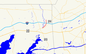
Route information Maintained by MDSHA Length: 2.67 mi[1] (4.30 km) Major junctions South end:  MD 279 in Elkton
North end:  MD 277 in Elk Mills
Location Counties: Cecil Highway system Maryland highway system
Interstate • US • State • Minor • Former • Turnpikes←  MD 315
MD 317  →
→Maryland Route 316 (MD 316) is a state highway in the U.S. state of Maryland. Known as Appleton Road, the state highway runs 2.67 miles (4.30 km) from MD 279 in Elkton north to MD 277 in Elk Mills in northeastern Cecil County. MD 316 was constructed in two sections in the early 1910s from Elkton to Elk Mills and in early 1920s north of Elk Mills. The state highway was extended south to its present terminus when MD 279 moved to a new alignment north of Elkton in the early 1960s. The northern terminus was moved south to MD 277 in the late 1960s.
Contents
Route description
MD 316 begins at an intersection with MD 279 (Elkton Road) in Elkton just north of MD 279's crossing of Big Elk Creek. The state highway heads northeast past scattered residences and Gilpin Manor Memorial Park and twice crosses a tributary of Big Elk Creek. MD 316 intersects Belle Hill Road as the highway ascends onto a ridge separating Big Elk Creek from the Christina River, which are parts of the Chesapeake Bay and Delaware Bay drainage basins, respectively. The state highway crosses Interstate 95 (I-95) with no access and passes between a distribution facility and a quarry before reaching its northern terminus in Elk Mills at MD 277, which heads west as Elk Mills Road and east as Fletchwood Road. Appleton Road continues north along the ridge as a county highway.[1][2]
History
MD 316 was paved as a state-aid road known as Barksdale Road from the northern limit of Elkton to MD 277 by 1915.[3] Another section of highway known as Cowentown Road was planned to begin construction in 1917, but it was cancelled due to World War I.[4] That disjoint portion of MD 316 was constructed from just south of the Baltimore and Ohio Railroad (now CSX) north to Barksdale Road, including a bridge over the railroad tracks, by 1923.[5][6] What is now MD 316 south of Belle Hill Road was originally MD 279, which followed Belle Hill Road northeast to its present alignment.[7] The segment of county highway from MD 277 to near the B&O crossing was brought under state maintenance around 1950 to connect the two sections of state highway.[8] In 1963, MD 316 was extended south it its present terminus when MD 279 was moved to a new alignment between Big Elk Creek and I-95.[9] MD 316's northern terminus was rolled back to MD 277 in 1968.[10]
Junction list
The entire route is in Cecil County.
Location Mile[1] Destinations Notes Elkton 0.00 MD 279 (Elkton Road)Southern terminus 1.06 Belle Hill Road Old alignment of MD 279 Elk Mills 2.67 MD 277 (Elk Mills Road/Fletchwood Road)Northern terminus Appleton Road north 1.000 mi = 1.609 km; 1.000 km = 0.621 mi References
- ^ a b c "Highway Location Reference: Cecil County" (PDF). Maryland State Highway Administration. 2009. http://www.marylandroads.com/Location/2009_CECIL.pdf. Retrieved 2010-10-14.
- ^ Google, Inc. Google Maps – Maryland Route 316 (Map). Cartography by Google, Inc. http://maps.google.com/maps?f=d&source=s_d&saddr=MD-316+N%2FAppleton+Rd&daddr=MD-316+N%2FAppleton+Rd&geocode=Fa6TXAIdIPZ6-w%3BFTAbXQId7ix7-w&hl=en&mra=ls&sll=39.637489,-75.812058&sspn=0.015169,0.038581&ie=UTF8&t=h&z=13. Retrieved 2010-10-14.
- ^ Report of the State Roads Commission of Maryland. 1912-1915. Baltimore: Maryland State Roads Commission. May 1915. p. 124. http://www.archive.org/details/annualreportsofs1912mary. Retrieved 2010-10-14.
- ^ Report of the State Roads Commission of Maryland. 1916-1919. Baltimore: Maryland State Roads Commission. January 1920. p. 44. http://www.archive.org/details/annualreportsofs1916mary. Retrieved 2010-10-14.
- ^ Maryland Geological Survey. Map of Maryland: Showing State Road System and State Aid Roads (Map) (1923 ed.).
- ^ "NBI Structure Number: 200000CE0109010". National Bridge Inventory. http://nationalbridges.com/nbi_record.php?StateCode=24&struct=200000CE0109010. Retrieved 2010-10-14.
- ^ United States Geological Survey. Elkton, MD quadrangle (Map). 1:48,000. 15 Minute Series (Topographic) (1942 ed.). http://historical.mytopo.com/quad.cfm?quadname=Elkton&state=MD&series=15. Retrieved 2010-10-14.
- ^ Maryland State Roads Commission. Maryland: Official Highway Map (Map) (1950 ed.).
- ^ Maryland State Roads Commission. Maryland: Official Highway Map (Map) (1963 ed.).
- ^ Maryland State Roads Commission. Maryland: Official Highway Map (Map) (1968 ed.).
External links
Roads in Cecil County, Maryland State highways 
U.S. Highways Interstate Highways Categories:- State highways in Maryland
- Roads in Cecil County, Maryland


Wikimedia Foundation. 2010.