- Maryland Route 342
-
Maryland Route 342
St. Augustine Road 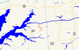
Route information Maintained by MDSHA Length: 2.82 mi[1] (4.54 km) Major junctions South end:  MD 310 in St. Augustine
North end:  MD 537 in Chesapeake City
Location Counties: Cecil Highway system Maryland highway system
Interstate • US • State • Minor • Former • Turnpikes←  MD 341
MD 343  →
→Maryland Route 342 (MD 342) is a state highway in the U.S. state of Maryland. Known as St. Augustine Road, the state highway runs 2.82 miles (4.54 km) from MD 310 in St. Augustine north to George Street, which is one of the segments of unsigned Maryland Route 537, in Chesapeake City in southern Cecil County. MD 342 was constructed in its entirety by 1915.
Contents
Route description
MD 342 begins at an intersection with MD 310 (Cayots Corner Road) in St. Augustine. The state highway heads northeast as a narrow two-lane road through farmland. MD 342 makes a right-angle turn to the northwest, curves to the west, then takes a sharp to the north through a forested area and scattered residences. Just east of the southern end of the Chesapeake City Bridge, the state highway enters the town of Chesapeake City and intersects an unnamed road (unsigned MD 537D) that leads to ramps to MD 213 (Augustine Herman Highway). MD 342 continues a short distance to its northern terminus at an oblique junction with George Street, which is unsigned MD 537C and leads to MD 286 in the South Chesapeake City Historic District.[1][2]
History
MD 342 was paved from George Street to just south of the right-angle turn by 1910.[3] The remainder of the road to St. Augustine and MD 310 east of St. Augustine were built as a state-aid road by 1915.[4][5] MD 342 has changed very little since then.
Junction list
The entire route is in Cecil County.
Location Mile[1] Destinations Notes St. Augustine 0.00 MD 310 (Cayots Corner Road)Southern terminus Chesapeake City 2.74 To  MD 213 – Elkton, Cecilton
Unsigned MD 537D 2.82 George Street to  MD 286
Northern terminus; unsigned MD 537C 1.000 mi = 1.609 km; 1.000 km = 0.621 mi References
- ^ a b c "Highway Location Reference: Cecil County" (PDF). Maryland State Highway Administration. 2009. http://www.marylandroads.com/Location/2009_CECIL.pdf. Retrieved 2010-10-13.
- ^ Google, Inc. Google Maps – Maryland Route 342 (Map). Cartography by Google, Inc. http://maps.google.com/maps?f=d&source=s_d&saddr=Cayots+Corner+Rd&daddr=N+St+Augustine+Rd&hl=en&geocode=FZKiWgIdTD17-w%3BFcMZWwIdbyR7-w&mra=ls&sll=39.522697,-75.815299&sspn=0.007664,0.01929&ie=UTF8&ll=39.50967,-75.807467&spn=0.030395,0.077162&t=h&z=14. Retrieved 2010-10-13.
- ^ Maryland Geological Survey. Map of Maryland (Map) (1910 ed.).
- ^ Report of the State Roads Commission of Maryland. 1912-1915. Baltimore: Maryland State Roads Commission. May 1915. p. 124. http://www.archive.org/details/annualreportsofs1912mary. Retrieved 2010-10-13.
- ^ Maryland Geological Survey. Map of Maryland: Showing State Road System and State Aid Roads (Map) (1921 ed.).
External links
Roads in Cecil County, Maryland State highways 
U.S. Highways Interstate Highways Categories:- State highways in Maryland
- Roads in Cecil County, Maryland


Wikimedia Foundation. 2010.