- Maryland Route 824
-
Maryland Route 824
Blythedale Road 
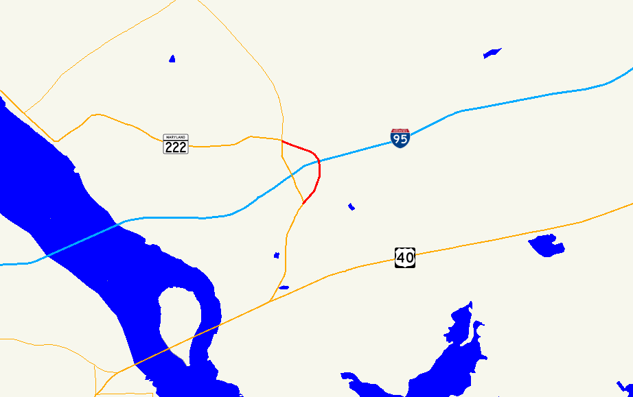
Route information Maintained by MDSHA Length: 1.06 mi[1] (1.71 km) Major junctions South end:  MD 222 in Perryville
North end:  MD 222 / MD 275 in Perryville
Location Counties: Cecil Highway system Maryland highway system
Interstate • US • State • Minor • Former • Turnpikes←  MD 822
MD 831  →
→Maryland Route 824 (MD 824) is a state highway in the U.S. state of Maryland. Known as Blythedale Road, the state highway runs 1.06 miles (1.71 km) from MD 222 north to MD 222 and MD 275 within Perryville in southwestern Cecil County. MD 824 is the old alignment of U.S. Route 222, which is now MD 222 in Perryville. MD 824 was designated on the old road after US 222 was realigned for its interchange with Interstate 95 (I-95) in the early 1960s.
Contents
Route description
MD 824 begins at an intersection with MD 222 (Perryville Road) and the entrance to Perryville Outlet Center between downtown Perryville and MD 222's interchange with I-95 (John F. Kennedy Memorial Highway). The state highway starts east as Reservoir Road but immediately turns north along two-lane Blythedale Road through a forested area with scattered residences. After passing under I-95 and intersecting Principio Road, MD 824 curves to the west toward its northern terminus at a four-way intersection with MD 222 and MD 275. MD 222 heads south toward the I-95 interchange as Perryville Road and west as Bainbridge Road toward Port Deposit, while MD 275 heads north as Perrylawn Drive toward Rising Sun.[1][2]
History
MD 824 is the old alignment of US 222 (now MD 222).[3] Blythedale Road was paved by 1921.[4] MD 824 was assigned to Blythedale Road after MD 222 was moved to its present alignment for its interchange with I-95 in 1963.[5][6]
Junction list
The entire route is in Perryville in Cecil County.
Mile[1] Destinations Notes 0.00 MD 222 (Perryville Road)Southern terminus 1.06 


 MD 222 (Bainbridge Road/Perryville Road) / MD 275 north (Perrylawn Drive) / MD 222 Truck north to US 1 – Port Deposit, Rising Sun
Northern terminus 1.000 mi = 1.609 km; 1.000 km = 0.621 mi References
- ^ a b c "Highway Location Reference: Cecil County" (PDF). Maryland State Highway Administration. 2009. http://www.marylandroads.com/Location/2009_CECIL.pdf. Retrieved 2010-10-19.
- ^ Google, Inc. Google Maps – Maryland Route 824 (Map). Cartography by Google, Inc. http://maps.google.com/maps?f=d&source=s_d&saddr=Heather+Ln&daddr=MD-222+N%2FMD-824+N%2FBlythedale+Rd+to:MD-275+N%2FPerrylawn+Dr&hl=en&geocode=FUARXAIdsFp3-w%3BFfsmXAIddmd3-w%3BFeg9XAIdWk13-w&mra=ls&sll=39.587467,-76.065989&sspn=0.003795,0.009645&ie=UTF8&t=h&z=15. Retrieved 2010-10-19.
- ^ Maryland State Roads Commission. General Highway Map: State of Maryland (Map) (1939 ed.).
- ^ Maryland Geological Survey. Map of Maryland: Showing State Road System and State Aid Roads (Map) (1921 ed.).
- ^ "NBI Structure Number: 300000CEX934010". National Bridge Inventory. http://nationalbridges.com/nbi_record.php?StateCode=24&struct=300000CEX934010. Retrieved 2010-10-19.
- ^ Maryland State Roads Commission. Maryland: Official Highway Map (Map) (1964 ed.).
External links
Roads in Cecil County, Maryland State highways 
U.S. Highways Interstate Highways Categories:- State highways in Maryland
- Roads in Cecil County, Maryland


Wikimedia Foundation. 2010.