- Maryland Route 273
-
Maryland Route 273
Route information Maintained by MDSHA Length: 16.58 mi[1] (26.68 km) Major junctions West end:  US 1 west of Rising Sun
 MD 276 in Rising Sun
 MD 274 in Rising Sun
 MD 272 in Calvert
 MD 213 in Fair Hill
East end:  DE 273 near Appleton
Location Counties: Cecil Highway system Maryland highway system
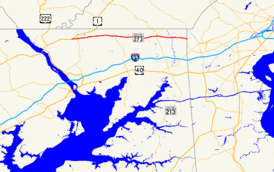
Interstate • US • State • Minor • Former • Turnpikes← MD 272MD 274 →Maryland Route 273 (MD 273) is a state highway in the U.S. state of Maryland. The state highway runs 16.58 miles (26.68 km) from U.S. Route 1 (US 1) west of Rising Sun east to the Delaware state line near Appleton, where the highway continues east as Delaware Route 273 (DE 273). MD 273 is the main east–west highway of northern Cecil County, connecting Conowingo (via US 1), Port Deposit (via MD 276, and Rising Sun with Newark, Delaware via the communities of Calvert and Fair Hill, where the highway intersects MD 272 and MD 213, respectively. The state highway also provides access to Fair Hill Natural Resources Management Area. MD 273 contains a section of MD 274 Truck between MD 274 in Rising Sun and MD 272 in Calvert.
MD 273 west of Fair Hill was constructed as one of the original state roads, with the portion west of the intersection of Sylmar Road east of Rising Sun constructed as part of US 1 in the 1910s. The first sections of MD 273 proper were paved in the early 1910s west of Calvert. The final section of the state highway between Fair Hill and Appleton was completed around 1930. MD 273 was also assigned to the original state road between the Susquehanna River and Octoraro Creek when US 1 was moved to a new alignment serving Conowingo Dam in the late 1920s; that segment was returned to county maintenance in the late 1950s. MD 273 was extended west to its present western terminus when the Rising Sun Bypass was completed in 1957.
Contents
Route description
MD 273 begins west of Rising Sun at a perpendicular intersection with US 1, which heads south as Conowingo Road and north as the Rising Sun Bypass. The state highway heads south then immediately turns east onto Rising Sun Road. Rising Sun Road to the west of the intersection is signed as MD 273 eastbound from US 1 and is closed to through traffic westbound. MD 273 heads east as a two-lane road through farmland, passing through the hamlet of Harrisville before meeting MD 276 (Jacob Tome Memorial Highway) at a roundabout. The state highway enters the town of Rising Sun, where its name changes to Main Street and the highway intersects the western end of MD 274 (Queen Street). After leaving the town limits, MD 273 becomes Telegraph Road and intersects Sylmar Road and Half Mile Turn, both of which are old alignments of US 1. The state highway passes the Jeremiah Brown House and Mill Site and the Plumpton Park Zoo before crossing North East Creek.[1][2]
MD 273 continues east through farmland to the community of Calvert, where the highway passes Calvert Manor and intersects MD 272, which heads south as North East Road and north as Chrome Road. An old alignment, Brick Meetinghouse Road, partially parallels the present course to the south, providing access to East Nottingham Friends Meetinghouse. MD 273 crosses Little North East Creek, intersects Blue Ball Road, and meets Little Elk Creek Road, which leads to Little Elk Farm and the historic home Hopewell. The state highway crosses Little Elk Creek just west of Rock United Presbyterian Church as the highway reaches Fair Hill, where the old alignment of Fair Hill Drive parallels MD 273 to the south before the intersection with MD 213, which heads south as Singerly Road and north as Lewisville Road. Beyond MD 213, MD 273 passes through Fair Hill Natural Resources Management Area, a state park most well known for its equestrian facilities. The state highway passes through a mix of fields and forest, passing under three service bridges. MD 273 parallels an abandoned alignment of Telegraph Road as it crosses Big Elk Creek. The state highway leaves the state park just west of Appleton Road, passing through a mix of farmland and residential subdivisions in Appleton before reaching its eastern terminus at the Delaware state line. The highway continues east as DE 273 (Nottingham Road) into Newark.[1][2]
History
The portion of MD 273 west of Fair Hill was marked for improvement as one of the original state roads by the Maryland State Roads Commission in 1909. The state road continued west from MD 273's present terminus near Rising Sun along the present and old alignments of US 1 to the Conowingo Bridge over the Susquehanna River. By 1910, portions of this state road were under construction between Oakwood and Octoraro Creek and from the east town limit of Rising Sun to about 1 mile (1.6 km) east of Sylmar Road.[3] Both of those segments were completed in 1911; in addition, another section was under construction from east of Sylmar Road to Calvert.[4][5] The state road was completed from the Conowingo Bridge to Oakwood in 1914 and under construction from Calvert toward Blue Ball in 1915.[5]
The gap between Octoraro Creek and the east limit of Rising Sun was under construction in 1919 and completed by 1921, providing an all-weather road between the Conowingo Bridge and halfway between Calvert and Blue Ball.[6][7] The section of MD 273 between Appleton and the Delaware state line was also paved by 1921.[7] The western section of modern road was extended through Blue Ball by 1923.[8] The remaining highway between Calvert and Fair Hill was constructed between 1924 and 1926.[9][10] The final piece of MD 273 was completed between Fair Hill and Appleton in 1930.[11][12] US 1 was assigned to the section of the state road west of Sylmar Road and MD 273 was later marked on the eastern portion to Newark. MD 273 was also marked on the portion of the original state road between the defunct Conowingo Bridge and Octoraro Creek—Old Conowingo Road, Ragan Road, and Connelly Road—left behind when US 1 was moved to a new alignment serving Conowingo Dam in 1928.[10][13][14]
What is now MD 273 west of Sylmar Road was improved through widening and relocations to improve curves between 1952 and 1956.[15][16] MD 273 was extended west through Rising Sun to its present western terminus in 1957 when US 1 was moved to the Rising Sun Bypass.[16][17] MD 273 was relocated through Calvert starting in 1956, leaving behind Brick Meetinghouse Road.[18] The portion of MD 273 west of Octoraro Creek was transferred to county maintenance in 1959.[19] MD 273 was realigned to a perpendicular intersection with US 1 at its western terminus in 2001. Rising Sun Road west of the intersection was retained to serve as a ramp from northbound US 1 to eastbound MD 273 and was designated MD 273A.[20] The roundabout at the junction of MD 273 and MD 276 was constructed in 2003.[21]
Junction list
The entire route is in Cecil County.
Location Mile[1] Destinations Notes Rising Sun 0.00 


 US 1 / MD 222 Truck (Conowingo Road/Rising Sun Bypass) – Bel Air, Oxford, PA
Western terminus 0.06 Rising Sun Road west Officially MD 273A; signed as MD 273 eastbound from US 1; no through traffic westbound 0.66 
MD 276 / MD 222 Truck (Jacob Tome Memorial Highway) – Port DepositRoundabout 1.60 MD 274 east (Queen Street) – North EastWestern terminus of MD 274 Truck Calvert 6.16
MD 272 / MD 274 Truck east (Chrome Road/North East Road) – North East, Nottingham, PAMD 274 Truck continues south on MD 272 Fair Hill 12.22 MD 213 (Lewisville Road/Singerly Road) – Elkton, Lewisville, PAAppleton 16.58 DE 273 east (Nottingham Road) – Newark, DEEastern terminus; Delaware state line 1.000 mi = 1.609 km; 1.000 km = 0.621 mi References
- ^ a b c d "Highway Location Reference: Cecil County" (PDF). Maryland State Highway Administration. 2009. http://www.marylandroads.com/Location/2009_CECIL.pdf. Retrieved 2010-10-17.
- ^ a b Google, Inc. Google Maps – Maryland Route 273 (Map). Cartography by Google, Inc. http://maps.google.com/maps?f=d&source=s_d&saddr=Unknown+road&daddr=MD-273+E%2FTelegraph+Rd&hl=en&geocode=FdO1XQIdxu12-w%3BFUGzXQIdro57-w&mra=ls&sll=39.695085,-76.096051&sspn=0.007578,0.01929&ie=UTF8&ll=39.700583,-75.940247&spn=0.121245,0.308647&t=h&z=12. Retrieved 2010-10-17.
- ^ Maryland Geological Survey. Map of Maryland (Map) (1910 ed.).
- ^ Maryland Geological Survey. Map of Maryland: Showing State Road System and State Aid Roads Completed or Under Construction December 31, 1911 (Map) (1911 ed.).
- ^ a b Report of the State Roads Commission of Maryland. 1912-1915. Baltimore: Maryland State Roads Commission. May 1915. pp. 110, 120. http://www.archive.org/details/annualreportsofs1912mary. Retrieved 2010-10-17.
- ^ Report of the State Roads Commission of Maryland. 1916-1919. Baltimore: Maryland State Roads Commission. January 1920. p. 43. http://www.archive.org/details/annualreportsofs1916mary. Retrieved 2010-10-17.
- ^ a b Maryland Geological Survey. Map of Maryland: Showing State Road System and State Aid Roads (Map) (1921 ed.).
- ^ Maryland Geological Survey. Map of Maryland: Showing State Road System and State Aid Roads (Map) (1923 ed.).
- ^ Report of the State Roads Commission of Maryland. 1924-1926. Baltimore: Maryland State Roads Commission. January 1927. pp. 29, 75. http://www.archive.org/details/annualreportsofs1924mary. Retrieved 2010-10-17.
- ^ a b Maryland Geological Survey. Map of Maryland: Showing State Road System and State Aid Roads (Map) (1927 ed.).
- ^ Maryland Geological Survey. Map of Maryland Showing State Road System: State Aid Roads and Improved County Road Connections (Map) (1930 ed.).
- ^ Report of the State Roads Commission of Maryland. 1927-1930. Baltimore: Maryland State Roads Commission. 1930-10-01. p. 204. http://www.archive.org/details/reportofstateroa1927mary. Retrieved 2010-10-17.
- ^ Maryland Geological Survey. Map of Maryland: Showing State Road System and State Aid Roads (Map) (1928 ed.).
- ^ Maryland State Roads Commission. General Highway Map: State of Maryland (Map) (1939 ed.).
- ^ Report of the State Roads Commission of Maryland. 1953-1954. Baltimore: Maryland State Roads Commission. 1954-11-12. pp. 152–153. http://www.archive.org/details/reportofstateroa1953mary. Retrieved 2010-10-17.
- ^ a b Report of the State Roads Commission of Maryland. 1955-1956. Baltimore: Maryland State Roads Commission. 1956-11-02. p. 137. http://www.archive.org/details/reportofstateroa1955mary. Retrieved 2010-10-17.
- ^ Maryland State Roads Commission. Maryland: Official Highway Map (Map) (1957 ed.).
- ^ Report of the State Roads Commission of Maryland. 1957-1958. Baltimore: Maryland State Roads Commission. 1958-12-15. p. 43. http://www.archive.org/details/reportofstateroa1957mary. Retrieved 2010-10-17.
- ^ Maryland State Roads Commission. Maryland: Official Highway Map (Map) (1959 ed.).
- ^ "Highway Location Reference: Cecil County" (PDF). Maryland State Highway Administration. 2001. http://www.marylandroads.com/Location/2001_CECIL.pdf. Retrieved 2010-10-17.
- ^ "Highway Location Reference: Cecil County" (PDF). Maryland State Highway Administration. 2003. http://www.marylandroads.com/Location/2003_CECIL.pdf. Retrieved 2010-10-18.
External links
- MD 273 @ MDRoads.com
- MD 274 Truck signed along MD 273
Roads in Cecil County, Maryland State highways 
U.S. Highways Interstate Highways Categories:- State highways in Maryland
- Roads in Cecil County, Maryland


Wikimedia Foundation. 2010.