- Maryland Route 275
-
Maryland Route 275
Perrylawn Drive 
Route information Maintained by MDSHA Length: 2.22 mi[1] (3.57 km) Major junctions South end: 
 MD 222 / MD 824 in Perryville
North end:  MD 276 in Woodlawn
Location Counties: Cecil Highway system Maryland highway system
Interstate • US • State • Minor • Former • Turnpikes←  MD 274
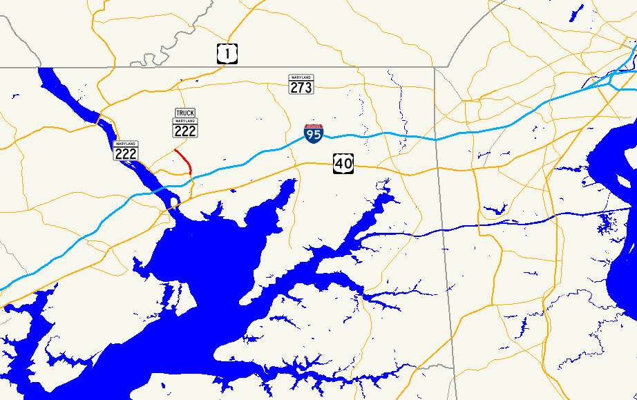
MD 276 →Maryland Route 275 (MD 275) is a state highway in the U.S. state of Maryland. Known as Perrylawn Drive, the state highway runs 2.22 miles (3.57 km) from MD 222 and MD 824 in Perryville north to MD 276 in Woodlawn in western Cecil County. MD 275 provides an eastern bypass of Port Deposit and is signed as part of MD 222 Truck. The state highway also serves to connect Rising Sun (via MD 276) and Interstate 95 (I-95). MD 275 was constructed in the mid 1960s.
Contents
Route description
MD 275 begins in Perryville at an intersection with MD 222 and MD 824 (Blythedale Road), which is the old alignment of MD 222 that serves the hamlet of Blythedale. MD 222 heads north toward Port Deposit as Bainbridge Road, while MD 222 heads south as Perryville Road toward an interchange with I-95 (John F. Kennedy Memorial Highway) and the center of Perryville. MD 275 heads north as Perrylawn Drive, a controlled-access two-lane highway, on a gradual curve through a forested area. The state highway reaches its northern terminus at MD 276 (Jacob Tome Memorial Highway) in the community of Woodlawn.[1][2]
History
MD 275 was under construction by 1966 and completed in 1967.[3][4]
Junction list
The entire route is in Cecil County.
Location Mile[1] Destinations Notes Perryville 0.00  MD 222 (Bainbridge Road/Perryville Road) / MD 824 south (Blythedale Road) to I-95 – Port Deposit
Southern terminus Woodlawn 2.22 


MD 276 / MD 222 Truck north (Jacob Tome Memorial Highway) – Rising Sun, Port DepositNorthern terminus 1.000 mi = 1.609 km; 1.000 km = 0.621 mi References
- ^ a b c "Highway Location Reference: Cecil County" (PDF). Maryland State Highway Administration. 2009. http://www.marylandroads.com/Location/2009_CECIL.pdf. Retrieved 2010-10-18.
- ^ Google, Inc. Google Maps – Maryland Route 275 (Map). Cartography by Google, Inc. http://maps.google.com/maps?f=d&source=s_d&saddr=MD-275+S%2FPerrylawn+Dr&daddr=MD-275+N%2FPerrylawn+Dr&hl=en&geocode=FRg-XAIdXk13-w%3BFfypXAIdjAZ3-w&mra=ls&sll=39.61345,-76.076455&sspn=0.030349,0.077162&ie=UTF8&t=h&z=14. Retrieved 2010-10-18.
- ^ Maryland State Roads Commission. Maryland: Official Highway Map (Map) (1966 ed.).
- ^ Maryland State Roads Commission. Maryland: Official Highway Map (Map) (1967 ed.).
External links
- MD 275 @ MDRoads.com
- MD 222 Truck signed along MD 275
Roads in Cecil County, Maryland State highways 
U.S. Highways Interstate Highways Categories:- State highways in Maryland
- Roads in Cecil County, Maryland


Wikimedia Foundation. 2010.