- Maryland Route 281
-
Maryland Route 281
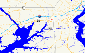
Maryland Route 281 highlighted in redRoute information Maintained by MDSHA Length: 2.12 mi[1] (3.41 km) Major junctions West end:  MD 7 in Elkton
 MD 781 near Elkton
East end: Old Baltimore Pike at the Delaware state line Location Counties: Cecil Highway system Maryland highway system
Interstate • US • State • Minor • Former • Turnpikes←  MD 280
MD 282  →
→Maryland Route 281 (MD 281) is a state highway in the U.S. state of Maryland. Known for most of its length as Red Hill Road, the state highway runs 2.12 miles (3.41 km) from MD 7 east to the Delaware state line within Elkton. MD 281 and its continuation in Delaware were originally blazed in the 18th century as part of the Old Post Road between Baltimore and Philadelphia. The state highway was part of the Elk and Christiana Turnpike in the early 19th century and later the Old Baltimore Pike, but was replaced as the main highway east from Elkton by U.S. Route 40 (US 40) in the early 20th century. The modern MD 281 was mostly constructed and marked around 1960.
Contents
Route description
MD 281 begins at an intersection with MD 7 in the town of Elkton. MD 7 continues west as Main Street and heads southeast as Delaware Avenue toward US 40.[2] MD 281 heads east as two-lane Main Street.[1] After crossing Big Elk Creek and leaving the town limits, the name of the state highway changes to Red Hill Road.[1][2] MD 281 crosses the northern flank of Grays Hill before meeting the northern end of MD 781 (Delancy Road). After crossing under transmission lines, MD 281 reaches its eastern terminus at the Delaware state line. The highway continues straight as Old Baltimore Pike toward Christiana.[2]
History
What is now MD 281 and its continuation in Delaware was the Old Post Road used to connect Christiana Bridge with the head of the Elk River, and by extension Philadelphia and Baltimore, in the 18th century.[3] Alternatively known as Old Baltimore Pike, this road was used by the French army during their march from Newport, Rhode Island to Yorktown during the Revolutionary War, passing through the area in September 1781.[4] In 1817, the Elk and Christiana Turnpike was completed along the path of the Old Post Road; the turnpike operated until 1838, when Old Baltimore Pike reverted to a public road.[3] By the 1920s, the Old Baltimore Pike was supplanted by a parallel highway to the south from Elkton to Wilmington that was chosen as the route of US 40.[5] The first segment of the modern MD 281 was a stub of state maintenance from MD 7 (then US 40) east a few blocks toward Big Elk Creek constructed around 1933.[6] This stub remained until MD 281 was completed to the Delaware state line in 1959 and 1960, when the modern bridge over Big Elk Creek was completed.[7][8]
Junction list
The entire route is in Elkton in Cecil County.
Mile
[1]Destinations Notes 0.00 MD 7 (Main Street/Delaware Avenue) – North East, Glasgow, DEWestern terminus 1.78 MD 781 south (Delancy Road)2.12 Old Baltimore Pike – Christiana, DE Eastern terminus; Delaware state line 1.000 mi = 1.609 km; 1.000 km = 0.621 mi References
- ^ a b c d "Highway Location Reference: Cecil County" (PDF). Maryland State Highway Administration. 2009. http://www.marylandroads.com/Location/2009_CECIL.pdf. Retrieved 2010-10-13.
- ^ a b c Google, Inc. Google Maps – Maryland Route 281 (Map). Cartography by Google, Inc. http://maps.google.com/maps?f=d&source=s_d&saddr=E+Main+St&daddr=MD-281+E%2FRed+Hill+Rd&hl=en&geocode=FSZnXAIdBAh7-w%3BFQiUXAIdapd7-w&mra=ls&sll=39.621598,-75.786234&sspn=0.001897,0.004823&ie=UTF8&t=h&z=15. Retrieved 2010-03-27.
- ^ a b Pfingsten, Bill (2008-08-30). "Your Gateway to Pencader Heritage Marker". The Historical Marker Database. Bel Air, MD: J.J. Prats. http://www.hmdb.org/marker.asp?marker=10874. Retrieved 2010-03-27.
- ^ "W3R Heritage Tour in Delaware". Washington-Rochambeau Revolutionary Route. The National Washington-Rochambeau Revolutionary Route Association, Inc.. 2008-04-17. http://www.w3r-us.org/tours/tour-de.htm. Retrieved 2010-03-27.
- ^ Maryland Geological Survey. Map of Maryland: Showing State Road System and State Aid Roads (Map) (1927 ed.).
- ^ Maryland Geological Survey. Map of Maryland Showing State Road System: State Aid Roads and Improved County Road Connections (Map) (1933 ed.).
- ^ Maryland State Roads Commission. Maryland: Official Highway Map (Map) (1959 ed.).
- ^ "NBI Structure Number: 100000070060010". National Bridge Inventory. http://nationalbridges.com/nbi_record.php?StateCode=24&struct=100000070060010. Retrieved 2010-10-13.
External links
Roads in Cecil County, Maryland State highways 
U.S. Highways Interstate Highways Categories:- State highways in Maryland
- Roads in Cecil County, Maryland


Wikimedia Foundation. 2010.