- Maryland Route 591
-
Maryland Route 591

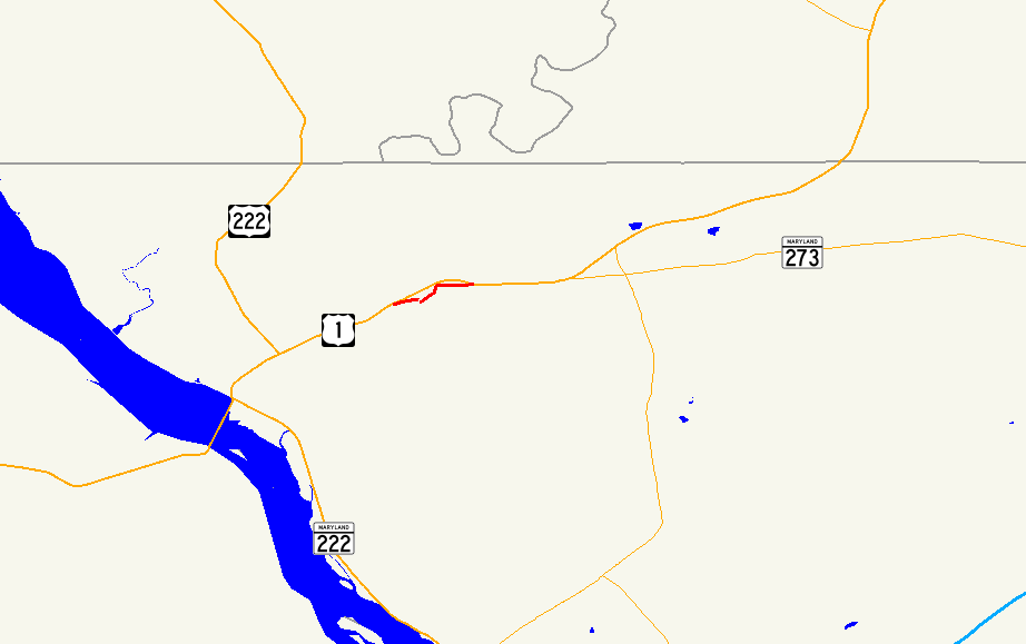
Route information Maintained by MDSHA MD 591A Length: 0.28 mi[1] (0.45 km) West end:  US 1 in Richardsmere
East end: Road end in Richardsmere MD 591B Length: 0.80 mi[1] (1.29 km) South end: Road end in Richardsmere North end: US 1 in RichardsmereLocation Counties: Cecil Highway system Maryland highway system
Interstate • US • State • Minor • Former • Turnpikes←  MD 589
I-595  →
→Maryland Route 591 (MD 591) is a collection of state highways in the U.S. state of Maryland. These highways are sections of old alignment of U.S. Route 1 (US 1) in Richardsmere between Conowingo and Rising Sun in northwestern Cecil County. MD 591A and MD 591B run on the northwest and southeast sides, respectively, of a now-removed 1885 bridge over Octoraro Creek. The state highways were bypassed when US 1 was moved to its present alignment through Richardsmere in the mid 1930s.
Contents
Route description
MD 591A is designated Colora Road and has a length of 0.28 miles (0.45 km). The state highway begins at an oblique intersection with US 1 (Conowingo Road) on the northwest side of Octoraro Creek. Opposite Colora Road is Connelly Road, the original alignment of US 1 prior to 1928. MD 591A passes a few homes and parallels the right bank of Octoraro Creek before reaching its eastern terminus at a dead end adjacent to the site of the former bridge.[1][2]
MD 591B is designated Porters Bridge Road and has a length of 0.80 miles (1.29 km). The state highway begins at a dead end adjacent to the site of the former bridge on the left bank of Octoraro Creek. MD 591B heads east, crossing Love Run and intersecting Colora Road. The state highway turns northeast, paralleling the creek to the site of the present US 1 bridge, then turns east past several homes to an oblique intersection with US 1.[2][3]
History
A bridge has existed at Richardsmere since a bridge was constructed to serve Richard Porter's mill on the northwest side of Octoraro Creek in the late 18th century.[4] A wooden covered bridge was constructed at the site around 1858 and washed away in a flood in 1884.[5] A metal Pratt through truss bridge was constructed to replace Porter's Bridge in 1885.[4] This truss bridge served the original state road, later designated US 1 in 1927.[6] The state road west toward Conowingo was paved in 1911, while the state road east toward Rising Sun was completed by 1919.[7][8] Porter's Bridge was bypassed when the relocation of US 1, including a new bridge over Octoraro Creek upstream, was completed in 1934.[9] The old alignment was designated MD 591. Porters Bridge was closed in January 1978 after a storm caused irreparable damage to the eastern approach to the bridge. The bridge was dismantled around 2002.[4]
Junction list
The entire route is in Richardsmere in Cecil County.
Mile[1] Destinations Notes 0.00 


 US 1 (Conowingo Road) / MD 222 Truck – Conowingo
Western terminus of MD 591A 0.28 Road end Eastern terminus of MD 591A Octoraro Creek 0.00 Road end Southern terminus of MD 591B 0.80
US 1 (Conowingo Road) / MD 222 Truck – Rising SunNorthern terminus of MD 591B 1.000 mi = 1.609 km; 1.000 km = 0.621 mi References
- ^ a b c d "Highway Location Reference: Cecil County" (PDF). Maryland State Highway Administration. 2009. http://www.marylandroads.com/Location/2009_CECIL.pdf. Retrieved 2010-10-19.
- ^ a b Google, Inc. Google Maps – Maryland Route 591A (Map). Cartography by Google, Inc. http://maps.google.com/maps?f=d&source=s_d&saddr=US-1+N%2FConowingo+Rd&daddr=Colora+Rd&hl=en&geocode=FTacXQIddEx2-w%3BFYygXQIdhF92-w&mra=ls&sll=39.690182,-76.128768&sspn=0.001895,0.004823&ie=UTF8&t=h&z=17. Retrieved 2010-10-19.
- ^ Google, Inc. Google Maps – Maryland Route 591B (Map). Cartography by Google, Inc. http://maps.google.com/maps?f=d&source=s_d&saddr=Colora+Rd&daddr=Porters+Bridge+Rd&hl=en&geocode=FaKeXQIdSmJ2-w%3BFTOuXQIdKJB2-w&mra=ls&sll=39.692997,-76.118764&sspn=0.003789,0.009645&ie=UTF8&t=h&z=16. Retrieved 2010-10-19.
- ^ a b c Suffness, Rita M. "Porters Bridge in Richardsmere". Elkton, MD: Historical Society of Cecil County. http://cchistory.org/porter~1.htm. Retrieved 2010-10-19.
- ^ Smedley, Jim. "Porters Covered Bridge". Maryland Covered Bridges. http://www.mdcoveredbridges.com/porters.html. Retrieved 2010-10-19.
- ^ Maryland Geological Survey. Map of Maryland: Showing State Road System and State Aid Roads (Map) (1927 ed.).
- ^ Report of the State Roads Commission of Maryland. 1912-1915. Baltimore: Maryland State Roads Commission. May 1915. p. 110. http://www.archive.org/details/annualreportsofs1912mary. Retrieved 2010-10-19.
- ^ Report of the State Roads Commission of Maryland. 1916-1919. Baltimore: Maryland State Roads Commission. January 1920. p. 43. http://www.archive.org/details/annualreportsofs1916mary. Retrieved 2010-10-19.
- ^ Report of the State Roads Commission of Maryland. 1931-1934. Baltimore: Maryland State Roads Commission. 1934-12-28. pp. 38, 44. http://www.archive.org/details/reportofstateroa1931mary. Retrieved 2010-10-19.
External links
Roads in Cecil County, Maryland State highways 
U.S. Highways Interstate Highways Categories:- State highways in Maryland
- Roads in Cecil County, Maryland


Wikimedia Foundation. 2010.