- Maryland Route 341
-
Maryland Route 341
Race Street 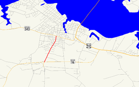
Maryland Route 341 highlighted in redRoute information Maintained by MDSHA Length: 1.25 mi[1] (2.01 km) Major junctions South end:  MD 16 in Cambridge
North end:  MD 343 in Cambridge
Location Counties: Dorchester Highway system Maryland highway system
Interstate • US • State • Minor • Former • Turnpikes←  US 340
MD 342  →
→Maryland Route 341 (MD 341) is a state highway in the U.S. state of Maryland. Known as Race Street, the state highway runs 1.25 miles (2.01 km) from MD 16 north to MD 343 within the city of Cambridge. The part of Race Street that is now MD 341 was constructed in the mid 1910s as one of the original state roads and designated MD 16 in 1927. MD 341 was assigned to the road after MD 16 bypassed Cambridge in the 1960s.
Contents
Route description
MD 341 begins at an intersection with MD 16 (Church Creek Road) and Maple Dam Road near the southern edge of the city of Cambridge adjacent to Cambridge-South Dorchester High School. Maple Dam Road heads south toward Blackwater National Wildlife Refuge and MD 16 heads east on a bypass of Cambridge toward U.S. Route 50 (US 50). MD 341 heads north, passing through fields before transitioning to residential subdivisions and then residential neighborhoods as the highway approaches the center of Cambridge. The state highway reaches its northern terminus at an intersection with MD 343 (Washington Street).[2] Race Street continues north toward downtown Cambridge as a municipal street.[1][2]
History
Race Street south of Washington Street was included as part of the Cambridge–Church Creek highway designated for improvement as a state road by the Maryland State Roads Commission in 1909.[3] That 6-mile (9.7 km) highway was completed in 1915.[4] The highway was designated part of MD 16, along with Washington Street east toward East New Market, in 1927.[5] When MD 16 was rerouted to bypass Cambridge in 1967, MD 341 was assigned to the Race Street portion of the bypassed route.[6]
Junction list
The entire route is in Cambridge in Dorchester County.
Mile[1] Destinations Notes 0.00 Maple Dam Road south – Blackwater National Wildlife Refuge Southern terminus MD 16 (Church Creek Road) – Church Creek, East New Market, Salisbury1.25 MD 343 (Washington Street) – Hudson, EastonNorthern terminus Race Street north – Downtown Cambridge 1.000 mi = 1.609 km; 1.000 km = 0.621 mi References
- ^ a b c "Highway Location Reference: Dorchester County" (PDF). Maryland State Highway Administration. 2009. http://www.marylandroads.com/Location/2009_DORCHESTER.pdf. Retrieved 2010-10-20.
- ^ a b Google, Inc. Google Maps – Maryland Route 341 (Map). Cartography by Google, Inc. http://maps.google.com/maps?f=d&source=s_d&saddr=Race+St&daddr=Cambridge,+MD&geocode=FaMrTAIdmAR3-w%3BFWZtTAIdEyF3-ynHUx7cAUq4iTEWl8tVfUpQMw&hl=en&mra=ls&sll=38.567663,-76.081867&sspn=0.015368,0.038581&ie=UTF8&t=h&z=14. Retrieved 2010-05-09.
- ^ Maryland Geological Survey. Map of Maryland (Map) (1910 ed.).
- ^ Report of the State Roads Commission of Maryland. 1912-1915. Baltimore: Maryland State Roads Commission. May 1915. p. 110. http://www.archive.org/details/annualreportsofs1912mary. Retrieved 2010-05-14.
- ^ Maryland Geological Survey. Map of Maryland: Showing State Road System and State Aid Roads (Map) (1927 ed.).
- ^ Maryland State Roads Commission. Maryland: Official Highway Map (Map) (1967 ed.).
External links
Roads in Dorchester County, Maryland State highways 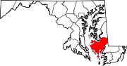
U.S. Highways Categories:- State highways in Maryland
- Roads in Dorchester County, Maryland


Wikimedia Foundation. 2010.