- Maryland Route 16
-
Maryland Route 16
Route information Maintained by MDSHA Length: 51.06 mi[1][2] (82.17 km) Major junctions West end: Taylors Island  MD 335 in Church Creek
 MD 341 in Cambridge
 US 50 near Whitehall
 MD 14 near Secretary
 MD 392 in East New Market
 MD 318 near Linchester
 MD 331 in Preston
 MD 578 in Harmony

 MD 404 / MD 313 near Denton MD 313 in Andersontown
East end:  DE 16 in Hickman
Location Counties: Dorchester, Caroline Highway system Maryland highway system
Interstate • US • State • Minor • Former • Turnpikes←  US 15
US 15MD 17  →
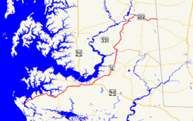
→Maryland Route 16 (MD 16) is a state highway in the U.S. state of Maryland. The state highway runs 51.06 miles (82.17 km) from Taylors Island east to the Delaware state line in Hickman, where the highway continues as Delaware Route 16 (DE 16). MD 16 connects Cambridge with several communities in northern Dorchester County and southwestern Caroline, including East New Market and Preston. The state highway runs concurrently with U.S. Route 50 (US 50) near Cambridge, MD 331 between East New Market and Preston, and both MD 404 and MD 313 near Andersontown. The state highway is a part of the National Highway System along its concurrencies with US 50 and MD 404.[3] MD 16 was constructed between Church Creek and Preston as one of the original state roads in the early and mid-1910s. The highway was extended in both directions in the late 1910s: north to what was to be designated MD 313 near Denton and west to Taylors Island. MD 16 was extended through Andersontown to the Delaware state line in the early 1930s. MD 16's bypass of Cambridge was constructed in the mid-1960s.
Contents
Route description
Dorchester County
MD 16 begins on Taylors Island a short distance west of the bridge over Slaughter Creek to the mainland. The roadway continues west as county-maintained Hoopers Neck Road, which provides access to the historic Ridgeton Farm, Grace Episcopal Church Complex, and Bethlehem Methodist Episcopal Church. MD 16 heads northeast from the island as two-lane Taylors Island Road. The state highway crosses Parsons Creek and passes through the hamlets of Madison and Woolford on its way to the town of Church Creek, where MD 16 intersects MD 335 (Golden Hill Road). MD 16 continues northeast as Church Creek Road toward Cambridge, where the state highway intersects MD 341 (Race Street), which is the old alignment of MD 16, just beyond Cambridge-South Dorchester High School along the southern edge of the city. MD 16 continues east and intersects the Seaford Line of the Maryland and Delaware Railroad, then curves north to US 50 (Ocean Gateway). The state highway joins US 50 in a concurrency along the four-lane divided highway. US 50 and MD 16 intersect Bucktown Road, which leads southeast to Cambridge-Dorchester Airport, and both ends of MD 750 (Old Route 50) before reaching the eastern end of the concurrency in the community of Whitehall, also known as Mount Holly.[1][4]
MD 16 heads northeast from US 50 as two-lane Mount Holly Road. As the state highway approaches East New Market, the western terminus of MD 14 (Secretary Road) heads north toward Secretary and MD 392 (East New Market Bypass) heads northeast toward Hurlock. MD 16 turns north into the town, where the highway passes through the East New Market Historic District as Main Street. The state highway intersects MD 14 (Railroad Avenue) before leaving town as East New Market Ellwood Road. MD 16 crosses the Warwick River and Cabin Creek before meeting MD 331 (Waddells Corner Road) at Waddells Corner. MD 16 joins MD 331 in a concurrency that crosses Gravel Creek and passes Beulah Road, the old alignment of MD 16 and MD 331 through Ellwood. After an at-grade crossing of the Preston Branch of the Seaford Line of the Maryland and Delaware Railroad, the two state highways intersect MD 318 (Preston Road) and continue northwest as Preston Road, which passes near the Jacob and Hannah Leverton House before crossing Hunting Creek into Caroline County.[1][4]
Caroline County
The MD 16–MD 331 concurrency continues northwest through Linchester, where the highway passes both ends of MD 817 (Linchester Road), which provides access to the historic Linchester Mill. The state highways continue through the town of Preston as Main Street. Unsigned MD 324 (Maple Avenue) heads south from MD 16 and MD 331 before the two highways split on the west side of town. MD 16 heads north as Harmony Road through the hamlet of Grove and intersects MD 578 (Bethlehem Road) in the community of Harmony. The state highway crosses Fowling Creek and Robins Creek and passes through the hamlet of Two Johns, which is also known as Bureau.[2][4]
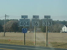
As MD 16 passes to the west of Williston Lake, an impoundment of Mill Creek, the highway closely parallels its old alignment, MD 617. The state highway passes through the Williston Mill Historic District just east of the community of Williston, which contains the historic homes Potter Hall and Memory Lane. MD 16 continues northeast until reaching an intersection with MD 404 and MD 313 (Shore Highway) south of Denton. MD 16 turns southeast onto Shore Highway, a four-lane divided highway that reduces to two lanes east of the intersection, to form a triple state highway concurrency. The three state highways continue east to Andersontown, where MD 313 heads south as Federalsburg Highway. A short distance to the east, MD 404 continues straight southeast while MD 16 turns northeast onto Greenwood Road. Shortly thereafter, MD 16 reaches its eastern terminus at the Delaware state line in Hickman. The highway continues east as DE 16 (Hickman Road) toward Greenwood.[2][4]
History
The portion of MD 16 between Church Creek and East New Market via Cambridge was chosen as one of the original state roads by the Maryland State Roads Commission in 1909.[5] The portion of the highway between Bureau and the western junction with MD 313 and MD 404 south of Denton was also included in the planned state road system; that piece of highway was the first part of modern MD 16 completed in 1910.[5][6] MD 16 was completed from Mount Holly to East New Market in 1911, from Cambridge to Mount Holly in 1913, from East New Market to Preston via Linchester in 1914, and from Church Creek to Cambridge in 1915. The gap in the state highway within East New Market was closed in 1917.[7] The segment of highway between Preston and Grove was surfaced by 1915.[6] MD 16 between Grove and Bureau was under construction by 1919 and finished around 1920. The state highway was constructed from the bridge to Taylor's Island to Church Creek between 1917 and 1919.[7]
When numbers were assigned to state highways in Maryland in 1927, MD 16 had a concurrency with US 213 between Waddell's Corner and Preston.[8] Greenwood Road from MD 404 in Andersontown to the Delaware state line was built between 1930 and 1933, concurrent with the completion of the connecting section of MD 404.[9][10] MD 16 was extended north and east through Andersontown to the Delaware state line by 1939, giving the state highway additional concurrencies with MD 313 and MD 404. Also in 1939, US 213 between Easton and Vienna was transferred to a new route via Cambridge; the old portion of US 213 was designated MD 331 and the new section of US 213 became concurrent with MD 16 between Cambridge and Mount Holly.[11] Within Cambridge, MD 16 followed Race Street north to Washington Street, which the highway followed east toward Mount Holly.[12]
The next changes in MD 16 occurred in the 1950s. MD 16 was extended west across Slaughter Creek to Taylors Island when a new bridge was completed in 1950.[13] MD 313 was moved to its present alignment between Federalsburg and Denton in 1954; as a result, MD 16 became the sole route from Bureau to MD 404 south of Denton and part of a triple concurrency from there to Andersontown.[14] US 50, which had replaced US 213 from Ocean City to Wye Mills in 1949, was expanded to a divided highway along its concurrency with MD 16 by 1955.[15][16][17] MD 331 and MD 16 were realigned around Ellwood and Linchester around 1960.[18][19] MD 16 was relocated to bypass Cambridge in 1967; the state highway's old route through the city was transferred to newly designated MD 341 and an extension of MD 343 east to US 50.[20] MD 16 was relocated at Williston Lake shortly after the construction of a new bridge across the lake's outlet, Mill Creek, in 1968.[21] The state highway was straightened out through Madison in 1970, leaving behind Old Madison Road.[22]
Junction list
County Location Mile
[1][2]Destinations Notes Dorchester Taylors Island 0.00 Hoopers Neck Road west Western terminus Church Creek 9.56 MD 335 south (Golden Hill Road) – Hoopers IslandCambridge 14.60 MD 341 north (Race Street) / Maple Dam Road south16.90 US 50 west (Ocean Gateway) – EastonWest end of concurrency with US 50 17.31  MD 750 east (Old Route 50) / Bucktown Road south
18.11 MD 750 west (Old Route 50)Whitehall 19.56 US 50 east (Ocean Gateway) – SalisburyEast end of concurrency with US 50 East New Market 23.52 MD 14 east (Secretary Road) – Secretary24.41 MD 392 east (East New Market Bypass) – Hurlock25.17 MD 14 (Railroad Avenue) – Secretary, EldoradoWaddells Corner 29.15 MD 331 south (Waddells Corner Road) – HurlockWest end of concurrency with MD 331 Linchester 32.47 MD 318 east (Preston Road) – FederalsburgCaroline 32.69  MD 817 north (Linchester Road)
Officially MD 817A Preston 33.11 MD 817 south (Linchester Road)33.66 Maple Avenue south – Choptank Unsigned MD 324 33.73 MD 331 north (Main Street) – EastonEast end of concurrency with MD 331 Harmony 38.85 MD 578 west (Bethlehem Road) – BethlehemDenton 45.39 MD 404 west / MD 313 north (Shore Highway) – Denton, Bay BridgeWest end of concurrency with MD 404 / MD 313 Andersontown 47.67 MD 313 south (Federalsburg Highway) – FederalsburgEast end of concurrency with MD 313 48.56 MD 404 east (Shore Highway) – BridgevilleEast end of concurrency with MD 404 Hickman 51.06 DE 16 east (Hickman Road) – GreenwoodEastern terminus; Delaware state line 1.000 mi = 1.609 km; 1.000 km = 0.621 mi Auxiliary route
MD 16A is the designation for the 0.04-mile (0.064 km) section of Beauchamp Branch Road between MD 16 and its old alignment, MD 617, just south of Williston Lake near Williston.[2][23]
References
- ^ a b c d "Highway Location Reference: Dorchester County" (PDF). Maryland State Highway Administration. 2009. http://www.marylandroads.com/Location/2009_DORCHESTER.pdf. Retrieved 2010-08-12.
- ^ a b c d e "Highway Location Reference: Caroline County" (PDF). Maryland State Highway Administration. 2009. http://www.marylandroads.com/Location/2009_CAROLINE.pdf. Retrieved 2010-08-12.
- ^ Federal Highway Administration (August 2003) (PDF). National Highway System: Maryland (Map). http://www.fhwa.dot.gov/planning/nhs/maps/md/md_Maryland.pdf. Retrieved 2011-04-05.
- ^ a b c d Google, Inc. Google Maps – Maryland Route 16 (Map). Cartography by Google, Inc. http://maps.google.com/maps?f=d&source=s_d&saddr=MD-16+E%2FTaylors+Island+Rd&daddr=Main+St+to:MD-16+E%2FGreenwood+Rd&geocode=FaT_SgId7NBz-w%3BFYi1TgIdFLp5-w%3BFa6LUAId_o58-w&hl=en&mra=ls&sll=38.828475,-75.701294&sspn=0.061381,0.154324&ie=UTF8&t=h&z=10. Retrieved 2010-08-12.
- ^ a b Maryland Geological Survey. Map of Maryland (Map) (1910 ed.).
- ^ a b Report of the State Roads Commission of Maryland. 1912-1915. Baltimore: Maryland State Roads Commission. May 1915. pp. 108–110. http://www.archive.org/details/annualreportsofs1912mary. Retrieved 2010-08-12.
- ^ a b Report of the State Roads Commission of Maryland. 1916-1919. Baltimore: Maryland State Roads Commission. January 1920. pp. 49, 52. http://www.archive.org/details/annualreportsofs1916mary. Retrieved 2010-08-12.
- ^ Maryland Geological Survey. Map of Maryland: Showing State Road System and State Aid Roads (Map) (1927 ed.).
- ^ Report of the State Roads Commission of Maryland. 1927-1930. Baltimore: Maryland State Roads Commission. 1930-10-01. p. 201. http://www.archive.org/details/reportofstateroa1927mary. Retrieved 2010-08-12.
- ^ Maryland Geological Survey. Map of Maryland Showing State Road System: State Aid Roads and Improved County Road Connections (Map) (1933 ed.).
- ^ Maryland State Roads Commission. General Highway Map: State of Maryland (Map) (1939 ed.).
- ^ Maryland State Roads Commission. Map of Maryland Showing Highways and Points of Interest (Map) (1940 ed.).
- ^ Maryland State Roads Commission. Maryland: Official Highway Map (Map) (1950 ed.).
- ^ Maryland State Roads Commission. Maryland: Official Highway Map (Map) (1954 ed.).
- ^ Maryland State Roads Commission. Maryland: Official Highway Map (Map) (1949 ed.).
- ^ Maryland State Roads Commission. Maryland: Official Highway Map (Map) (1955 ed.).
- ^ Report of the State Roads Commission of Maryland. 1953-1954. Baltimore: Maryland State Roads Commission. 1954-11-12. p. 133. http://www.archive.org/details/annualreportsofs1953mary. Retrieved 2010-08-12.
- ^ "NBI Structure Number: 100000050014020". National Bridge Inventory. http://nationalbridges.com/nbi_record.php?StateCode=24&struct=100000050014020. Retrieved 2010-10-05.
- ^ Maryland State Roads Commission. Maryland: Official Highway Map (Map) (1960 ed.).
- ^ Maryland State Roads Commission. Maryland: Official Highway Map (Map) (1967 ed.).
- ^ "NBI Structure Number: 100000050001010". National Bridge Inventory. http://nationalbridges.com/nbi_record.php?StateCode=24&struct=100000050001010. Retrieved 2011-04-05.
- ^ Maryland State Roads Commission. Maryland: Official Highway Map (Map) (1970 ed.).
- ^ Google, Inc. Google Maps – Maryland Route 16A (Map). Cartography by Google, Inc. http://maps.google.com/maps?f=d&source=s_d&saddr=MD-16+E%2FHarmony+Rd&daddr=Beauchamp+Branch+Rd&hl=en&geocode=FYJsUAIdSLB6-w%3BFdhsUAIdorJ6-w&mra=ls&sll=38.825859,-75.844545&sspn=0.00377,0.009645&ie=UTF8&ll=38.82555,-75.844674&spn=0.007539,0.01929&t=h&z=16. Retrieved 2011-04-05.
External links
Roads in Caroline County, Maryland State highways 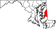
Roads in Dorchester County, Maryland State highways 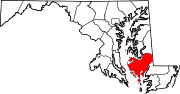
U.S. Highways Categories:- State highways in Maryland
- Roads in Caroline County, Maryland
- Roads in Dorchester County, Maryland


Wikimedia Foundation. 2010.