- Maryland Route 287
-
Maryland Route 287
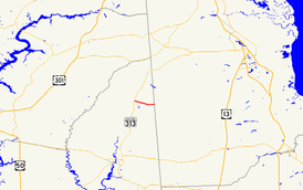
Maryland Route 287 highlighted in redRoute information Maintained by MDSHA Length: 2.88 mi[1] (4.63 km) Major junctions West end:  MD 313 in Goldsboro
 MD 311 in Goldsboro
East end:  DE 10 near Goldsboro
Location Counties: Caroline Highway system Maryland highway system
Interstate • US • State • Minor • Former • Turnpikes←  MD 286
MD 288  →
→Maryland Route 287 (MD 287) is a state highway in the U.S. state of Maryland. Known for much of its length as Sandtown Road, the state highway runs 2.88 miles (4.63 km) from MD 313 in Goldsboro east to the Delaware state line, where the highway continues east as Delaware Route 10 (DE 10). MD 287 was constructed in the early 1930s.
Contents
Route description
MD 287 begins at an intersection with MD 313 on the northwest edge of Goldsboro. MD 313 heads south into the town as Oldtown Road and west as Goldsboro Road. MD 287 heads east as Old Line Road along the northern edge of Goldsboro. After intersecting MD 311 (Main Street) and crossing an unused railroad grade owned by the Maryland Department of Transportation, the state highway's name changes to Sandtown Road and it heads east through farmland, crossing Broadway Branch and the upper part of the Choptank River.[1][2] MD 287 reaches its eastern terminus at the Delaware state line, where the highway continues east as DE 10 (Willow Grove Road) toward Dover.[2]
History
MD 287 was constructed starting in 1930 and completed by 1933.[3][4]
Junction list
The entire route is in Goldsboro in Caroline County.
Mile
[1]Destinations Notes 0.00 MD 313 (Goldsboro Road/Oldtown Road) – Sudlersville, GreensboroWestern terminus 0.29 MD 311 (Main Street) – Marydel2.88 DE 10 east (Willow Grove Road) – DoverEastern terminus References
- ^ a b c "Highway Location Reference: Caroline County" (PDF). Maryland State Highway Administration. 2009. http://www.marylandroads.com/Location/2009_CAROLINE.pdf. Retrieved 2010-08-11.
- ^ a b Google, Inc. Google Maps – Maryland Route 287 (Map). Cartography by Google, Inc. http://maps.google.com/maps?f=d&source=s_d&saddr=Goldsboro+Rd%2FOld+Line+Rd&daddr=MD-287+E%2FSandtown+Rd&geocode=FWayUwIdYot7-w%3BFZyLUwIdUFF8-w&hl=en&mra=ls&sll=39.038786,-75.784893&sspn=0.015233,0.038581&ie=UTF8&t=h&z=14. Retrieved 2010-05-15.
- ^ Report of the State Roads Commission of Maryland. 1927-1930. Baltimore: Maryland State Roads Commission. 1930-10-01. p. 201. http://www.archive.org/details/reportofstateroa1927mary. Retrieved 2010-08-11.
- ^ Maryland Geological Survey. Map of Maryland Showing State Road System: State Aid Roads and Improved County Road Connections (Map) (1933 ed.).
External links
Roads in Caroline County, Maryland State highways 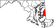 Categories:
- State highways in Maryland
- Roads in Caroline County, Maryland


Wikimedia Foundation. 2010.