- Maryland Route 454
-
Maryland Route 454
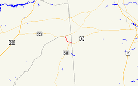
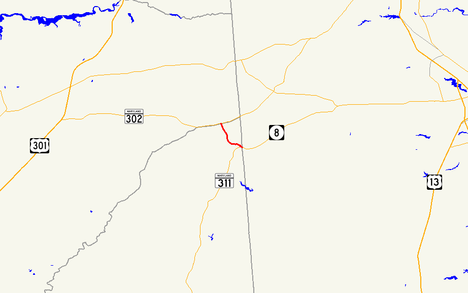
Maryland Route 454 highlighted in redRoute information Maintained by MDSHA Length: 2.21 mi[1] (3.56 km) Major junctions South end:  DE 8 in Marydel
 MD 311 in Marydel
North end:  MD 302 in Templeville
Location Counties: Caroline Highway system Maryland highway system
Interstate • US • State • Minor • Former • Turnpikes←  MD 452
MD 456  →
→Maryland Route 454 (MD 454) is a state highway in the U.S. state of Maryland. Known for most of its length as Crown Stone Road, the state highway runs 2.21 miles (3.56 km) from the Delaware state line in Marydel, where the highway continues east as Delaware Route 8 (DE 8), north to MD 302 in Templeville. MD 454 was built in the late 1910s. The state highway originally ended in Marydel at MD 311, which crossed the state line. MD 454 replaced MD 311 along the stretch to the state line around 1946 and bypassed Marydel by 1956.
Contents
Route description
MD 454 begins at the Delaware state line in the town of Marydel, adjacent to a five-mile (8 km) Mason–Dixon marker that gives the highway its name.[2] The highway continues east as DE 8 (Halltown Road) toward Dover. The state highway immediately encounters the eastern end of MD 821 (Main Street) and crosses an unused railroad grade owned by the Maryland Department of Transportation.[3] MD 454 meets the northern terminus of MD 311 (Henderson Road) before leaving Marydel and collecting the other end of MD 821.[1] The state highway turns north through farmland before entering the town of Templeville and terminating at MD 302 (Barclay Road), which forms the border between Caroline County and Queen Anne's County.[1][3]
History
MD 454 was paved as a state-aid road from Marydel to Templeville between 1915 and 1921.[4][5] The state highway originally had its southern terminus in Marydel at MD 311. It was MD 311 that crossed the state line until 1946.[6][7] MD 454 was moved off of Main Street and onto a new alignment through Marydel by 1956.[8]
Junction list
The entire route is in Caroline County.
Location Mile
[1]Destinations Notes Marydel 0.00 DE 8 east (Halltown Road) – DoverSouthern terminus 0.03  MD 821 west (Main Street)
0.11 MD 311 south (Henderson Road) – Goldsboro0.36 MD 821 east (Main Street)Templeville 2.21 MD 302 (Barclay Road) – Barclay, SmyrnaNorthern terminus 1.000 mi = 1.609 km; 1.000 km = 0.621 mi References
- ^ a b c d "Highway Location Reference: Caroline County" (PDF). Maryland State Highway Administration. 2009. http://www.marylandroads.com/Location/2009_CAROLINE.pdf. Retrieved 2010-09-04.
- ^ "Mason–Dixon Crown Stone". Delaware Public Archives. 2009-12-30. http://archives.delaware.gov/markers/kc/KC-69.shtml. Retrieved 2010-05-16.
- ^ a b Google, Inc. Google Maps – Maryland Route 454 (Map). Cartography by Google, Inc. http://maps.google.com/maps?f=d&source=s_d&saddr=Crown+Stone+Rd&daddr=Crown+Stone+Rd%2FMD-454+S&geocode=FaLPVAIdjjZ8-w%3BFTAtVQIdAuZ7-w&hl=en&mra=ls&sll=39.126997,-75.753565&sspn=0.030428,0.077162&ie=UTF8&ll=39.1246,-75.755968&spn=0.030429,0.077162&t=h&z=14. Retrieved 2010-05-16.
- ^ Report of the State Roads Commission of Maryland. 1912-1915. Baltimore: Maryland State Roads Commission. May 1915. p. 128. http://www.archive.org/details/annualreportsofs1912mary. Retrieved 2010-09-04.
- ^ Maryland Geological Survey. Map of Maryland: Showing State Road System and State Aid Roads (Map) (1921 ed.).
- ^ Maryland State Roads Commission. General Highway Map: State of Maryland (Map) (1939 ed.).
- ^ Maryland State Roads Commission. Maryland: Official Highway Map (Map) (1946-47 ed.).
- ^ Report of the State Roads Commission of Maryland. 1955-1956. Baltimore: Maryland State Roads Commission. 1956-11-02. p. 138. http://www.archive.org/details/reportofstateroa1955mary. Retrieved 2010-09-04.
External links
Roads in Caroline County, Maryland State highways 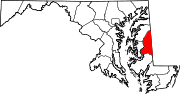 Categories:
- State highways in Maryland
- Roads in Caroline County, Maryland


Wikimedia Foundation. 2010.