- Maryland Route 311
-
Maryland Route 311
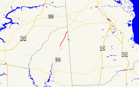
Maryland Route 311 highlighted in redRoute information Maintained by MDSHA Length: 6.11 mi[1] (9.83 km) Major junctions South end:  MD 313 in Goldsboro
 MD 287 in Goldsboro
North end:  MD 454 in Marydel
Location Counties: Caroline Highway system Maryland highway system
Interstate • US • State • Minor • Former • Turnpikes←  MD 310
MD 312  →
→Maryland Route 311 (MD 311) is a state highway in the U.S. state of Maryland. Known for most of its length as Henderson Road, the state highway runs 6.11 miles (9.83 km) from MD 313 in Goldsboro north to MD 454 in Marydel. MD 311 was constructed in the mid 1920s. The state highway originally continued through Marydel to the Delaware state line, but was rolled back in favor of MD 454 in the mid 1940s.
Contents
Route description
MD 311 begins at an intersection with MD 313 (Oldtown Road) in the town of Goldsboro. The state highway, named Main Street, heads north, closely paralleling an unused rail line whose right of way is owned by the Maryland Department of Transportation. After intersecting MD 287 (Sandtown Road), MD 311 leaves the town of Goldsboro and the vicinity of the rail line and the highway's name changes to Henderson Road. The state highway crosses Broadway Branch before rejoining the rail line immediately before the intersection with River Bridge Road, where the highway enters the town of Henderson. After leaving Henderson, MD 311 veers away from the rail line and crosses Cold Spring Branch.[1][2] The state highway passes through a mix of farms and forests as it approaches the town of Marydel.[2] Within the town, the state highway intersects Main Street, which is unsigned MD 821, shortly before reaching its northern terminus at MD 454 (Crown Stone Road).[1][2]
History
MD 311 was constructed in its modern form in 1924.[3][4] At the time, the state highway turned east onto Main Street in Marydel and followed it to the Delaware state line.[4][5] By 1946, MD 311's northern terminus was rolled back to Main Street and MD 454 headed to the state line instead.[6] MD 311 was widened along its entire length in 1952.[7] The state highway was extended a short distance to its present northern terminus when MD 454 was transferred to a new alignment in Marydel in 1956.[8]
Junction list
The entire route is in Caroline County.
Location Mile
[1]Destinations Notes Goldsboro 0.00 MD 313 (Oldtown Road) – Greensboro, SudlersvilleSouthern terminus 0.27 MD 287 (Sandtown Road) – DoverMarydel 6.06  MD 821 (Main Street)
MD 821 is unsigned 6.11 MD 454 (Crown Stone Road) – Templeville, DoverNorthern terminus 1.000 mi = 1.609 km; 1.000 km = 0.621 mi References
- ^ a b c d "Highway Location Reference: Caroline County" (PDF). Maryland State Highway Administration. 2009. http://www.marylandroads.com/Location/2009_CAROLINE.pdf. Retrieved 2010-08-24.
- ^ a b c Google, Inc. Google Maps – Maryland Route 311 (Map). Cartography by Google, Inc. http://maps.google.com/maps?f=d&source=s_d&saddr=MD-311+N&daddr=Halltown+Rd%2FHenderson+Rd&geocode=FSKcUwIdxpV7-w%3BFSbTVAIdVjJ8-w&hl=en&mra=ls&sll=39.046119,-75.744553&sspn=0.121853,0.308647&ie=UTF8&ll=39.073578,-75.766869&spn=0.121806,0.308647&t=h&z=12. Retrieved 2010-05-14.
- ^ Report of the State Roads Commission of Maryland. 1924-1926. Baltimore: Maryland State Roads Commission. January 1927. p. 71. http://www.archive.org/details/annualreportsofs1924mary. Retrieved 2010-08-24.
- ^ a b Maryland Geological Survey. Map of Maryland: Showing State Road System and State Aid Roads (Map) (1927 ed.).
- ^ Maryland State Roads Commission. General Highway Map: State of Maryland (Map) (1939 ed.).
- ^ Maryland State Roads Commission. Maryland: Official Highway Map (Map) (1946-47 ed.).
- ^ Report of the State Roads Commission of Maryland. 1951-1952. Baltimore: Maryland State Roads Commission. 1952-12-15. p. 125. http://www.archive.org/details/reportofstateroa1951mary. Retrieved 2010-08-24.
- ^ Report of the State Roads Commission of Maryland. 1955-1956. Baltimore: Maryland State Roads Commission. 1956-11-02. p. 138. http://www.archive.org/details/reportofstateroa1955mary. Retrieved 2010-08-24.
External links
Roads in Caroline County, Maryland State highways 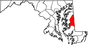 Categories:
- State highways in Maryland
- Roads in Caroline County, Maryland


Wikimedia Foundation. 2010.