- Maryland Route 317
-
Maryland Route 317
Burrsville Road 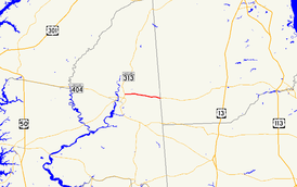
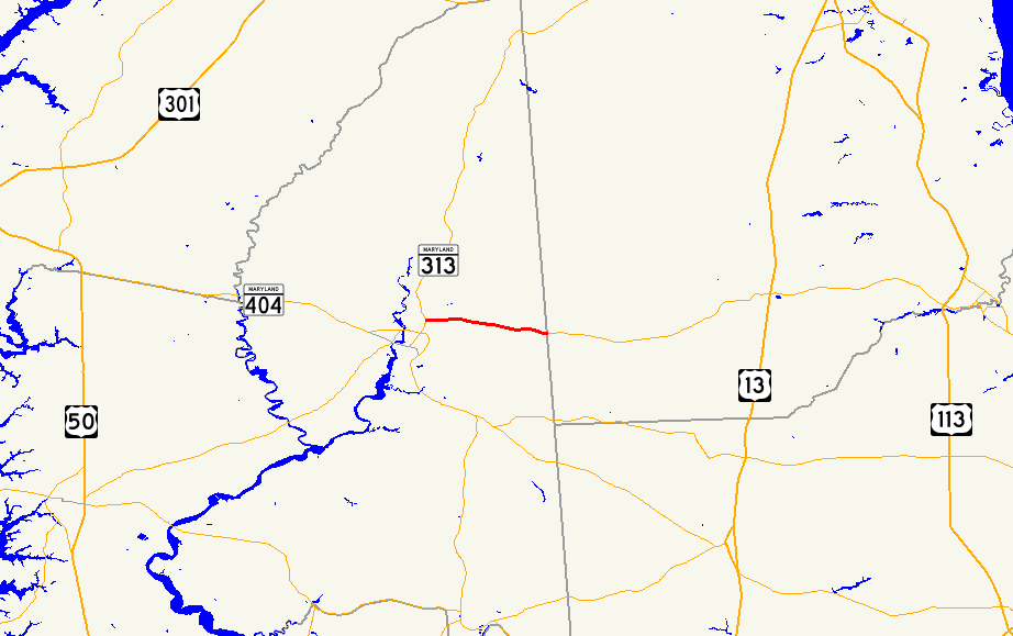
Maryland Route 317 highlighted in redRoute information Maintained by MDSHA Length: 4.78 mi[1] (7.69 km) Major junctions West end:  MD 313 in Oil City
East end:  DE 14 in Burrsville
Location Counties: Caroline Highway system Maryland highway system
Interstate • US • State • Minor • Former • Turnpikes←  MD 316
MD 318  →
→Maryland Route 317 (MD 317) is a state highway in the U.S. state of Maryland. Known as Burrsville Road, the state highway runs 4.78 miles (7.69 km) from MD 313 in Oil City east to the Delaware state line in Burrsville, where the highway continues east as Delaware Route 14 (DE 14). MD 317 was constructed in the mid 1920s and realigned through Burrsville around 1960.
Contents
Route description
MD 317 begins at an intersection with MD 313 (Greensboro Road) in Oil City.[1] The state highway heads east through farmland. MD 317 crosses Webber Branch before the old alignment, Ruritan Road, splits to the northeast as the highway approaches Burrsville.[2] The old alignment, now part of Knife Box Road, crosses MD 317 again shortly before the Delaware state line.[1][2] The highway continues east as DE 14 (Vernon Road) toward Harrington.[2]
History
MD 317 was paved in 1925 and 1926 along its whole length.[3][4] The state highway originally performed an S-curve through Burrsville, following present day Ruritan Road and Knife Box Road, which was designated MD 457 north of MD 317 between 1951 and 1960.[5][6] MD 317 was constructed on its present straight alignment through Burrsville around 1960.[6]
Junction list
The entire route is in Caroline County.
Location Mile
[1]Destinations Notes Oil City 0.00 MD 313 (Greensboro Road) – Denton, GreensboroWestern terminus Burrsville 4.67 Knife Box Road – Greensboro Former MD 457 4.78 DE 14 east (Vernon Road) – Harrington, DEEastern terminus 1.000 mi = 1.609 km; 1.000 km = 0.621 mi References
- ^ a b c d "Highway Location Reference: Caroline County" (PDF). Maryland State Highway Administration. 2009. http://www.marylandroads.com/Location/2009_CAROLINE.pdf. Retrieved 2010-09-03.
- ^ a b c Google, Inc. Google Maps – Maryland Route 317 (Map). Cartography by Google, Inc. http://maps.google.com/maps?f=d&source=s_d&saddr=Burrsville+Rd%2FMD-317+E&daddr=Burrsville+Rd%2FMD-317+E&hl=en&geocode=FbalUQId2Cl7-w%3BFZl_UQIdSnt8-w&mra=ls&sll=38.901055,-75.771245&sspn=0.061052,0.154324&ie=UTF8&t=h&z=13. Retrieved 2010-05-13.
- ^ Report of the State Roads Commission of Maryland. 1924-1926. Baltimore: Maryland State Roads Commission. January 1927. pp. 35, 71. http://www.archive.org/details/annualreportsofs1924mary. Retrieved 2010-09-03.
- ^ Maryland Geological Survey. Map of Maryland: Showing State Road System and State Aid Roads (Map) (1927 ed.).
- ^ Maryland State Roads Commission. Maryland: Official Highway Map (Map) (1951 ed.).
- ^ a b Maryland State Roads Commission. Maryland: Official Highway Map (Map) (1960 ed.).
External links
Roads in Caroline County, Maryland State highways 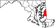 Categories:
- State highways in Maryland
- Roads in Caroline County, Maryland


Wikimedia Foundation. 2010.