- Maryland Route 318
-
Maryland Route 318

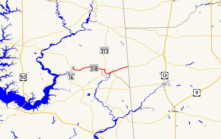
Maryland Route 318 highlighted in redRoute information Maintained by MDSHA Length: 11.32 mi[1][2] (18.22 km) Major junctions West end: 
 MD 16 / MD 331 near Preston
 MD 313 / MD 315 in Federalsburg
 MD 307 in Federalsburg
MD 313 in Federalsburg MD 315 in FederalsburgEast end:  DE 18 near Federalsburg
Location Counties: Dorchester, Caroline Highway system Maryland highway system
Interstate • US • State • Minor • Former • Turnpikes←  MD 317
MD 320  →
→Maryland Route 318 (MD 318) is a state highway in the U.S. state of Maryland. The state highway runs 11.32 miles (18.22 km) from MD 16 and MD 331 near Preston east to the Delaware state line near Federalsburg, where the highway continues east as Delaware Route 18 (DE 18). MD 318 follows the Dorchester–Caroline county line for most of its length between Preston and Federalsburg. The county line road is considered to be in Caroline County for maintenance purposes.[3] Further east, MD 318 runs concurrently with MD 313 to bypass Federalsburg. The portion of MD 318 west of Federalsburg was originally numbered MD 319 and assumed by MD 318 in the mid 1950s. The MD 319 section was constructed in the late 1910s near Federalsburg and completed west to MD 331 and MD 16 in the late 1920s. MD 318 east of Federalsburg was built in the mid 1920s. MD 318 was placed on the bypass of Federalsburg in the early 1960s; its old alignment through Federalsburg became MD 315.
Contents
Route description
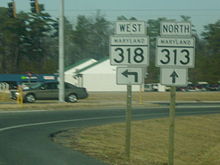 Northern split of MD 313 and MD 318 in Federalsburg
MD 318 begins at an intersection with MD 16 and MD 331 at the hamlet of Ellwood near Preston, just south of the Caroline–Dorchester county line. MD 16 and MD 331 head south from the intersection as East New Market Ellwood Road and west as a continuation of Preston Road toward the center of Preston. MD 318 heads east as Preston Road, a two-lane road that intersects Langrell Road and Beulah Road a short distance east of its western terminus.[1][4] Langrell Road is unsigned MD 817B, which follows the county line west to a dead end at Hunting Creek. MD 318 continues east on top of the county line through farmland between Dorchester County to the south and Carolina County to the north. The state highway intersects American Corner Road and passes Magennis Farm Airport in the hamlet of Hynson. MD 318 fully enters Caroline County shortly after passing Lovers Road, then intersects MD 313 (Federalsburg Highway) and MD 315 (Bloomingdale Avenue). MD 315, the old alignment of MD 318, continues straight east toward downtown Federalsburg, while MD 318 turns south and runs concurrently with MD 313 on a bypass of Federalsburg.[2][4]
MD 313 and MD 318 intersect MD 307 (Williamsburg Road) at the Federalsburg Roundabout. The highway crosses the Seaford Line of the Maryland and Delaware Railroad at-grade as the highway gently curves to the east. After passing Main Street, which is unsigned MD 308, MD 313 and MD 318 cross Marshyhope Creek. East of the creek, MD 313 (Reliance Road) turns south onto Reliance Road; the old alignment of MD 313, heads north toward downtown Federalsburg as Reliance Avenue. MD 318 continues east through an industrial area along Federalsburg Highway, which crosses the Seaford Line track again. The state highway crosses Tanyard Branch before meeting the other end of MD 315 (Liberty Road). MD 318 continues east as Bridgeville Road to the Delaware state line, where the highway heads toward Bridgeville as DE 18 (Federalsburg Road).[2][4]
History
The portion of MD 318 between Preston and Federalsburg was originally MD 319, which was constructed as a state-aid road from Federalsburg to about halfway to Hynson around 1919.[5][6] The state highway was completed west to U.S. Route 213 (now MD 331) and MD 16 near Preston by 1930.[7] MD 318 from Federalsburg to the Delaware state line was built between 1924 and 1926.[8][9] MD 318 was extended west through Federalsburg and over the whole length of MD 319 in 1956.[10] The state highway west of Federalsburg was widened around 1958 and extended west fully into Dorchester County to its present terminus when MD 331 and MD 16 were relocated around Ellwood in 1960.[11][12] MD 318 was placed on the Federalsburg Bypass when the highway was extended south and east around the town to the present intersection with MD 315 in 1964; MD 318 through the town was renumbered MD 315.[13] The Federalsburg Roundabout was constructed in 1998.[14] The Federalsburg Bypass bridge over Marshyhope Creek, which was originally built in 1962, will be rehabilitated in 2012.[15][16] During the project, which will replace the bridge's deck, alternating one-way traffic will cross the bridge directed by traffic lights at either end of the construction area.[16]
Junction list
MD 318 follows the Caroline–Dorchester county line between the intersection with MD 817 near Preston and a point between Lovers Road and MD 313 near Federalsburg. The county line portion is considered to be in Caroline County for maintenance purposes.[3]
County Location Mile
[1][2]Destinations Notes Dorchester Preston 0.00 MD 16 (Preston Road/East New Market Ellwood Road) / MD 331 – Easton, Denton, CambridgeWestern terminus 0.37 Langrell Road north / Beulah Road south Langrell Road is unsigned MD 817B Caroline Federalsburg 6.05 MD 313 north (Federalsburg Highway) / MD 315 east (Bloomingdale Avenue) – DentonWest end of concurrency with MD 313; MD 315 is old alignment of MD 318 6.51 MD 307 (Williamsburg Road) – HurlockFederalsburg Roundabout 7.73 Main Street north / Veterans Drive south Main Street is unsigned MD 308 8.24 MD 313 south (Reliance Road) / Reliance Avenue north – EldoradoEast end of concurrency with MD 313; Reliance Avenue is old alignment of MD 313 9.91 MD 315 west (Liberty Road)Old alignment of MD 318 11.32 DE 18 east (Federalsburg Road) – BridgevilleEastern terminus; Delaware state line 1.000 mi = 1.609 km; 1.000 km = 0.621 mi References
- ^ a b c "Highway Location Reference: Dorchester County" (PDF). Maryland State Highway Administration. 2009. http://www.marylandroads.com/Location/2009_DORCHESTER.pdf. Retrieved 2010-10-20.
- ^ a b c d "Highway Location Reference: Caroline County" (PDF). Maryland State Highway Administration. 2009. http://www.marylandroads.com/Location/2009_CAROLINE.pdf. Retrieved 2010-10-20.
- ^ a b "Roads Maintained by District 2 - Caroline County". Maryland State Highway Administration. http://www.sha.maryland.gov/Index.aspx?PageId=479. Retrieved 2010-05-05.
- ^ a b c Google, Inc. Google Maps – Maryland Route 318 (Map). Cartography by Google, Inc. http://maps.google.com/maps?f=d&source=s_d&saddr=MD-318+E%2FPreston+Rd&daddr=Bridgeville+Rd%2FMD-318+E&geocode=Ff5-TgIdxvF5-w%3BFaKZTgIdaLZ8-w&hl=en&mra=ls&sll=38.699377,-75.76704&sspn=0.030679,0.077162&ie=UTF8&t=h&z=12. Retrieved 2010-05-05.
- ^ Maryland State Roads Commission. General Highway Map: State of Maryland (Map) (1939 ed.).
- ^ Report of the State Roads Commission of Maryland. 1916-1919. Baltimore: Maryland State Roads Commission. January 1920. p. 49. http://www.archive.org/details/annualreportsofs1916mary. Retrieved 2010-05-24.
- ^ Maryland Geological Survey. Map of Maryland Showing State Road System: State Aid Roads and Improved County Road Connections (Map) (1930 ed.).
- ^ Report of the State Roads Commission of Maryland. 1924-1926. Baltimore: Maryland State Roads Commission. January 1927. p. 71. http://www.archive.org/details/annualreportsofs1924mary. Retrieved 2010-05-24.
- ^ Maryland Geological Survey. Map of Maryland: Showing State Road System and State Aid Roads (Map) (1927 ed.).
- ^ Maryland State Roads Commission. Maryland: Official Highway Map (Map) (1956 ed.).
- ^ Report of the State Roads Commission of Maryland. 1957-1958. Baltimore: Maryland State Roads Commission. 1958-12-15. p. 43. http://www.archive.org/details/reportofstateroa1957mary. Retrieved 2010-03-04.
- ^ Maryland State Roads Commission. Maryland: Official Highway Map (Map) (1960 ed.).
- ^ Maryland State Roads Commission. Maryland: Official Highway Map (Map) (1964 ed.).
- ^ Niederhauser, Mike (March 2002). "Modern Roundabouts in Maryland" (PDF). Maryland State Highway Administration. http://www.alaskaroundabouts.com/RABCHART4.pdf. Retrieved 2011-04-14.
- ^ "NBI Structure Number: 100000050022010". National Bridge Inventory. http://nationalbridges.com/nbi_record.php?StateCode=24&struct=100000050022010. Retrieved 2011-04-14.
- ^ a b "Project Information: MD 0313 RELIANCE ROAD BRIDGE 0502200 OVER MARSHYHOPE CREEK". Maryland State Highway Administration. http://apps.roads.maryland.gov/WebProjectLifeCycle/ProjectInformation.aspx?projectno=CO378215. Retrieved 2011-04-14.
External links
Roads in Caroline County, Maryland State highways 
Roads in Dorchester County, Maryland State highways 
U.S. Highways Categories:- State highways in Maryland
- Roads in Dorchester County, Maryland
- Roads in Caroline County, Maryland


Wikimedia Foundation. 2010.